The Weather Outlook

Remove ads from site

Saint Snow
14 June 2022 12:59:17

The post-'heat blip' period has GFS leaning towards high pressure anchoring to the west, bringing a coolish feed, with the best chance of settled weather being the west and south - though likelihood of fronts embedding into the flow and sinking south bringing spells of cloud and rain to most. 

After that, up for grabs. Hopefully, the high will drift over the UK (ideally, from a personal perspective, over the northern North Sea)


Martin

Home: St Helens (26m asl) Work: Manchester (75m asl)

A TWO addict since 14/12/01

"How can wealth persuade poverty to use its political freedom to keep wealth in power? Here lies the whole art of Conservative politics."

Aneurin Bevan

Rob K
14 June 2022 13:34:27


MOGREPS still showing massive scatter for Saturday. Max anywhere from 18C to 31C!

Sunday looks like it could feel very cold indeed after the hot spell.


Yateley, NE Hampshire, 73m asl

"But who wants to be foretold the weather? It is bad enough when it comes, without our having the misery of knowing about it beforehand." — Jerome K. Jerome

Hungry Tiger
14 June 2022 13:57:47


MOGREPS still showing massive scatter for Saturday. Max anywhere from 18C to 31C!

Sunday looks like it could feel very cold indeed after the hot spell.

Originally Posted by: Rob K 

I wonder what next week shows up.


Gavin S. FRmetS.

TWO Moderator.

Contact the TWO team - [email protected]

South Cambridgeshire. 93 metres or 302.25 feet ASL.


Saint Snow
14 June 2022 14:23:33


I wonder what next week shows up.

Originally Posted by: Hungry Tiger 


https://www.theweatheroutlook.com/twocommunity/default.aspx?g=posts&m=1446668#post1446668


Martin

Home: St Helens (26m asl) Work: Manchester (75m asl)

A TWO addict since 14/12/01

"How can wealth persuade poverty to use its political freedom to keep wealth in power? Here lies the whole art of Conservative politics."

Aneurin Bevan

Darren S
14 June 2022 16:25:35

GFS 12z showing a max of 8C on Sunday afternoon in the Andover area. Obviously incorrect as that would surely be a record low?


Darren

Crowthorne, Berks (87m asl)

South Berks Winter Snow Depth Totals:

2023/24 0 cm; 2022/23 7 cm; 2021/22 1 cm; 2020/21 13 cm; 2019/20 0 cm; 2018/19 14 cm; 2017/18 23 cm; 2016/17 0 cm; 2015/16 0.5 cm; 2014/15 3.5 cm; 2013/14 0 cm; 2012/13 22 cm; 2011/12 7 cm; 2010/11 6 cm; 2009/10 51 cm

Retron
14 June 2022 16:29:30

Its actually dissapointing. I've seen 42C on the NAVGEM before!

Originally Posted by: Quantum 

I see your 42C and raise you 43C!

(This was back in 2015, before proper UK charts were available on Meteociel).


Leysdown, north Kent
Rob K
14 June 2022 17:05:03


ARPEGE goes for 35C on Friday, but only 25-26 on Saturday.
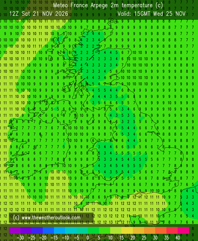
Further north the drop in temperature will be even more extreme, eg around Humberside a drop from 32C max to just 13C 24 hours later! Meanwhile just across the Channel in France Saturday turns up the thermostat well into the 40s.


Yateley, NE Hampshire, 73m asl

"But who wants to be foretold the weather? It is bad enough when it comes, without our having the misery of knowing about it beforehand." — Jerome K. Jerome

Ally Pally Snowman
14 June 2022 17:11:06


ARPEGE goes for 35C on Friday, but only 25-26 on Saturday.

Further north the drop in temperature will be even more extreme, eg around Humberside a drop from 32C max to just 13C 24 hours later! Meanwhile just across the Channel in France Saturday turns up the thermostat well into the 40s.

Originally Posted by: Rob K 

Arpege normally the most accurate I find. So the all time June record is on.


Bishop's Stortford 85m ASL.
Jiries
14 June 2022 17:37:40

Most realistic is temps drop to low 20s not Iceland temps as it never happen before with low 30s to low 10s in high summer and we not in the USA.  if that happen what the hell the deep cold came from.as there no deep cold in the Arctic now.

Polar Low
14 June 2022 18:17:25

Get some foil Jiries  and foil all  windows that will last 3 or 4 days so no need to worry about cool spell, take off about Tuesday when in mid 20c again 👍 


Most realistic is temps drop to low 20s not Iceland temps as it never happen before with low 30s to low 10s in high summer and we not in the USA.  if that happen what the hell the deep cold came from.as there no deep cold in the Arctic now.

Originally Posted by: Jiries 

Ally Pally Snowman
14 June 2022 19:06:37

Interesting ECM 12z a short breakdown soon settles down again and some extreme heat returns at the end.


Bishop's Stortford 85m ASL.
DEW
  • DEW
  • Advanced Member
14 June 2022 19:06:56


Arpege normally the most accurate I find. So the all time June record is on.


Originally Posted by: Ally Pally Snowman 

Target is 35.6C; June 28th 1976 in Southampton.

Ridiculous to think that you could step onto  a ferry in England at 20C and step off into 40C in France! Where are the big thunderstorms?


I can calculate the movements of stars, but not the madness of men - Isaac Newton

Chichester 12m asl

Ally Pally Snowman
14 June 2022 19:21:07


Target is 35.6C; June 28th 1976 in Southampton.

Ridiculous to think that you could step onto  a ferry in England at 20C and step off into 40C in France! Where are the big thunderstorms?

Originally Posted by: DEW 

I was wondering what the exact figure was thanks. Yes some extraordinary temperature gradients on offer this weekend 

ECM Saturday night surely going to go bang 18c difference just a couple hundred miles. 

https://www.wetterzentrale.de/de/topkarten.php?map=20&model=ecm&var=2&run=12&time=105&lid=OP&h=0&mv=0&tr=3#mapref


Bishop's Stortford 85m ASL.
Heavy Weather 2013
14 June 2022 19:29:53


I was wondering what the exact figure was thanks. Yes some extraordinary temperature gradients on offer this weekend 

ECM Saturday night surely going to go bang 18c difference just a couple hundred miles. 

https://www.wetterzentrale.de/de/topkarten.php?map=20&model=ecm&var=2&run=12&time=105&lid=OP&h=0&mv=0&tr=3#mapref


Originally Posted by: Ally Pally Snowman 

So on Twitter are saying it’s how the Iberian low moves up and interacts with the jet. Lots of talk about atmosphere being capped. But potential for some big storms with those gradients surely. 

@Rob. It could be time to dust down ready for heatwatch thread, even though it’s only for June record. 


Mark

Beckton, E London

Less than 500m from the end of London City Airport runway.

bledur
14 June 2022 19:40:53

Latest BeeB saying possibility of quite a lot of rain with a low forming to the south plus the disturbance on the air mass boundary. Interesting few days ahead

White Meadows
14 June 2022 20:27:58
Feels like this hot spell (albeit not arrived yet) came out of nowhere. For a long time it’s been, and forecast to be average/ slightly below av temps by day. Only a few days ago the real heat started quickly showing it’s hand.
Brian Gaze
14 June 2022 20:31:00

Feels like this hot spell (albeit not arrived yet) came out of nowhere. For a long time it’s been, and forecast to be average/ slightly below av temps by day. Only a few days ago the real heat started quickly showing it’s hand.

Originally Posted by: White Meadows 

I flagged it up as a possibility on Tuesday 7th June.


Brian Gaze

Berkhamsted

TWO Buzz - get the latest news and views 

"I'm not socialist, I know that. I don't believe in sharing my money." - Gary Numan

roadrunnerajn
14 June 2022 21:01:58

Latest BeeB saying possibility of quite a lot of rain with a low forming to the south plus the disturbance on the air mass boundary. Interesting few days ahead

Originally Posted by: bledur 

Great… I’m doing a endurance cycle event on Dartmoor this coming Sunday… 


Germoe, part of the breakaway Celtic Republic. 80m asl
TimS
  • TimS
  • Advanced Member
14 June 2022 21:25:46
Closest we’ve been to a heatwave without a dedicated TWO thread appearing.
Brockley, South East London 30m asl
CreweCold
14 June 2022 21:49:22

Closest we’ve been to a heatwave without a dedicated TWO thread appearing.

Originally Posted by: TimS 

That’s probably because it’s looking like the weekend could be remembered more for its rainfall than the 24 hours of heat 🤷🏻‍♂️ It’s fine margins but with such a temperature gradient some places could easily see 2-3 inches if everything aligns correctly. 


Crewe, Cheshire

55 metres above sea level

Taylor1740
14 June 2022 22:58:19
GFS 18z shows a max of 31c on Friday in the SE, followed by 30c on Saturday and then around 10c on Sunday...
NW Leeds - 150m amsl
Ally Pally Snowman
15 June 2022 04:46:01

Arpege has 36c this morning for Friday. 

As for the weekend clear as mud.  GFS, ICON, UKMO all have different solutions. 


Bishop's Stortford 85m ASL.
DEW
  • DEW
  • Advanced Member
15 June 2022 06:32:26

Very briefly (computer power lead damaged so not charging - may be off line while this gets sorted)

WX summary - W Europe somewhat cooler, warmth working back from the SW in week 2

GFS Op - HP most developed on Friday , then shrinks to small ridge from the west while LP develops in Channel; Britain then sandwiched between HP on Atlantic and Lp over Scandinavia (which is cooling Europe), could go either way until new HP over S england Wed 28th.

FAX moves cold front S to Channel and then shows LP over England with frontal activity

GEFS for S peak of heat followed by heavy rain Sat 18th then norml temps and small amounts of rain

ECM tends to keep and then expand that ridge of HP


I can calculate the movements of stars, but not the madness of men - Isaac Newton

Chichester 12m asl

moomin75
15 June 2022 07:22:51
ECM 0Z looks very nice this morning after a brief unsettled spell.
Witney, Oxfordshire

100m ASL

ballamar
15 June 2022 08:02:48
UKV has some heat over the SE retained Sunday - big differences

Remove ads from site