In terms of weather impact and the scale of it, the Great Storm of February 1933 was the greatest weather event of the 1930s that struck the British Isles, it was one of the greatest weather events of the 20th century.
On the 23rd of February 1933, a low pressure developed and pushed north-northeastwards against a block of high pressure to the north of the UK. The weather had been wintry with snowfalls before the storm and with the developing storm engaging the colder air, there were heavy snowfalls and with a tightening pressure gradient, blizzards.
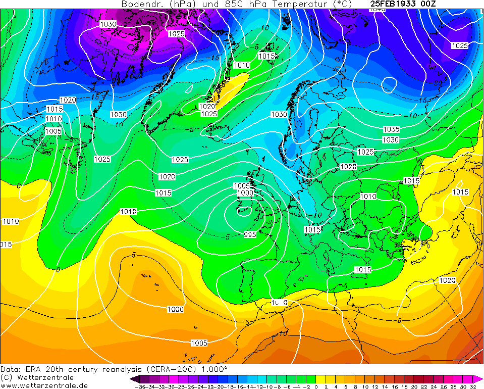
Over the next 2 days, the area of snow and blizzards slowly pushed northwards, allowing a thaw to set in the far south with flooding but further north, the blizzard raged on with depths of level snow of nearly 2ft and huge drifts. Many communities in northern England, the Midlands, Wales and southern Scotland were isolated but conditions over Ireland were truely appalling such that Ireland was virtually cut off from the outside world with all forms of transports and communications, with the exception of radio, crippled.
Milder weather finally pushed northwards by the 27th but then the great thaw set in with flooding and further chaos.
Weather forecast broadcasted by the BBC at 6pm on the 23rd February 1933
"Weather forecast for tonight and tomorrow- A complex low pressure system is developing over the British Isles and the North Sea and the most important centre is moving slowly southward over Ireland and deepening considerably. Snow is expected in many parts of the country and road traffic is likely to be affected in several districts. In Ireland, Wales and southwest England, there will be heavy snowfall inland tonight but there will be sleet or rain near the southwest seaboard. In Scotland and northern england there will be occasional snow especially near the east coast. In southeast England and the Midlands weather will be fine at first with sharp frost and local fog, but there is a considerable likelihood of snow tomorrow.
Outlook for Saturday: Wintry weather continuing, with snow at tmes in many districts."
Some data
A gust of 85mph was recorded at Calshot on the 24th February
Rainfall/melted snow totals from 24th to 26th Feb
Selbourne: 4.74 inches
Petersfield: 4.35 inches
Hoddington: 3.38 inches
28 inches of snow at Harrogate
24 inches on average of snow at Buxton
7 inches of snow at Ross-on-Wye
8 inches of snow at Cranwell
Guardian reports
24th February
Weather report https://i.imgur.com/WY0IlqG.jpg
Snow https://i.imgur.com/EEGkPa4.jpg https://i.imgur.com/w8O4hjz.jpg https://i.imgur.com/TJvPn8K.jpg
25th February
Weather report https://i.imgur.com/cORyNtp.jpg
Blizzard https://i.imgur.com/GrmlLUX.jpg https://i.imgur.com/1p7Tg3Z.jpg
Impact on Manchester https://i.imgur.com/gA2aHN1.jpg https://i.imgur.com/dKC9iXM.jpg
Cheshire https://i.imgur.com/goi52kC.jpg
State of roads https://i.imgur.com/40wLsCj.jpg
https://i.imgur.com/fjhSsMU.jpg
Wales https://i.imgur.com/IxxnidE.jpg
Photos
Kent https://i.imgur.com/W8Z989Q.jpg Manchester https://i.imgur.com/EJDwVhB.jpg
Rail chaos https://i.imgur.com/pryDPVr.jpg
Motoring across fields https://i.imgur.com/f4n1j4i.jpg
26th February
Weather report https://i.imgur.com/4Fu9igP.jpg
Blizzard https://i.imgur.com/q1ai1Zz.jpg https://i.imgur.com/zpn0feK.jpg https://i.imgur.com/LXp1AZQ.jpg https://i.imgur.com/WAK3xM4.jpg
27th February
Weather report https://i.imgur.com/NBNqrat.jpg
Floods https://i.imgur.com/qu9v36G.jpg
Snow https://i.imgur.com/SNTxK64.jpg https://i.imgur.com/nIxHsk7.jpg
State of roads https://i.imgur.com/wlNeEKN.jpg
Photos https://i.imgur.com/caNKZln.jpg https://i.imgur.com/AFQmwAH.jpg
Shipping https://i.imgur.com/oCpXHhM.jpg
28th February
Weather report https://i.imgur.com/QlxZk5G.jpg
Photo https://i.imgur.com/6UXpWnq.jpg
Flood/snow https://i.imgur.com/lKnd26e.jpg https://i.imgur.com/Nft5KYE.jpg https://i.imgur.com/IJ61E8Z.jpg
1st March
Floods https://i.imgur.com/g7NfiKg.jpg
Photo https://i.imgur.com/AOFrJgA.jpg
Train lost for 4 days found https://i.imgur.com/yhTQeEf.jpg
MANCHESTER SUMMER INDEX for 2021: 238 Timelapses, old weather forecasts and natural phenomena videos can be seen on this site
http://www.youtube.com/channel/UCgrSD1BwFz2feWDTydhpEhQ/playlists