The Weather Outlook

Remove ads from site

Gusty
01 February 2021 11:22:19

 A clear shift in the suite, but it would be foolish to make any conclusions on one run. Also the GFSP had if anything gone colder mid term.

My position remains - cross model agreement at 120hrs out is a minimum and we don’t have it yet. 
And wobbles are not a new phenomenon.

Originally Posted by: nsrobins 

We just need to be sure we have a baseline and that we don't eventually receive CMA on the 19th March or something like that ! 


Steve - Folkestone, Kent

Current conditions from my Davis Vantage Vue

https://www.wunderground.com/dashboard/pws/IFOLKE11 

Join Kent Weather on Facebook.

https://www.facebook.com/stevewall69/ 


tallyho_83
01 February 2021 11:29:06

Mean looks good still even Control is much colder so 6z Op is big outlier upto 168h.

Originally Posted by: Ally Pally Snowman 

Wow! The 06z ENS mean has jumped some 3.0c warmer for the 7th February. ENS mean Avg is -5.4c on 7th compared to the -8.3c on the 00z run.

Of course the control and Op are a milder option which may have dragged the mean up but that's quite a swing in the mean isn;t it? It's in less than 7 days time as well.


Home Location - Vixen Tor Close, Okehampton, Devon (221m ASL)

---------------------------------------

Sean Moon

Magical Moon

www.magical-moon.com

Ally Pally Snowman
01 February 2021 11:32:51


It's actually like the 06z run of yesterday and that was out of kilter with the main pack.

Originally Posted by: Shropshire 


Exactly worrying about the GFS 6z is literally pointless.  If the ECM 12 Op and ensembles go mild later then start worrying. 


Bishop's Stortford 85m ASL.
Gusty
01 February 2021 11:32:53

The 6z GEFS for Folkestone continue to trickle. Based off this run there are definitely fewer cold options but the cold cluster still just about holds on as favourite.

https://www.wetterzentrale.de/en/show_diagrams.php?geoid=49909&model=gfs&var=2&run=6&lid=ENS&bw=1

I'm also tracking Aberdeen that I regard as 'safe'. Not too much difference up there for Doc as things stand.

https://www.wetterzentrale.de/en/show_diagrams.php?geoid=51243&model=gfs&var=2&run=6&lid=ENS&bw=1


Steve - Folkestone, Kent

Current conditions from my Davis Vantage Vue

https://www.wunderground.com/dashboard/pws/IFOLKE11 

Join Kent Weather on Facebook.

https://www.facebook.com/stevewall69/ 


fairweather
01 February 2021 11:34:18

Average 850s for the SE on the 0z run for 7th Feb was -8.3C. on the 06z run its -5.4C.

We have also lost the clustering and there is more scatter on the ensembles.

Originally Posted by: Heavy Weather 2013 

That is the biggest concern, rather than the op itself. There is no distinct colder cluster thus increased uncertainty and the snap looks a day shorter. The lowest mean point is now -7C against -8.9C  yesterday. On the other hand it was only -6C a couple of days back and we were talking about a cold spell then!


S.Essex, 42m ASL
Sevendust
01 February 2021 11:34:21

The concern remains the lack of agreement and I am increasingly sure that for my area the chances of a decent snow event are not great, despite the unsettled nature of the models.

I return to the point that the set up could bring a lot of rain to the south with the addition that should we be heading the way of the GFS 6z op it will become stormy.

moomin75
01 February 2021 11:39:28


Exactly worrying about the GFS 6z is literally pointless.  If the ECM 12 Op and ensembles go mild later then start worrying. 


Originally Posted by: Ally Pally Snowman 

I don't think there is any point worrying whatever the outcome. Spring is one month away, what will be will be. One rogue 6z run certainly doesn't worry me, and even if it is yet another new trend, who cares, as long we have our health and can look forward to a better 2021. I am not remotely fussed either way. It would be lovely to get a meaningful cold spell, but if we don't, hey, Spring is around the corner. Reasons to be cheerful. Be nice to each other.


Witney, Oxfordshire

100m ASL

fairweather
01 February 2021 11:40:36


Wow! The 06z ENS mean has jumped some 3.0c warmer for the 7th February. ENS mean Avg is -5.4c on 7th compared to the -8.3c on the 00z run.

Of course the control and Op are a milder option which may have dragged the mean up but that's quite a swing in the mean isn;t it? It's in less than 7 days time as well.

Originally Posted by: tallyho_83 

It's actually -7.0C at its lowest point on 7th/8th on the 06z. -8.9C at lowest point yesterday.


S.Essex, 42m ASL
warrenb
01 February 2021 11:42:05
In situations like this the MEAN is a pointless measurement to be using, as will the mean pressure patterns. To be honest in nearly all situations the mean is pointless. It is the ensemble set that you need to look at.

Example, the 25 runs go for -10, but 5 runs losses the plot and goes for +10, the mean is -6, so almost halving the mean where the vast majority of the runs are -10.

Look at the story in the ensembles.


tallyho_83
01 February 2021 11:45:24


It's actually -7.0C at its lowest point on 7th/8th on the 06z. -8.9C at lowest point yesterday.

Originally Posted by: fairweather 

For London? Yes I saw that - still a big jump though isn't it?

If we were going to get cold and snow with an easterly the 7th/8th was the day to watch..?


Home Location - Vixen Tor Close, Okehampton, Devon (221m ASL)

---------------------------------------

Sean Moon

Magical Moon

www.magical-moon.com

tallyho_83
01 February 2021 11:56:06

Just when the GEM, PARA and Especially the ECM looks like sorting itself out and back on track then the 06z GFS Op and control go off track!!They are milder option and as someone said the Op is the mildest on 6th but the fact they both go mild is a concern - 12z? things will change? ENS members still remain cold but of course with the OP and Control run being milder esp on 6th/7th it really has pulled the mean up. Still not over and done with though. 


Home Location - Vixen Tor Close, Okehampton, Devon (221m ASL)

---------------------------------------

Sean Moon

Magical Moon

www.magical-moon.com

doctormog
01 February 2021 11:58:57

The 6z GEFS for Folkestone continue to trickle. Based off this run there are definitely fewer cold options but the cold cluster still just about holds on as favourite.

https://www.wetterzentrale.de/en/show_diagrams.php?geoid=49909&model=gfs&var=2&run=6&lid=ENS&bw=1

I'm also tracking Aberdeen that I regard as 'safe'. Not too much difference up there for Doc as things stand.

https://www.wetterzentrale.de/en/show_diagrams.php?geoid=51243&model=gfs&var=2&run=6&lid=ENS&bw=1


Originally Posted by: Gusty 

I'm still of the mindset that this (and other 06z op runs) are often not in keeping with much of the daily model output and usually put less faith in them, (unless they are consistent with the rest of the day's output) - which is a bit of a pity as the mean gets as low as -11.1ºC!

I do agree about the uncertainty although don't think the 06z op run is the favoured outcome based on the current consensus. That could change and as ever time will tell.


CField
01 February 2021 12:02:46

This winter continues to throw up fresh new trends despite the lack of snow /frost in the south.

Spring will be very interesting this year,  be good to see a good old fashioned north blast with snow showers even in the south followed by early taste of summer like the ones I remembered when I was a kid. 


Favourite snowstorm

Famous channel low

Dec 31st 1978

Hastings East Sussex

Foot of level snow severe drifting

Next day max temp -4 degrees Celsius

tallyho_83
01 February 2021 12:02:52

06z Operational at it's coldest is -5.4c on 8th/9th February. Surely this is a blip after the coldest of -8.9c in the 00z run?

No description available.


Home Location - Vixen Tor Close, Okehampton, Devon (221m ASL)

---------------------------------------

Sean Moon

Magical Moon

www.magical-moon.com

Hippydave
01 February 2021 12:04:15

A quick flick through the 6z ens from T120 to T270 ish and the Atlantic is very active on most of the members with around 3 groups IMO:-

1) too active for cold to make much progress down the UK, still chilly/cold for Scotland but even here milder incursions.

2) initial cold push succeeds but is pushed away from the south at least shortly after.

3) a small group doesn't ramp things up so much and cold/chilly lasts longer down south. 

Given previous ens sets I'd be suspicious of this one simply because of what has preceded it but will make the 12z run interesting viewing!

The annoying thing I guess is we're not talking about whether the short term shenanigans leads to wet, windy and temps of 12c versus wet, very windy and temps of 8c, we're talking about whether down south (IMBY specifically) at least the evolution leads to cold and snow or milder/mild and wet. I doubt we'd really notice the change in outcome for the former scenario but we're very definitely going to notice it for the latter


Home: Tunbridge Wells

Work: Tonbridge

Saint Snow
01 February 2021 12:04:44

06z Operational at it's coldest is -5.4c on 8th/9th February. Surely this is a blip after the coldest of -8.9c in the 00z run?

No description available.

Originally Posted by: tallyho_83 


Blip.... trend.... flip a coin to decide.


Martin

Home: St Helens (26m asl) Work: Manchester (75m asl)

A TWO addict since 14/12/01

"How can wealth persuade poverty to use its political freedom to keep wealth in power? Here lies the whole art of Conservative politics."

Aneurin Bevan

tallyho_83
01 February 2021 12:11:30


Blip.... trend.... flip a coin to decide.

Originally Posted by: Saint Snow 

Let's hope so saint - The Control run isn't so good either. The 06z OP is a milder option throughout the whole and worse of all the precipitation spikes are back! I just thought if we can't get a decent easterly and or cold weather with proper long lasting cold and snow then let's have it mild and warm - last thing we all want and need is more rain surely.


Home Location - Vixen Tor Close, Okehampton, Devon (221m ASL)

---------------------------------------

Sean Moon

Magical Moon

www.magical-moon.com

SnowyHythe(Kent)
01 February 2021 12:13:30
Anyone else treating the GFSp as the new Op run? Isn’t it due to be replacing the Op this month anyway?

I’m quietly confident of cold reaching our shores this coming weekend. 60/40 in the cold evolution camp at the moment..

Rob K
01 February 2021 12:13:35

I never like to see a cold plunge in the eastern US at this time of year as it usually results in the jet firing up and writing off our winter.

And that is some cold plunge. -20C uppers into Georgia, and -30C as far south as northern Kentucky.


Yateley, NE Hampshire, 73m asl

"But who wants to be foretold the weather? It is bad enough when it comes, without our having the misery of knowing about it beforehand." — Jerome K. Jerome

Gooner
01 February 2021 12:16:34

Anyone else treating the GFSp as the new Op run? Isn’t it due to be replacing the Op this month anyway?

I’m quietly confident of cold reaching our shores this coming weekend. 60/40 in the cold evolution camp at the moment..

Originally Posted by: SnowyHythe(Kent) 

the next GFS (v16) upgrade, which will include doubled vertical resolution (64 to 127 layers), more advanced physics, data assimilation system upgrades, and coupling to a NCEP's Global Wave Model using the Unified Forecast System (UFS) community model. Implementation of GFSv16 is targeted for the early winter of 2021.

https://vlab.ncep.noaa.gov/web/environmental-modeling-center/unified-forecast-system


Remember anything after T120 is really Just For Fun


Marcus

Banbury

North Oxfordshire

378 feet A S L


hobensotwo
01 February 2021 12:17:34


Blip.... trend.... flip a coin to decide.

Originally Posted by: Saint Snow 

It's worrying that it has support.

Maybe as its the OP it's sampling different scenarios, before committing to it's final solution. Not sure if it works like that.

I will tell myself anything to keep the faith going.😊

What I will say is that if the main cluster was mild and the op through out a cold one I would take note.

tallyho_83
01 February 2021 12:21:50

I never like to see a cold plunge in the eastern US at this time of year as it usually results in the jet firing up and writing off our winter.

And that is some cold plunge. -20C uppers into Georgia, and -30C as far south as northern Kentucky.

Originally Posted by: Rob K 

I saw this happening as forecast by models a week ago - when I saw this I did question myself that this pattern in NE America and Canada usually blasts up the jet with low pressure system,s coming off Atlantic flattening any ridge to give us cyclogenisis and just spells of wind and rain and zonal dross.

https://www.bbc.co.uk/weather/5128581

I think this could be a factor as to why the models have struggled and why we can't get the cold really.

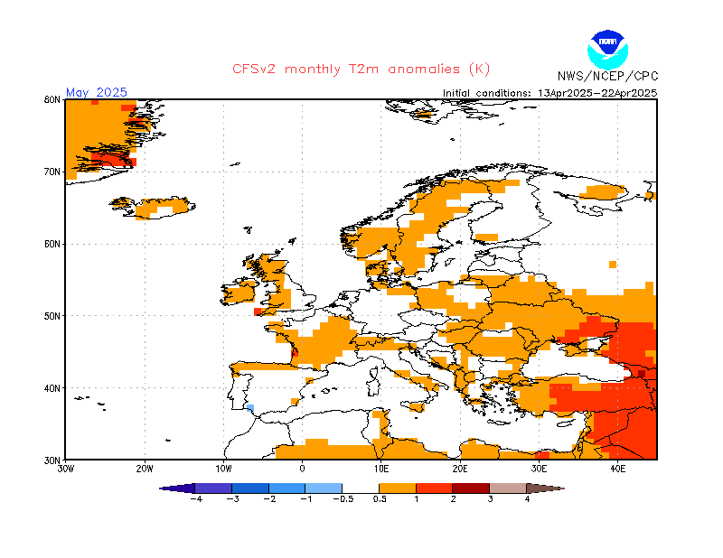
Just a reminder:

Feb temp forecast from CFSv2 which shows below average temperatures for the month of Feb. Any easterly would be welcome with all that cold air over Scandinavia. 

Home Location - Vixen Tor Close, Okehampton, Devon (221m ASL)

---------------------------------------

Sean Moon

Magical Moon

www.magical-moon.com

hobensotwo
01 February 2021 12:47:07


I saw this happening as forecast by models a week ago - when I saw this I did question myself that this pattern in NE America and Canada usually blasts up the jet with low pressure system,s coming off Atlantic flattening any ridge to give us cyclogenisis and just spells of wind and rain and zonal dross.

https://www.bbc.co.uk/weather/5128581

I think this could be a factor as to why the models have struggled and why we can't get the cold really.

Just a reminder:

Feb temp forecast from CFSv2 which shows below average temperatures for the month of Feb. Any easterly would be welcome with all that cold air over Scandinavia. 

Originally Posted by: tallyho_83 

To be fair that anomaly chart shows below average temps for most of the UK, but note parts of the South East & extreme South are just average. Also note the Mild anomalies to the South, Mid France, Spain, North Africa etc.

Is that not what the 6z op is showing, warm plumes wrapped around the Eastern side core of the low, bringing average temps to the South, cold temps further North, as air is coming in from Scandi.

If you take a snapshot of the 850s chart from the 6z op for next weekend it fits quite well.

Southerly tracking lows are just going to spin up that warmer air into the South. We're gonna need a push from the North East, to help us snow starved Southerners.

Brian Gaze
01 February 2021 12:51:18

Big shift on the 6z update. That has put the cat among the pigeons. I'll post the data table comparison shortly.


Brian Gaze

Berkhamsted

TWO Buzz - get the latest news and views 

"I'm not socialist, I know that. I don't believe in sharing my money." - Gary Numan

Gandalf The White
01 February 2021 12:57:14

The ECM 00z clusters for T+120 to T+168 (this weekend)  show a basic theme of easterlies but with variations on wind direction and proximity of low pressure.

https://apps.ecmwf.int/webapps/opencharts/products/cluster_plot_legA?base_time=202102010000&cluster=120_168&parameter=1000


Location: South Cambridgeshire

130 metres ASL

52.0N 0.1E


Remove ads from site