The Weather Outlook

Remove ads from site

doctormog
07 December 2019 18:39:22

ECM 144 in isolation looks like the Arctic could influence - if I am allowed to search for cold in the charts!!

Originally Posted by: ballamar 

If you look at the NH view at that time point and also on the UKMO you can see the higher pressure over the high Arctic at that time. What if any impact it will have remains to be seen.

As GTW says it is an unsettled outlook with alternating period of colder and milder periods in the coming week to ten days. Beyond that e GFS FI has basically offered a variety of options on its last three runs.


ballamar
07 December 2019 18:43:57


If you look at the NH view at that time point and also on the UKMO you can see the higher pressure over the high Arctic at that time. What if any impact it will have remains to be seen.

As GTW says it is an unsettled outlook with alternating period of colder and milder periods in the coming week to ten days. Beyond that e GFS FI has basically offered a variety of options on its last three runs.

Originally Posted by: doctormog 

The signs in models can start before we have 80% of ENS below -10! Will keep an eye on the Arctic for any inflation which could cause a cold outbreak. Would be interesting even if only for northern areas

Arcus
07 December 2019 20:32:35
As I mentioned the other day, the PV attack is looking like a purely displacement exercise with a NW Eurasion relocation. The effect for us in the UK is going to be at best cool/cold zonality as the entrenchment of LP in NW Europe spawns Lows in the N. Atlantic and we get some nasty detritus (i.e. storms) in the wash from the NW. So not classic zonality, but not great signs of blocking in our neighbourhood. Wave 2 may push things, but it looks like the PV is being battered and wandering, but standing firm.
Ben,

Nr. Easingwold, North Yorkshire

30m asl

idj20
07 December 2019 21:21:20

I guess the only crumbs of comfort I could derive out of this coming week's active Atlantic-driven pattern is the wind being mostly of a westerly component so at least I'd be largely sheltered by the built up hilly bit (only late Tuesday has more of a southerly feature) and the rain bands themselves are likely to be moving swiftly through the UK rather than stalling so the rainfall total for December may end up being lower than the 223 mm I've had for November.

But other than that . . . roll on Spring. 


Home location: Folkestone Harbour.
nsrobins
07 December 2019 22:52:07
This might sound a tad left field, but I’m getting rumblings of a significant deceleration in the mobility after 12 days. The last few GFS op runs have hinted at higher latitude blocking - the sort that can deliver at short notice.

There - that’s my optimistic head fuelled by a few decent pints of Bowman’s Swift One.

Now on to this evenings offerings:


Neil

Fareham, Hampshire 28m ASL (near estuary)

Stormchaser, Member TORRO

Arbroath 1320
08 December 2019 00:02:43

This might sound a tad left field, but I’m getting rumblings of a significant deceleration in the mobility after 12 days. The last few GFS op runs have hinted at higher latitude blocking - the sort that can deliver at short notice.
There - that’s my optimistic head fuelled by a few decent pints of Bowman’s Swift One.
Now on to this evenings offerings:

Originally Posted by: nsrobins 

I think you're spot on. I've only been checking the charts every few days over the last week, so have not noticed the detail run to run. What is clear though is that the models have backed away from a prolonged height rise over mainland Europe in FI. The Atlantic train seems to lose energy in the run up to Christmas. Will be interesting to see over the next few days if the models are picking up on a pattern change, or whether it is just the usual erratic FI flip flopping.


Kenmore, Highland Perthshire, GGTTH
DEW
  • DEW
  • Advanced Member
08 December 2019 07:10:55

Forecasts for this coming week stable i.e. the same as yesterday, zonal with depressions embedded in the flow - Monday's is labelled storm Atiyah (BBC has centre near Hebrides, GFS & ECM near Norway), GFS & ECM now agree on Wed (945 mb off Iceland) and Fri (GFS 945 mb off Orkney, ECM less deep but both bring cold air south)

GFS then slackens off, less deep LP though watch for something cold and wet around Wed 18th after which in complete contrast to yesterday we have LP sliding past Cornwall and anchoring itself near Corsica Sat/Sun 21st/22nd. Finally strong rise of pressure over Ireland on 24th. That looks much more like the day before yesterday's forecast, almost as if GFS is just trying things out to get audience reaction. 

Jetstream, too, has drawn back from an extreme southerly track at the end of the forecast period and after running strongly across the UK this week starts developing loops but these are mostly to the E of UK guiding colder weather S over Europe.

GEFS ens temps up and down to 12th, then most runs close to seasonal average, pptn quite general, heavier in the far N at first and then in the S later.

Week1 looks fixed but week 2 remains JFF


I can calculate the movements of stars, but not the madness of men - Isaac Newton

Chichester 12m asl

Brian Gaze
08 December 2019 08:31:03

The most notable thing from the cold angle is the lack of ensemble runs bringing in -10C 850hPa. In northern locations a few runs are getting closer but even they look like transient dips from the north. 


Brian Gaze

Berkhamsted

TWO Buzz - get the latest news and views 

"I'm not socialist, I know that. I don't believe in sharing my money." - Gary Numan

marting
08 December 2019 08:31:11

The charts have changed quite a lot in the last 24 hours with some heights appearing in almost the right places for cold. Hopefully this will continue to evolve 👍


Martin

Greasby, Wirral.

Shropshire
08 December 2019 08:49:48

The charts have changed quite a lot in the last 24 hours with some heights appearing in almost the right places for cold. Hopefully this will continue to evolve 👍

Originally Posted by: marting 

Christ, if you can take something positive out of this mornings output fair play to you. It's dreadful for coldies IMO.


From December 27th 2020, zonality will be banned from mixing with the UK. We appreciate that this may come as a shock to younger people and old Uncle Barty. This ban will last for a minimum of ten days.
doctormog
08 December 2019 08:56:12


Christ, if you can take something positive out of this mornings output fair play to you. It's dreadful for coldies IMO.


Originally Posted by: Shropshire 

It’s dreadful for mildies.and settledies too. 

If you like blustery showers, mild Tuesdays and westerly gales then it is a good outlook. Overall not much change as DEW says in the coming week and chilly at times in northern parts, albeit nothing notable. 

No prolonged wintriness or settled conditions sum things up I’m afraid. We seem to have everything but the kitchen sink in the forecast up here (from wintriness to thunder and severe gales).


Gusty
08 December 2019 09:15:03

Aside from the cool / mild debate this week is looking potentially very stormy at times. Attention should be drawn to this as the situation developing is very volatile.

The GFS 0z delivers another 40mm to my location in the week ahead...a number mirrored for many.

Orographic influences from the periodic milder sectors delivering copious amounts to higher ground in the north and west.

Modele GFS - Carte prévisions

Notably windy events too.

From a SE England perspectie there are a few periods to keep an eye on.

Tonight 00 - 03.00 hrs

Tuesday evening

Thursday afternoon

Saturday evening

Lots to keep an eye on. 


Steve - Folkestone, Kent

Current conditions from my Davis Vantage Vue

https://www.wunderground.com/dashboard/pws/IFOLKE11 

Join Kent Weather on Facebook.

https://www.facebook.com/stevewall69/ 


doctormog
08 December 2019 09:21:39

Aside from the cool / mild debate this week is looking potentially very stormy at times. Attention should be drawn to this as the situation developing is very volatile.

The GFS 0z delivers another 40mm to my location in the week ahead...a number mirrored for many.

Orographic influences from the milder sectors delivering copious amounts to higher ground in the north and west.
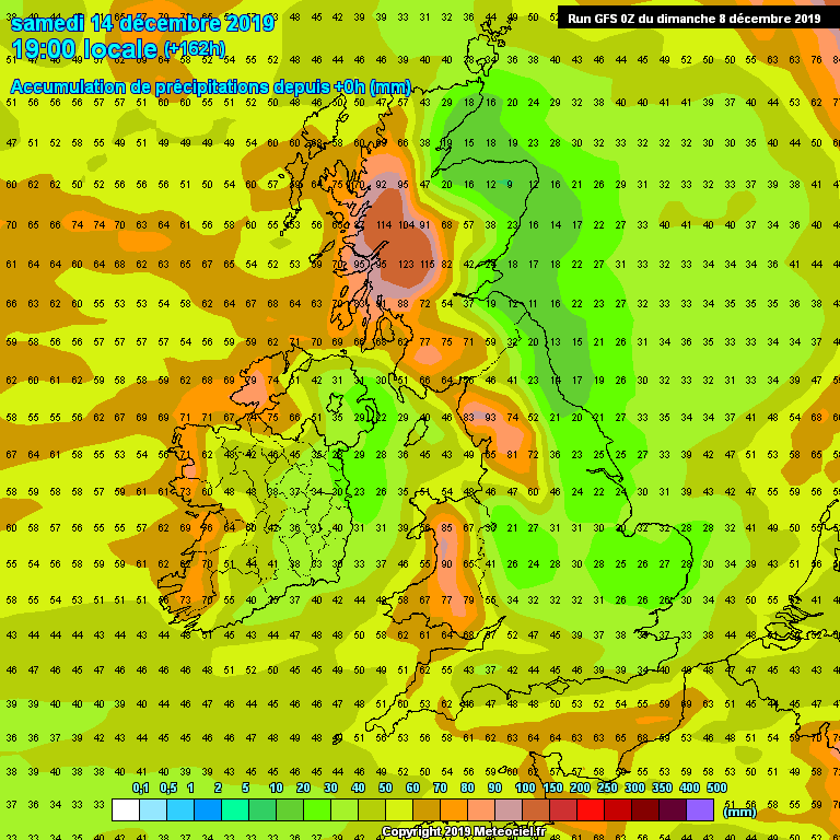
Modele GFS - Carte prévisions

Notably windy events too.

From a SE England there are a few periods to keep an eye on.

Tonight 00 - 03.00 hrs

Tuesday evening

Thursday afternoon

Saturday evening

Lots to keep an eye on. 

Originally Posted by: Gusty 

Yes you are absolutely right Steve and what you highlight are the key issues of this week, all as ever subject to small changed in timing and specifics). 

A bonus from a winter sports point if view is that there might be a notable base established at the W Scotland ski centres (as long as there is no blast from the SW afterwards!)


JACKO4EVER
08 December 2019 09:34:52


It’s dreadful for mildies.and settledies too. 

If you like blustery showers, mild Tuesdays and westerly gales then it is a good outlook. Overall not much change as DEW says in the coming week and chilly at times in northern parts, albeit nothing notable. 

No prolonged wintriness or settled conditions sum things up I’m afraid. We seem to have everything but the kitchen sink in the forecast up here (from wintriness to thunder and severe gales).

Originally Posted by: doctormog 

exactly, bog standard UK winter fayre so early in the season. However it’s the aspects of flooding that may well be rearing it’s head in the news if the pattern persists. 

Brian Gaze
08 December 2019 10:42:27
Agree wrt flooding and strong winds being the main issues. That has been blatantly obvious for days.
Brian Gaze

Berkhamsted

TWO Buzz - get the latest news and views 

"I'm not socialist, I know that. I don't believe in sharing my money." - Gary Numan

Rob K
08 December 2019 11:14:21
Several of my fence posts need replacing and I haven’t had a chance to do it yet. Hoping the whole lot doesn’t come down this week 😞
Yateley, NE Hampshire, 73m asl

"But who wants to be foretold the weather? It is bad enough when it comes, without our having the misery of knowing about it beforehand." — Jerome K. Jerome

marting
08 December 2019 16:32:58

UKMO looks a fairly cool and wet and consistent with their forecast now keeping us cool until 22nd Dec. The arctic high showing signs of developing some interest post 144 in FI. 
martin


Martin

Greasby, Wirral.

Gandalf The White
08 December 2019 16:47:51

UKMO looks a fairly cool and wet and consistent with their forecast now keeping us cool until 22nd Dec. The arctic high showing signs of developing some interest post 144 in FI. 
martin

Originally Posted by: marting 

Indeed it does.

What happened to the unending increasingly mild zonality that a few posters were touting so confidently in recent days?  

To me it's looked like rather cool to rather cold zonality has been on offer in the output for over a week now.  No sign of a predominately mild south-westerly flow; little evidence of a Bartlett; no evidence of a sustained Euro high.

Of course it could all change but so far there's just been a gradual switch to something closer to normal zonality, with occasional milder interludes in between rather longer cooler ones.  The normal daytime maxima for the south in mid-December are around 9c.


Location: South Cambridgeshire

130 metres ASL

52.0N 0.1E


Gusty
08 December 2019 17:31:00

There has been a shift towards colder zonality in the north over the last 36 hours. Indeed, northern England northwards is looking quite wintry at times, especially over the higher ground in post cold front instability from showers piling in off the north Atlantic.

Further south milder air is far more prevalent throughout. Maxes on most afternoons this week in the range 8-11c, whereas parts of central parts of Scotland are looking at maxes of 2- 5c most afternoons.

The usual warming trend north to south will be more marked than usual this week.

Scotland and the north - Colder than average

Midlands southwards - Average to mild.


Steve - Folkestone, Kent

Current conditions from my Davis Vantage Vue

https://www.wunderground.com/dashboard/pws/IFOLKE11 

Join Kent Weather on Facebook.

https://www.facebook.com/stevewall69/ 


dagspot
08 December 2019 17:59:41
... which was what was being suggested a week or so ago, then dismissed...
Neilston 600ft ASL
Brian Gaze
08 December 2019 18:01:30

A marked warming trend is appearing.


Brian Gaze

Berkhamsted

TWO Buzz - get the latest news and views 

"I'm not socialist, I know that. I don't believe in sharing my money." - Gary Numan

marting
08 December 2019 18:20:11

Is it a trend or a 6 hourly change from GFS? Certainly, different from earlier today. Let’s see if it becomes a trend over the next day or so.

At least we can try and follow trends to see how they evolve- they have been all other the place recently 😀 

martin


Martin

Greasby, Wirral.

Brian Gaze
08 December 2019 18:20:59


Brian Gaze

Berkhamsted

TWO Buzz - get the latest news and views 

"I'm not socialist, I know that. I don't believe in sharing my money." - Gary Numan

doctormog
08 December 2019 18:29:45

To be honest I am still more interested in what will happen in the next week to worry about what the next 60 or so GFS runs may show for Christmas Eve. I will give that more attention in a week or ten days.

The ECM 12z run maintains the low pressure dominated outlook to day 6 https://www.wetterzentrale.de/maps/ECMOPEU12_144_1.png 


Shropshire
08 December 2019 18:29:58

Yes, Xmas looming into view on the GFS and it's looking very 1988, or even warmer 


From December 27th 2020, zonality will be banned from mixing with the UK. We appreciate that this may come as a shock to younger people and old Uncle Barty. This ban will last for a minimum of ten days.

Remove ads from site