Evening
Based on the pretty successful thread around the current seasons NH patterns I thought I would lay out the thoughts for Winter 2018.
Headlines
- Following on from Autumn > Winter 18 Globally is set to smash records- From record warmth to record cold, record rainfall & record drought... This will be driven by weak westerlies & a possible SSW in mid December-
Teleconnection notables **could** be
* Lowest negative AO on record ( or at least a challenger )
* Lowest & or most positive POL on record ( this metric can be good for us in either positive or negative mode, however its the extremes of pressure that support the -AO )
* Most negative 100 or 10HPA zonal wind on record in Merra2 data at any point during the Winter ( most likely earlier rather than late )
UK wise - The overall theme is a very high probability of a below average winter with the sub 3c breeched twice - ( maybe 3 times )
Winter NH patterns
For a winter forecast this last 10 or so years a traditional method by most has been adopted - taking the state of the Teleconnective background signals & matching them to analogue years in the 1900s - & I still believe there is some merit in this especially when we are in very high NINO index years as this can be the overuling global driver over & above any favourable ones -
The last 5 years or so have seen attempts to create a winter forecast by morphing analogue years for the stratosphere - again with some limited success-
However there is one fundemental issue with using these analogues which is the assumption that should the same metrics repeat themselves then the tropospheric responses would all align & the H500 height anomalies would be at least very similar across the NH.
Well now, as we get better understanding of how climate change is impacting the weather (most notably the ice & arctic heat ) then all these analogues potentially become redundant due to the troposphere becoming more & more independent in relation to not allowing the stratosphere to downwell - ( otherwise known as being 'decoupled' )
The main driver of this is the surplus warmth left over in the arctic at the end of the summer & Autumn as well as the record breaking ice loss along the peripheral ice edges -
Not only this, as the mid lattitudes heat up we have grown larger more 'intense' areas of high pressure transporting yet more heat upwards into the pole- ( NB even now this week in November we see record High pressure developing towards Scandi pumping more warmth upwards )
The feedback then becomes self perpetuating-
I would also like to add to this the 2018 'spin' that not only does this year have a massive heat anomaly,but perhaps ( IMHO ) a dipole of heat / cold across the areas with early ice build up V no early ice
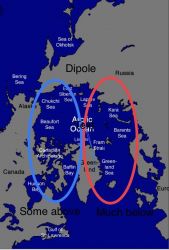
What you then allow is even more inconsistency with heat creating vast gradients across the pole allowing for yet more blocking - & because of the dipole the balance of heat then allows potential displacement of the tropospheric vortex -
Its no wonder then that we see the amount of wave 1 & wave 2 blocking attacking the early vortex & the inability of the stratosphere to couple downwards as the resistence upwards is balancing it out -
What you get as a net of all this is no tropospheric analogues because there isnt a teleconnection that quantifies Arctic Amplification ( AA ) & there are no stratospheric analogues because if the strat cant downwell then its overall strength is much less impactful on the troposphere -
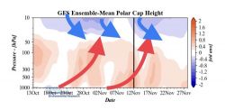
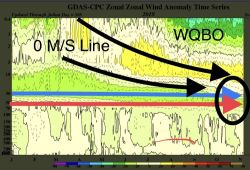
- So as mentioned then- Autumn has been one of blocking highs - even when the stratospheric jet has increased along its seasonal pathway the troposphere has refused to couple with it- ive highlighted this is due to the anomalous vertical heat flux & perpetual bombardment of upward waves thats served to offset the downward propergation of the strat leaving the polar cap sitting in equilibrium
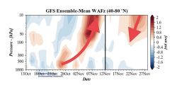
Seen here ( Source AER )
Also shown is the continual warmth in waves pushing upwards from the troposphere - & now potentially down from the strat-
Remember the upper vortex is *Stronger* than average this year so while its vulnerable to attack - early displacement to russia * Isnt * the same as a SSW split - for this we need to see a reversal of the zonal wind @60N/10HPA
* Classic winters like 1962 had early warming over the canadian side which took the vortex out for the entire winter then went on to allow for blocking to remain in situ for long periods of time-
I believe this winters signal of a tropospheric decoupling could allow for a similar scenario especially if the SSW underpins it -
QBO support -
The initial concern is that a downwelling WQBO would omit us from the chances of a SSW however we are still in the transition phase where 30MB moves to positive but the 50MB lower down holds negative- The impacts of this are that the QBO will not act as a blocker early on the potential SSW this winter -
Ive uploaded the image & I should have shortened the timeline but hey ho! h
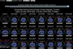
Possible Strat warming ~ Mid December...
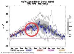
The strat as we know has been under attack this winter & the lower vortex especially has recently born the brunt of any deceleration - dropping to around 5M/S where as higher up the 10HPA wind has remained less impacted
The day 16 disks which when the next wave of vertical flux peak starts to show a canadian warming & relocation of the vortex
 -
-
So worst case scenario a dipsplaced vortex towards Russia, best case is a split & even less eastward zonal wind speed !!
** Key date proposed for major displacement / poss warming Dec 15th but remember because of the decoupling this may only serve to reinforce the blocking thats already there - **
DJF UK CET - Viewpoint & Anomaly plot
The seasonal winter CET stands from Hadley @ 4.13C broken down into
D 4.7 J 3.9 F 3.8
Statistically across the last 100 years
sub 0c months are - 8/300 which is about 1 every 40 years ~ 2.5% chance.
sub 1c months are 17/300 which is about 1 in every 18 years ~ 6% chance
sub 2c months are 29/300 which is about 1 in every 10 years ~ 10% chance.
So we can see the numbers are low- in terms of our chances I try to quantify this winters numbers by saying that a sub 2c is as high as 50/50at this stage ! & sub 1c maybe 25% - Sub 0c maybe 10%...
Overall projected winter CET SUB 3c ~ 2-2.5c
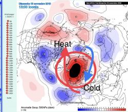
Overall pressure anomaly locations for Winter 18-
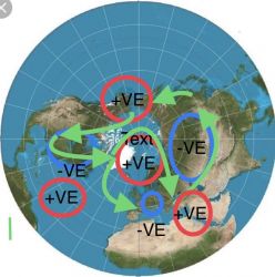
These may wax & wain however general locations feel about right- Storm track is in green - Cold winter for central states as well as possibly the east depending on whether the blocking is more East based towards a +PNA or more west based -EPO ( the further west you get the -EPO you do encourage a ridge on the SE coast )
UK sits on the NW side of the low anomaly in Europe - so in that respect continental air is sent west in our direction- which will drive snow events-
Europe as a whole cold & below ave - especially central & Western, however places like Greece / Turkey could benefit from warmth up from the south -
It is my belief that confidence in the projected patterns for this winter are about as high as they can be in terms of potential blocking- especially in the locations we need it - what you will see from the models is perpetual ridging to the pole from every angle across the globe ( -EPO / -NAO / -POL )
If the vortex remains uncoupled then the speed of the 100HPA vortex is more crucial than the 10HPA one higher up- This will continue into December where the idea of a 'front loaded but possibly fully loaded winter comes from'
- The nature of reduced westeries also impacts the UK around rainfall-
Mean averages especially for the NW will be lower however what you lose over a month in terms of loss of westerly driven wind & rain events may well be offset by slow moving PPN events ( The same as Autumn )
So there you have it - 2018/19 Global extremes of weather & for the UK higher probabilities of exceptional weather which for once is more in favour of exceptional cold instead of warmth..
S