The Weather Outlook

Remove ads from site

Karl Guille
26 December 2016 23:33:00
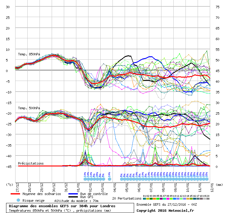
Short GEFS 18z ensembles mean dips below -5 850hPA IMBY which is a degree or so lower than the 12z set!

http://modeles7.meteociel.fr/modeles/gens/graphe_ens3.php?x=225&ext=1&y=245&run=18&runpara=0 


St. Sampson

Guernsey

Zubzero
Gooner
26 December 2016 23:47:40

Number 7 for me please 

http://modeles7.meteociel.fr/modeles/gens/runs/2016122618/gens-7-1-192.png 

Originally Posted by: Zubzero 

This is also a beauty


Remember anything after T120 is really Just For Fun


Marcus

Banbury

North Oxfordshire

378 feet A S L


Rob K
27 December 2016 00:01:07
Ensemble still looks ok but the op is not without support.

http://old.wetterzentrale.de/pics/MT8_London_ens.png 


Yateley, NE Hampshire, 73m asl

"But who wants to be foretold the weather? It is bad enough when it comes, without our having the misery of knowing about it beforehand." — Jerome K. Jerome

The Beast from the East
27 December 2016 00:26:01

a lot more uncertainty regarding the cold spell. May not even happen at all. This could well do down as yet another defeat snatched from the jaws of victory. A common theme in the modern era. The northern jet is simply too strong to enable blocking where we need it

I fear for what the morning will herald for cold weather fans


Purley, Surrey, 70m ASL

"We have some alternative facts for you"

Kelly-Ann Conway - former special adviser to the President

Gooner
27 December 2016 00:32:34

a lot more uncertainty regarding the cold spell. May not even happen at all. This could well do down as yet another defeat snatched from the jaws of victory. A common theme in the modern era. The northern jet is simply too strong to enable blocking where we need it

I fear for what the morning will herald for cold weather fans


Originally Posted by: The Beast from the East 

You are so funny


Comedy gold


Remember anything after T120 is really Just For Fun


Marcus

Banbury

North Oxfordshire

378 feet A S L


David M Porter
27 December 2016 00:53:50

a lot more uncertainty regarding the cold spell. May not even happen at all. This could well do down as yet another defeat snatched from the jaws of victory. A common theme in the modern era. The northern jet is simply too strong to enable blocking where we need it

I fear for what the morning will herald for cold weather fans


Originally Posted by: The Beast from the East 

For gawd's sake, don't you start with this modern era nonsense, Beast!


Lenzie, Glasgow

"A body of men holding themselves accountable to nobody ought not to be trusted by anybody." – Thomas Paine

Phil G
27 December 2016 01:07:48
Don't fear Beast, we can take it!

Don't be such a melt, like a snowman.

There are more important things.

Whether Idle
27 December 2016 06:13:12


I said this time yesterday there was a signature for 2 topplers in the GEFS.  Today there is a firm signature for one toppler (the first).

The Meto has backed off it's stellar charts.

The search for prolonged and deep cold continues! (will the ECM throw a curve ball... though?)

2 Things -

  1. Always remember Murphy's Law
  2. When there is a chance of cold it is foolhardy to look beyond 144 hours.   Anyhow, here are the GEFS and the Met O 144:


STOP PRESS - BUT, as hinted at in my intro, the ECM does throw this into the mix at 144:by far the best for cold as we head into FI, which is clearly at round 120, so anything beyond is JFF as someone once said.


Dover, 5m asl. Half a mile from the south coast.
JACKO4EVER
27 December 2016 06:32:08
Good morning, not the best of news if it's an extended cold snowy spell your after. Looks like a toppler to me with the jet flattening any northwards extending HP fairly easily. Thereafter quite possibly remaining cool though further runs needed.
moomin75
27 December 2016 06:33:02

Well, after the 12zs I think the writing was on the wall for an extended cold spell, and there is, as you may have been expecting, not the best news in that respect this morning.

I said this time yesterday there was a signature for 2 topplers in the GEFS.  Today there is a firm signature for one toppler (the first).

The Meto has backed off it's stellar charts, and is much more ECM-esque up to 144.

The search for cold continues! (will the ECM throw a curve ball... though?)

2 Things -

  1. Always remember Murphy's Law
  2. When there is a chance of cold it is a crying game to look beyond 144 hours.   Anyhow, here are the GEFS and the Met O 144:


Originally Posted by: Whether Idle 

To be honest. Anyone led up the garden path by Christmas charts showing intense blocking are naive. The more experienced among us know only too well to disregard whatever is being shown from 24th to 26th December. It happens EVERY year. I don't care what the doubters say. On this one I am with Retron. It is very abundantly clear that runs over Christmas are not to be relied on. 


Witney, Oxfordshire

100m ASL

Whether Idle
27 December 2016 06:40:52

The ECM sends the cold shot to Germany and the eastern Alps.  More runs needed.


Dover, 5m asl. Half a mile from the south coast.
Tim A
27 December 2016 06:43:32

Rather the missing data the main issue IMO is that posters looking for an extended cold spells are looking well out into FI so outlook is bound to change from run to run. Happens all the time regardless of whether Xmas. Only the initial incursion is anywhere near the reliable timeframe .

Also look at the Met office 6 to 15 day forecast . It is broadly in line with the models and was written yesterday and seems a good reflection of cirrent thinking.  Northerly incursion. High pressure. Possibility of further incursion. We should be looking for the 2nd incursion now but this time period is well out in FI.


Tim

NW Leeds

187m asl

 My PWS 

KevBrads1
27 December 2016 06:45:30

Ian Ferguson on "missing" Christmas data

Meteorological trade runs 24-7 even over Christmas(!); the satellite data keeps churning; many aircraft providing data... etc. I've never heard such a 'theory' espoused anywhere before.

Ian Ferguson on UKMO 144hrs

Incidentally, someone posted along lines of UKMO-GM being of no credence at T+144, but I've never seen evidence for that published or cited elsewhere.


MANCHESTER SUMMER INDEX for 2021: 238

Timelapses, old weather forecasts and natural phenomena videos can be seen on this site

http://www.youtube.com/channel/UCgrSD1BwFz2feWDTydhpEhQ/playlists

backtobasics
27 December 2016 07:14:38


I said this time yesterday there was a signature for 2 topplers in the GEFS.  Today there is a firm signature for one toppler (the first).

The Meto has backed off it's stellar charts.

The search for prolonged and deep cold continues! (will the ECM throw a curve ball... though?)

2 Things -

  1. Always remember Murphy's Law
  2. When there is a chance of cold it is foolhardy to look beyond 144 hours.   Anyhow, here are the GEFS and the Met O 144:


STOP PRESS - BUT, as hinted at in my intro, the ECM does throw this into the mix at 144:by far the best for cold as we head into FI, which is clearly at round 120, so anything beyond is JFF as someone once said.


Originally Posted by: Whether Idle 

An extended cold spell was never modelled, there was no garden path, just hints at a cool down.  the 'suggestion' as far as I can see is two shots of cold 5 or so days apart the first one now looking likely but severity very much open for debate.

I really don't get the comments in here this morning, we're just seeing variations on a theme. 

doctormog
27 December 2016 07:19:26

I'm guessing it's just me that sees the repeated N Atlantic - Greenland ridging as a rather good thing. There are some wind up merchants here which gives a totally warped view to the casual reader.

Perhaps some would also do well to heed IF's points. The prospects of cold and snowy conditions continue to be higher in the current outlook that at any other stage of the winter so far. If you're looking for Jan 1963 or Dec 2010 however, I would urge a little caution!

Edit: Basically what the post above mine says   (Thanks b2b).


Brian Gaze
27 December 2016 07:54:51

I'm guessing it's just me that sees the repeated N Atlantic - Greenland ridging as a rather good thing. There are some wind up merchants here which gives a totally warped view to the casual reader.

Perhaps some would also do well to heed IF's points. The prospects of cold and snowy conditions continue to be higher in the current outlook that at any other stage of the winter so far. If you're looking for Jan 1963 or Dec 2010 however, I would urge a little caution!

Edit: Basically what the post above mine says   (Thanks b2b).

Originally Posted by: doctormog 

I'm not sure whether most of them are wind up merchants or just don't understand basic probability. I hope it's the former because if not it suggests that schooling in the UK is dire! I also notice the comments about the UM 144 are back in circulation but give it a short time and these will be juxtaposed with equally daft suggestions that the Met Office have secret model data which blows away the "free" stuff we view and analyse.  The big picture hasn't changed significantly this morning with a cold snap this weekend looking the form horse and a more varied and at times colder pattern likely to continue as we head into January.


Brian Gaze

Berkhamsted

TWO Buzz - get the latest news and views 

"I'm not socialist, I know that. I don't believe in sharing my money." - Gary Numan

Joe Bloggs
27 December 2016 07:55:48

The charts look great to me this morning!

Maybe I'm missing something.

The ECM in particular is stunning. 

nsrobins
27 December 2016 08:00:48
You're not missing anything Joe. It's business as usual on TWO where we shouldn't let a strong cold front with snow showers following and hard frosts get in the way of the facts 😉

The general theme really remains unaltered and one shouldn't let individual OP runs distract from the mean trend.


Neil

Fareham, Hampshire 28m ASL (near estuary)

Stormchaser, Member TORRO

Gusty
27 December 2016 08:03:33

Ignoring the 'questionable' charts of the 25-26th December we are pretty much where we were on Christmas Eve.

A cold front sweeps south on News Years Day bringing the risk of snow showers to exposed coasts in the north. Given a NE'ly feed on the 2nd we are looking at a wintry shower risk extending to eastern Britain, even the SE could see some wintry showers over the higher ground for a time before the High Pressure topples on the 3rd/4th.

A spell of cold and frosty weather is then likely for a time whilst the high pressure makes up its mind where it goes next. There has been enough evidence to suggest it may retrogress for a second bite but confidence is low again as the jam tomorrow scenarios are once again in FI.


Steve - Folkestone, Kent

Current conditions from my Davis Vantage Vue

https://www.wunderground.com/dashboard/pws/IFOLKE11 

Join Kent Weather on Facebook.

https://www.facebook.com/stevewall69/ 


Joe Bloggs
27 December 2016 08:05:00

You're not missing anything Joe. It's business as usual on TWO where we shouldn't let a strong cold front with snow showers following and hard frosts get in the way of the facts 😉

The general theme really remains unaltered and one shouldn't let individual OP runs distract from the mean trend.

Originally Posted by: nsrobins 

lol.

I think people are feeling disheartened because (on GFS) , we are seeing repeated Atlantic ridging/amplification rather than sustained Greenland High. Both options are plausible at this time, and both options have snow opportunities associated with them, albeit one more than the other. More runs needed on that front. GEFS show the uncertainty - quite a significant spread. http://old.wetterzentrale.de/pics/MT2_Manchester_ens.png

http://old.wetterzentrale.de/pics/MT8_Manchester_ens.png - some very cold runs in there, but quite a significant split between very cold and much milder. The op one of the milder options. 

Meanwhile, IF has had quite the ramp on the other side! 

Rob K
27 December 2016 08:20:35

Anyone who claims they can predict what the weather will be doing in 10 days from this needs to fill in my lottery slip...

http://old.wetterzentrale.de/pics/MT8_London_ens.png

The Geneva ensemble shows even more uncertainty.

http://old.wetterzentrale.de/pics/MT8_Genf_ens.png

An initial northerly looks very likely. After that all options are on the table.

As for the often repeated claim that the jet has somehow got stronger in the "modern era", that appears to be completely backwards. The Arctic has got warmer in recent years, which has led to a weaker jet stream, in fact the correlation between the weakening strength of the jet stream and the reduction in Arctic ice is shown nicely here:

https://www.skepticalscience.com/jetstream-guide.html#climate


Yateley, NE Hampshire, 73m asl

"But who wants to be foretold the weather? It is bad enough when it comes, without our having the misery of knowing about it beforehand." — Jerome K. Jerome

Ally Pally Snowman
27 December 2016 08:28:04

Deleted this post as there seem to be some issues with it.


Bishop's Stortford 85m ASL.
marting
27 December 2016 08:44:34
Yes, good charts again today with the trend as suggested by the long term modelling being shown with pressure building first in mid Atlantic, before it retrogresses towards Greenland and then towards Iceland (as per gefs). A generally cold scenario starting to show up in the ideal month for it. 😀

Martin


Martin

Greasby, Wirral.

Hippydave
27 December 2016 08:46:17

Not too much to add to some of the more sensible comments from me

Initial Northerly looking good - don't expect snow to be prominent away from parts of Scotland and the coastal fringes and if anything else does crop up it's a bonus. Other than that enjoy the crisp sunny airmass

Longevity of cold snap still TBA but initial cold shot not looking too long, thereafter trend remains for HP to re-establish in the mid Atlantic with further cold shot to follow after a milder interlude.

It'll be interesting given then -pna talk to see if we do get any easterly influence. There are a few easterlies showing up in FI although in this kind of pattern it'd be unusual if there wasn't.

GFS ens look good to me - plenty of cold shown, with some tasty looking members in there. Still some going milder of course so not universally cold, but better than they were a week or two back


Home: Tunbridge Wells

Work: Tonbridge

Remove ads from site