The Weather Outlook

Remove ads from site

johncs2016
22 January 2025 22:40:02
Here in Edinburgh, we're within the amber warning area albeit in the northern part of it.

I can see a wild and very noisy period coming up with that which I'm not really looking forward to, although we will at least get to experience some interesting weather which will be a big change from the ongoing borefest which we've been experiencing just now apart from the fact that we at least had a frost this morning.


The north of Edinburgh, usually always missing out on snow events which occur not just within the rest of Scotland or the UK, but also within the rest of Edinburgh.

Polar Low
22 January 2025 22:51:59
Severe sea state forecast ecm along that Irish coast, 14 metres very high 8 second per wave nasty wind shear and unpredictable swell forecast at this time with violent storm about 150 miles from coast very severe indeed.
johncs2016
22 January 2025 22:54:29

I agree that Meteireann is a bit trigger happy on warnings. I hope you're right about the storm not being so bad but the problem is that we just can't be sure yet. The head of the National Emergency Coordination Group(I didn't know that we had one of those)is on the RTE website saying that this will be one of the severest storms ever. If you're right, it's going to take credibility out of future warnings.

Originally Posted by: Lionel Hutz 

What's interesting here is that Met Eireann have issued the more severe warnings with this system and yet it was the UK Met Office and not Met Eireann who actually officially named this particular storm.

I'm sure that given the severity of these warnings across Ireland, Met Eireann would no doubt have probably named this storm anyway had the Met Office not already done so but given that they did so before any amber warnings were even issued here in the UK, I can see that they probably just wanted to raise their awareness of that as quickly as they could.

As this is the first named storm of 2025, you might also be aware of the fact that it will have been exactly 10 years ago this year since this storm naming system was first introduced with that initially starting off as a UK/Ireland partnership, and with the Dutch joining in later on.

It's hard to believe that this all started so long ago and this just goes to show how quickly time seems to pass.


The north of Edinburgh, usually always missing out on snow events which occur not just within the rest of Scotland or the UK, but also within the rest of Edinburgh.

The Beast from the East
23 January 2025 01:55:22
GFS looks nasty for the south on Monday, something we need to watch out for. Hopefully this little daughter low will swing further south or not develop at all
Purley, Surrey, 70m ASL

"We have some alternative facts for you"

Kelly-Ann Conway - former special adviser to the President

The Beast from the East
23 January 2025 02:04:07

 the dreaded quick rise and fall in temperatures that we saw down here back in '87, too... I remember reading up afterwards how temperatures were in the teens at midnight (back when that was unusual) before dropping sharply as the cold front came through.

We had no power for over a week from that storm, I wouldn't wish the likes on anyone.

Originally Posted by: Retron 

I still remember that dreaded night like yesterday even though I was only 11.  My dad was a smoker and he went outside because my mum hated it, I remember him saying how warm it was. As you say, back then those sort of temps at midnight in October was unheard of. 

 Of course, at the time I was really excited by the whole thing and having 2 days off school and power cuts were fun when you're a kid! And of course damage to the house is something your parents deal with


Purley, Surrey, 70m ASL

"We have some alternative facts for you"

Kelly-Ann Conway - former special adviser to the President

Retron
  • Retron
  • Advanced Member Topic Starter
23 January 2025 04:24:27

Of course, at the time I was really excited by the whole thing and having 2 days off school and power cuts were fun when you're a kid! And of course damage to the house is something your parents deal with

Originally Posted by: The Beast from the East 

It messed me up a bit - my bedroom faced SW and took the full brunt. I woke up just as the power went off (with a loud "phut" sound). The sound of tiles sliding off and smashing, the constant roar, the completely pitch black view outside, the (wooden-framed) room shaking with every gust... it was vile. I was 8, and have never been more scared in my life. It sowed a deep dislike of strong winds that persists to this day, I usually get antsy during gales and a couple of times a year I'll have a dream where my house gets destroyed in strong winds, I wake up just as it all collapses in on me. I guess these days we'd call it mild PTSD!

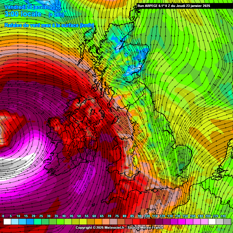
Anyway, back to the modelling - there's little change this morning, and the ARPEGE produces even stronger winds - note the area of >240km/h winds west of Ireland, that's 149mph.

https://images.meteociel.fr/im/69/18709/arpegeuk_11_26_0ocw1.png 

UserPostedImage

I note the MetO raw now has four hours of winds in the mid to high 90s for Galway, peaking at 99mph. As the system moves eastwards the winds ease somewhat but last night's MetO chart that I posted is still much the same this morning, widespread 80s over northern England/southern Scotland.

Hopefully the wider public will take the warnings seriously up there, this is no normal winter gale.


Leysdown, north Kent
Retron
  • Retron
  • Advanced Member Topic Starter
23 January 2025 04:40:14
I was curious so looked up the Wxcharts.com version of the Arpege chart. It turns out that Friday's low peaks at a whopping 158mph over the Atlantic. Sustained winds peak at 122mph, the equivalent of a middling Cat 3 hurricane.

https://ukwct.org.uk/weather/arpege.jpg 

UserPostedImage

The follow-on low for Sunday into Monday peaks at 109mph, 81mph sustained, the equivalent of a Cat 1 hurricane:

https://ukwct.org.uk/weather/arpege2.jpg 

UserPostedImage

These are seriously strong winds, and I can't recall seeing two such strong extratropical storms like that in close succession before. That deep cold over North America moving over record-warm mid-Atlantic water is really our worst enemy when it comes to winter weather!

https://climatereanalyzer.org/clim/sst_daily/?dm_id=natlsp 


Leysdown, north Kent
Retron
  • Retron
  • Advanced Member Topic Starter
23 January 2025 05:15:00

Interesting Estofex forecast for tomorrow..

https://www.estofex.org/cgi-bin/polygon/showforecast.cgi?text=yes 

Originally Posted by: SnowyHythe(Kent) 

Now that's unusual - they're clearly eyeing up something which seems to be beyond the models' grasp at the moment. It just looks like a regular windy day down here today. We'll see, I guess, but it's tomorrow where I expect to hear reports of wild weather (given the strength of the jet, the intensity of that low etc).

As others have mentioned a couple of days ago, Monday's low also looks interesting. Yesterday we saw how the 12z MetO and 15z UKV both had a small area of 110mph winds from it in the Channel, with the other models also showing varying degrees of strong winds close to or over the south and SE. This morning's MetO high-res isn't available yet, but I'll be interested to see what it does today.


Leysdown, north Kent
doctormog
23 January 2025 05:42:15
On the subject of forecasts, the  storm has now come into the range of the shipping forecast. Shannon looks like experiencing very severe conditions. I would not like to be off parts of the west coast of Ireland tomorrow morning.

GALE WARNING

Issued: 03:53 (UTC) on Thu 23 Jan 2025

Westerly gale force 8 increasing severe gale force 9 soon, then hurricane force 12 later

WIND

West backing south, 7 to severe gale 9, becoming cyclonic storm 10 to hurricane 12 later.

SEA STATE

Very rough, becoming very high or phenomenal later.

WEATHER

Rain or squally showers.

VISIBILITY

Good, occasionally poor.


Retron
  • Retron
  • Advanced Member Topic Starter
23 January 2025 06:01:38
As you would expect there's still a bit of variation in terms of track and intensity of tomorrow's low. MetO has it a fair bit north of yesterday's output (and I would expect the UKV to follow), whereas ECM keeps the track as it was, but increases the winds. It has a max of 140mph just west of Ireland, with the west coasts there seeing 110mph winds. There are then some 80s and 90s for Northern Ireland to follow.

Further north and east, 70s look more likely, with the odd spot seeing 80s, although the T+42 chart shows 113mph winds east of Aberdeen - clearly the topography is having a moderating effect on the winds as the swathe crosses the British Isles.

https://wxcharts.com/?panel=default&model=ecmwf,ecmwf,ecmwf,ecmwf®ion=uk&chart=gustmph,850temp,wind10mmph,snowdepth&run=00&step=030&plottype=10&lat=51.398&lon=0.922&skewtstep=0 


Leysdown, north Kent
Chunky Pea
23 January 2025 07:10:19
Just an observation, but the UK Met have gust speeds here currently of about 34 knots, while the ECMWF have mean speeds of 18 knots for this moment in time.  There is barely a puff of wind outside. And looking at the two nearest met stations to me, mean speeds are ranging between 5 and 8 knots. 
Patrick,

East Galway, Ireland.

Retron
  • Retron
  • Advanced Member Topic Starter
23 January 2025 07:14:50

Just an observation, but the UK Met have gust speeds here currently of about 34 knots, while the ECMWF have mean speeds of 18 knots for this moment in time.  There is barely a puff of wind outside. And looking at the two nearest met stations to me, mean speeds are ranging between 5 and 8 knots. 

Originally Posted by: Chunky Pea 

Yes, that's quite normal at this time of day - depending on your local situation there'll be a certain threshold beyond which things kick in.

Here it's much the same, but once winds are forecast to hit 25 or so mph it starts to match what's forecast. I suspect it's something to do with the night-time boundary layer but I'm unsure of the exact mechanics.

Hope you're all prepped for the storm to come, and that you get through it without any damage.


Leysdown, north Kent
StoneCroze
23 January 2025 07:28:39
You don't see this very often in the shipping forecast. This for Shannon.

Wind

West backing south, 7 to severe gale 9, becoming cyclonic storm 10 to hurricane 12 later.

Sea state

Very rough, becoming very high or phenomenal later.


Alderney, Channel Islands. (previously known as Beaufort)
nsrobins
23 January 2025 07:36:28
As suspected UKMO senior forecasters preparing RED level warnings for issue this morning - NI, SW Scotland and possibly NW Wales. The IoM is already covered by the Irish areal coverage. 
Neil

Fareham, Hampshire 28m ASL (near estuary)

Stormchaser, Member TORRO

Fargo
23 January 2025 09:24:46
Anyone fancy an dawn foray up to the summit of Ben Nevis tomorrow?

Heavy snow / Hail

Sustained 105mph

Gust 116mph

Windchill -24°

(According to the Meto generated forecast)


West Oxfordshire 230m asl
Fargo
23 January 2025 09:27:11
Looks interesting at Loop Head lighthouse in County Clare, too. Highest lowland gust I can find at 112mph - highest lowland gust I can ever remember seeing on the Meto generated forecasts. It's dropped off a bit from 115mph this morning. Has anyone found higher?
West Oxfordshire 230m asl
Roger Parsons
23 January 2025 09:28:27
The RSPB camera at Lock of the Lowes seems to be running OK - as things progress you might like to drop in and watch the storm in action.

https://scottishwildlifetrust.org.uk/things-to-do/watch-wildlife-online/loch-of-the-lowes-webcam/ 


RogerP

West Lindsey district of Lincolnshire

Everything taken together, here in Lincolnshire are more good things than man could have had the conscience to ask.

William Cobbett, in his Rural Rides - c.1830

howham
Fargo
23 January 2025 09:52:42
Scratch that - just found a 116mph gust at Belmullet 
West Oxfordshire 230m asl
Retron
  • Retron
  • Advanced Member Topic Starter
23 January 2025 09:53:09

First red warning from METO for Northern Ireland:

https://weather.metoffice.gov.uk/warnings-and-advice/uk-warnings#?date=2025-01-24&id=e443c41c-c938-4aad-8076-9eec2ab7a3be 

Originally Posted by: howham 

"Southwesterly then westerly winds will rapidly increase from west to east during the Friday morning rush hour with peak gusts of 80-90 mph fairly widely and perhaps up to 100 mph along some exposed coasts. This brings the risk of significant disruption to transport and power supplies, as well as dangerous conditions outdoors. Winds will gradually ease from the south through Friday afternoon."

For 7 AM to 2 PM - looks like they're taking those raw charts showing 100+ pretty seriously.

Perhaps there'll be another red issued for southern Scotland/northern England a bit later on.


Leysdown, north Kent
Rob K
23 January 2025 09:53:14

The RSPB camera at Lock of the Lowes seems to be running OK - as things progress you might like to drop in and watch the storm in action.

https://scottishwildlifetrust.org.uk/things-to-do/watch-wildlife-online/loch-of-the-lowes-webcam/ 

Originally Posted by: Roger Parsons 

Anyone got any good webcam links for the west coast of Ireland? 

All looks very peaceful at the Aran Islands hotel for now.... https://www.aranislandshotel.com/#footer 


Yateley, NE Hampshire, 73m asl

"But who wants to be foretold the weather? It is bad enough when it comes, without our having the misery of knowing about it beforehand." — Jerome K. Jerome

Fargo
23 January 2025 09:58:45
https://www.outdooractive.com/en/webcams/west-ireland/webcams-in-west-ireland/231992648/ 

https://onitsurf.com/webcams/ 


West Oxfordshire 230m asl
Chunky Pea
23 January 2025 10:08:38

Here it's much the same, but once winds are forecast to hit 25 or so mph it starts to match what's forecast. I suspect it's something to do with the night-time boundary layer but I'm unsure of the exact mechanics.

Originally Posted by: Retron 

Just thinking about this a bit more, and yes, that nightime boundery layer is a thing, but I was wondering, will this be in effect tomorrow night/morning as well.  Storm is expected to peak here between around 5 to 7am, with peak gusts of between 84 and 93mph shown, at least according the to GFS00z as per XCWeather. 

I am likely being overly cynical, but I can't help but think that this storm will be a lot tamer than what is currently shown on the maps, at least for my specific location. No doubt the west coast itself will have a wild ride though, as will inland areas that have some atitude behind them. 


Patrick,

East Galway, Ireland.

johncs2016
23 January 2025 10:12:46

This just goes from bad to worse here as Edinburgh is in the red warning zone, so I'm really not looking forward to that at all.😡

I guess that this probably serves me right for moaning about the weather being boring and uninteresting here for most of the time, even on occasions when the weather is more interesting elsewhere.


The north of Edinburgh, usually always missing out on snow events which occur not just within the rest of Scotland or the UK, but also within the rest of Edinburgh.

Remove ads from site