The Weather Outlook

Remove ads from site

Retron
  • Retron
  • Advanced Member Topic Starter
Tuesday, January 21, 2025 7:51:36 AM
As there are warnings already out, I thought it would be good to have a thread for the upcoming stormy period - with strong winds more likely than not for most of us, and potentially damaging winds thrown into the mix too. Winds will pick up during Thursday as an Atlantic low approaches, heralding the end of our settled period. Friday is when the damaging winds are likely, and beyond that low pressure won't be far away with the risk of further windy spells in the following couple of weeks.

To kick things off, a look at the winds for Friday. Note that I'm using mostly using MC charts as they are archived, rather than replaced with current ones each day.

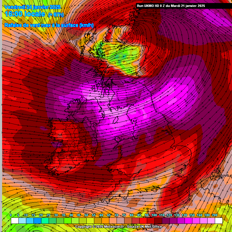
MetO has the strongest winds affecting NI, northern England and southern Scotland. It's unusual for MetO to show this sort of strength at this range - there are widespread areas of 140-150km/h winds, which is the high 80s in MPH terms.

https://images.meteociel.fr/im/95/27873/ukmohd_uk1_11_87_0ulu8.png 

UserPostedImage

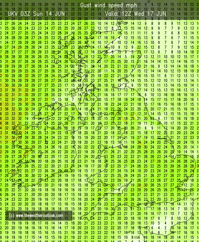
UKV is just a notch down, generally high 70s / low 80s instead, although there are the odd spots with high 80s:

UserPostedImage

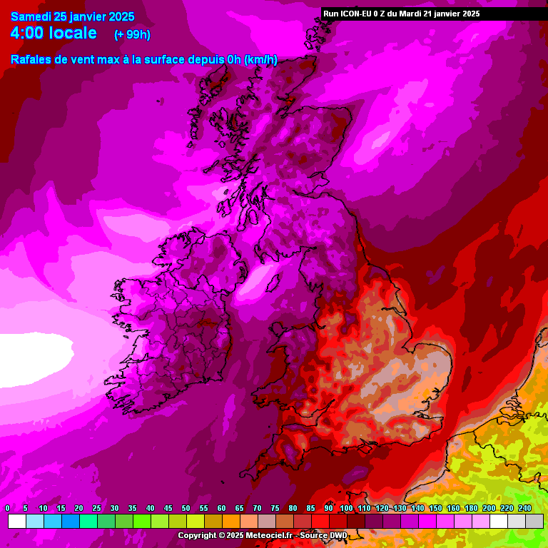
The ICON "max gust" chart for Saturday morning shows the spread of the winds - as a reminder, the burgandy is 62 or higher, then each colour above that is about 6mph, meaning again there are widespread 70s and even 80s around:

https://images.meteociel.fr/im/87/19660/iconeu_uk1_52_99_0dxv4.png 

UserPostedImage

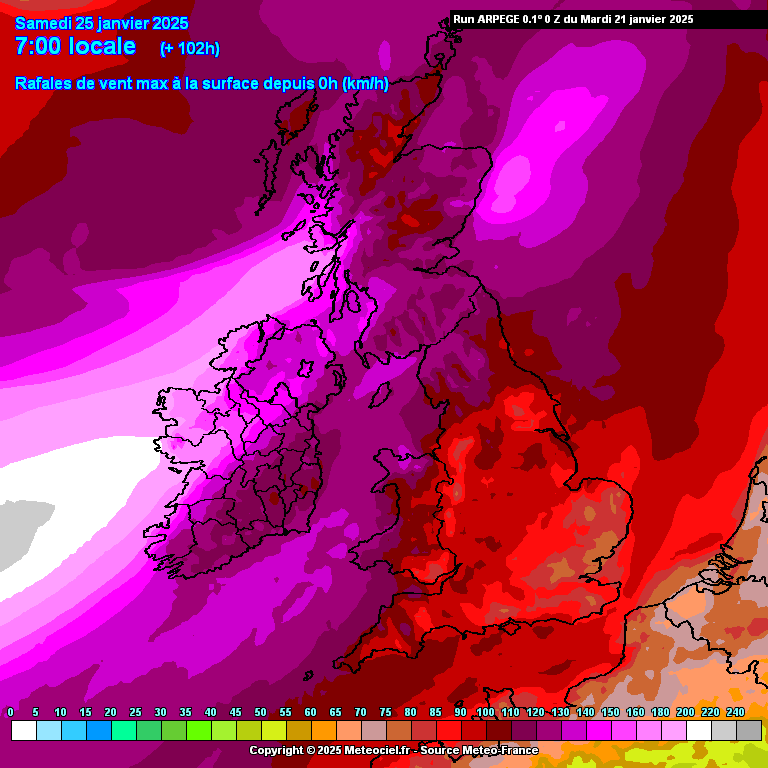
Arpege is a tad lower generally, a tapestry of 60s and low 70s, but just look at the winds over the Republic - white is 200km/h, or 124mph.

https://images.meteociel.fr/im/95/26763/arpegeuk_52_102_0mxt7.png 

UserPostedImage

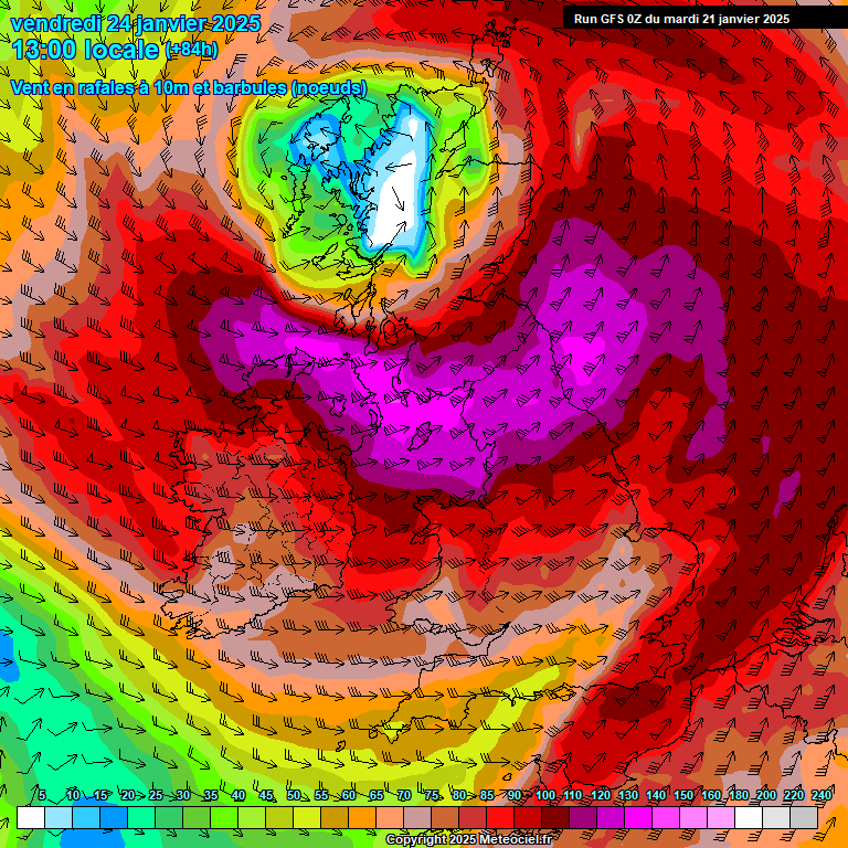
And last but not least, GFS has swathes of 70s, with the odd 80:

https://images.meteociel.fr/im/94/18995/84_289UKcbs1.GIF 

UserPostedImage

I would expect an amber to be issued later today as a result - those winds will cause damage.


Leysdown, north Kent
warrenb
Tuesday, January 21, 2025 9:14:09 AM
Are we going to get 3 named storms in a row. Friday/Saturday then Monday/Tuesday then late Tuesday.
Windy Willow
Tuesday, January 21, 2025 9:22:49 AM

Are we going to get 3 named storms in a row. Friday/Saturday then Monday/Tuesday then late Tuesday.

Originally Posted by: warrenb 

Wouldn't that be extraordinary, if it turns out like that. It's certainly looking possible.


South Holland, Lincs 5m/16ft ASL

When I saw corruption, I was forced to find truth on my own. I couldn't swallow the hypocrisy.

Barry White

It’s the end of the world as we know it (and I feel fine) - R.E.M.

Jonesy
Tuesday, January 21, 2025 10:06:06 AM
Hoping to avoid the severe wind gusts here, I remember the recent February  2022 event, lost 5 ridge tiles and 3 fence panels! That was a Friday also!
Medway Towns (Kent)

The Weather will do what it wants, when it wants, no matter what data is thrown at it !

Saint Snow
Tuesday, January 21, 2025 10:08:47 AM
UKV has gusts topping 100mph around NW Wales on Friday. At 12z, there are gusts in the mid-90's widely around Liverpool Bay  the NW England coast.

UserPostedImage


Martin

Home: St Helens (26m asl) Work: Manchester (75m asl)

A TWO addict since 14/12/01

"How can wealth persuade poverty to use its political freedom to keep wealth in power? Here lies the whole art of Conservative politics."

Aneurin Bevan

idj20
Tuesday, January 21, 2025 10:15:01 AM
Autumn resumes. 😁
Home location: Folkestone Harbour.
Rob K
Tuesday, January 21, 2025 10:42:03 AM
Big changes on the fax charts: the central pressure has been revised from 938mb to 955mb on the latest update.
Yateley, NE Hampshire, 73m asl

"But who wants to be foretold the weather? It is bad enough when it comes, without our having the misery of knowing about it beforehand." — Jerome K. Jerome

warrenb
Tuesday, January 21, 2025 11:01:58 AM

Big changes on the fax charts: the central pressure has been revised from 938mb to 955mb on the latest update.

Originally Posted by: Rob K 

It has gone from extremely windy, to incredibly windy.


idj20
Tuesday, January 21, 2025 11:04:47 AM

Big changes on the fax charts: the central pressure has been revised from 938mb to 955mb on the latest update.

Originally Posted by: Rob K 

But also further south taking the centre right through the middle of Scotland, previously it was predicted to pass by "harmlessly" off to the NW of the UK as a "classic" Icelandic depression. 

Regarding IMBY, it does look like Kent missing the worst of the storm but can still expect a short spell of strong gales, although it is looking like a daytime event rather than in the middle of the night.


Home location: Folkestone Harbour.
Retron
  • Retron
  • Advanced Member Topic Starter
Tuesday, January 21, 2025 12:29:44 PM
Storm Éowyn has now been named, and unusually that's without any amber warnings in force! The Met Office have expanded the yellow warning (which was on the amber track) and replaced the one over northern England/southern Scotland with another yellow, but a "high impact" yellow as they call it. That one's on the red track.

The text for the latter suggests they're taking the higher values from the UKV and MetO models seriously:

"a spell of very strong winds is likely, initially southeasterly before turning westerly, with peak gusts of 60-70 mph inland and 80-90 mph along some coasts and hills (perhaps even higher in a few locations). "


Leysdown, north Kent
Taylor1740
Tuesday, January 21, 2025 4:29:27 PM
Wouldn't be surprised if the storm got downgraded nearer the time and ended up much weaker than expected as the models often overplay these storms and was the case last time we had a named storm and the warnings ended up being overly prudent.
NW Leeds - 150m amsl
Jiries
Tuesday, January 21, 2025 5:58:09 PM

Wouldn't be surprised if the storm got downgraded nearer the time and ended up much weaker than expected as the models often overplay these storms and was the case last time we had a named storm and the warnings ended up being overly prudent.

Originally Posted by: Taylor1740 

Will be very boring one without snow involved but at least any rain cleared away there better chances of pleasant sunshine even if windy.

warrenb
Tuesday, January 21, 2025 6:08:59 PM
ECM is ouch.
Retron
  • Retron
  • Advanced Member Topic Starter
Tuesday, January 21, 2025 6:20:47 PM

ECM is ouch.

Originally Posted by: warrenb 

Widely in the 70s across the same swathe as shown in the 0z charts (from the other models) - but that swathe of winds hitting Ireland is truly ferocious.

https://ukwct.org.uk/weather/windy.jpg 

UserPostedImage


Leysdown, north Kent
warrenb
Tuesday, January 21, 2025 6:23:58 PM
And round 2 on Monday
Gandalf The White
Wednesday, January 22, 2025 12:58:55 AM
One of the 18z GFS perturbations has wind gusts of 85mph for the SE next Thursday - including London.  That’s above Hurricane Force 12, which is truly worrying.

Hopefully it will be toned down 


Location: South Cambridgeshire

130 metres ASL

52.0N 0.1E


Chunky Pea
Wednesday, January 22, 2025 7:09:20 AM
GFS has me down for peak gusts up to 82 knots, or about 94 mph. If this was the 70s, 80s or 90s, this would happen in a flash, but it isn't the 70s, 80s or 90s anymore, so I would expect the modern bog standard 'storm' gusts to be the usual 40kts to 60kts, if at all. 

UserPostedImage

And the same model has Salthill, just outside of Galway City, having gust speeds of 85kts. or about 97mph. 


Patrick,

East Galway, Ireland.

Tim A
Wednesday, January 22, 2025 7:44:43 AM
UserPostedImage

I would say this looks pretty bad and unusual for Northern England and the NW in particular if it comes off.  Be interesting to see whether this is overdoing it. Worth bearing in mind Liverpool Airport only reported 60mph during the last amber warning when the Merseyside Derby was cancelled which was less than some forecasts. 


Tim

NW Leeds

187m asl

 My PWS 

ballamar
Wednesday, January 22, 2025 7:57:16 AM

UserPostedImage

I would say this looks pretty bad and unusual for Northern England and the NW in particular if it comes off.  Be interesting to see whether this is overdoing it. Worth bearing in mind Liverpool Airport only reported 60mph during the last amber warning when the Merseyside Derby was cancelled which was less than some forecasts. 

Originally Posted by: Tim A 

Not a day for a gentle walk in the Lake District for sure!

Gandalf The White
Wednesday, January 22, 2025 8:02:39 AM

GFS has me down for peak gusts up to 82 knots, or about 94 mph. If this was the 70s, 80s or 90s, this would happen in a flash, but it isn't the 70s, 80s or 90s anymore, so I would expect the modern bog standard 'storm' gusts to be the usual 40kts to 60kts, if at all. 

UserPostedImage

And the same model has Salthill, just outside of Galway City, having gust speeds of 85kts. or about 97mph. 

Originally Posted by: Chunky Pea 

The weather forecast just now on BBC Radio 4 said gusts of 100-120mph on the north west coast of Ireland on Friday.  The models and that forecast suggest you’re seriously underplaying this.


Location: South Cambridgeshire

130 metres ASL

52.0N 0.1E


Chunky Pea
Wednesday, January 22, 2025 8:20:36 AM

The weather forecast just now on BBC Radio 4 said gusts of 100-120mph on the north west coast of Ireland on Friday.  The models and that forecast suggest you’re seriously underplaying this.

Originally Posted by: Gandalf The White 

Fair enough, but I'm really only talking of my own very specific inland location. Exposed NW coasts always going to be more prone. And it remains to be seen if that BBC forecast lives up, or just another overhyped forecast which has become commonplace these days. 


Patrick,

East Galway, Ireland.

Retron
  • Retron
  • Advanced Member Topic Starter
Wednesday, January 22, 2025 8:27:57 AM
Here's this morning's "max gust" chart for the ECM. Note the way the high winds "jump" west of Ireland, which is an artefact of the modelling only covering every 3 hours; in reality it'd be a smooth swathe of strong winds.

Other models such as UKV are broadly similar, and I would be surprised if we didn't have an amber for the UK (and the equivalent in Ireland) issued later this morning.

https://ukwct.org.uk/weather/windy2.jpg 

UserPostedImage


Leysdown, north Kent
LeedsLad123
Wednesday, January 22, 2025 8:44:59 AM

Wouldn't be surprised if the storm got downgraded nearer the time and ended up much weaker than expected as the models often overplay these storms and was the case last time we had a named storm and the warnings ended up being overly prudent.

Originally Posted by: Taylor1740 

I certainly hope so. I'm really sick and tired of these awful wind storms. By far my least favourite kind of weather. 


Whitkirk, Leeds - 85m ASL.
warrenb
Wednesday, January 22, 2025 9:08:57 AM
Still got my eye on Monday as well for down here.
Lionel Hutz
Wednesday, January 22, 2025 10:35:09 AM

Here's this morning's "max gust" chart for the ECM. Note the way the high winds "jump" west of Ireland, which is an artefact of the modelling only covering every 3 hours; in reality it'd be a smooth swathe of strong winds.

Other models such as UKV are broadly similar, and I would be surprised if we didn't have an amber for the UK (and the equivalent in Ireland) issued later this morning.

https://ukwct.org.uk/weather/windy2.jpg 

UserPostedImage

Originally Posted by: Retron 

There's already a MerEireann red warning for South West Ireland for Friday and an orange warning for the rest of RoI. I have a feeling that our Met hands out warnings a little more easily than yours, though.


Lionel Hutz

Nr.Waterford , S E Ireland

68m ASL


Remove ads from site