The Weather Outlook

Remove ads from site

Ally Pally Snowman
10 January 2024 16:33:56
Indeed wonderfully snowy GEM truly stunning 
Bishop's Stortford 85m ASL.
Ally Pally Snowman
10 January 2024 16:36:30
Another massive snow event on the GFS.   Incredible output this afternoon. 

https://www.wetterzentrale.de/en/topkarten.php?map=20&model=gfs&var=53&run=12&time=234&lid=OP&h=0&mv=0&tr=6#mapref 


Bishop's Stortford 85m ASL.
Jiries
10 January 2024 16:38:14

Massive Midlands snow event back on. Met office seem more confident today so not surprised to see GFS bring it back.

https://www.wetterzentrale.de/en/topkarten.php?map=20&model=gfs&var=25&run=12&time=192&lid=OP&h=0&mv=0&tr=3#mapref 


Originally Posted by: Ally Pally Snowman 

Whatever happen I am more keen to see tempeatures being in proper subzero for any snowy events and near or at -10C at nights which is absolutely more fun and beautiful Alpine scenery.   No fun when temperatures are floating less cold at 1C to 4C and 0 to 2C at nights like recent cold snowy spells.

White Meadows
10 January 2024 16:41:13
Potentially very soggy south of the M4, yet again. 


Whiteout
10 January 2024 16:48:49
Not long before the fax charts come into range....
Home/Work - Dartmoor

240m/785 ft asl

Ally Pally Snowman
10 January 2024 16:48:56
GEM is insane after covering most of the UK in snow it ends like this. 1947 esque.

https://www.wetterzentrale.de/en/topkarten.php?map=1&model=gem&var=1&run=12&time=240&lid=OP&h=0&mv=0&tr=6#mapref 


Bishop's Stortford 85m ASL.
Whiteout
10 January 2024 16:56:33
Wow, Met 168 shows the Low heading straight into France lol, that's cleared that up then lol


Home/Work - Dartmoor

240m/785 ft asl

Retron
10 January 2024 16:57:16
That GFS 12z has to be one of the worst runs I've seen in recent times - aside from high winds, I can't think of much worse than this, really! Just under an inch of rain, and 2 or 3 degrees above freezing. Awful.

You can see, though, where the disruptive potential comes from... as some places would be getting close to a foot of snow from that!

https://ukwct.org.uk/weather/rain.jpg 

UserPostedImage


Leysdown, north Kent
Ally Pally Snowman
10 January 2024 17:02:02

Wow, Met 168 shows the Low heading straight into France lol, that's cleared that up then lol


Originally Posted by: Whiteout 

It wouldn't surprise me if it ends up a south of the M4 event . You could be the sweet spot.


Bishop's Stortford 85m ASL.
ballamar
10 January 2024 17:17:48

That GFS 12z has to be one of the worst runs I've seen in recent times - aside from high winds, I can't think of much worse than this, really! Just under an inch of rain, and 2 or 3 degrees above freezing. Awful.

You can see, though, where the disruptive potential comes from... as some places would be getting close to a foot of snow from that!

https://ukwct.org.uk/weather/rain.jpg 

UserPostedImage

Originally Posted by: Retron 

Painful to see DP’s that high on an easterly! Plenty of time to change for the better 

Rob K
10 January 2024 17:31:42
Daytime highs of -5C across the Midlands on the 19t according to GFS. A hundred miles or so of adjustment south will do the trick please.
Yateley, NE Hampshire, 73m asl

"But who wants to be foretold the weather? It is bad enough when it comes, without our having the misery of knowing about it beforehand." — Jerome K. Jerome

Retron
10 January 2024 17:34:44
Far more scatter in the 12z GEFS short ensembles for London, FWIW - after a relatively tight cluster in the 6z. It'd be nice to get this pinned down one way or the other!
Leysdown, north Kent
nsrobins
10 January 2024 17:35:47
If the 12Z GFS OP isn't one of the mildest options at 180hrs, if not the mildest (London) I’ll eat my rose-tinted spectacles in a Jam tomorrow sandwich.
Neil

Fareham, Hampshire 28m ASL (near estuary)

Stormchaser, Member TORRO

doctormog
10 January 2024 17:40:15

If the 12Z GFS OP isn't one of the mildest options at 180hrs, if not the mildest (London) I’ll eat my rose-tinted spectacles in a Jam tomorrow sandwich.

Originally Posted by: nsrobins 

I think your hat is safe.


ballamar
10 January 2024 17:40:20
GEFS flipping quite wildly at the moment - goes to show the uncertainty. See what ECM throws out - no middle ground at the moment!
White Meadows
10 January 2024 17:44:24
Another massive Scandy HP at the end. That’s 3 or 4 runs on the trot now.

New trend emerging. 


Retron
10 January 2024 17:48:10

GEFS flipping quite wildly at the moment - goes to show the uncertainty. See what ECM throws out - no middle ground at the moment!

Originally Posted by: ballamar 

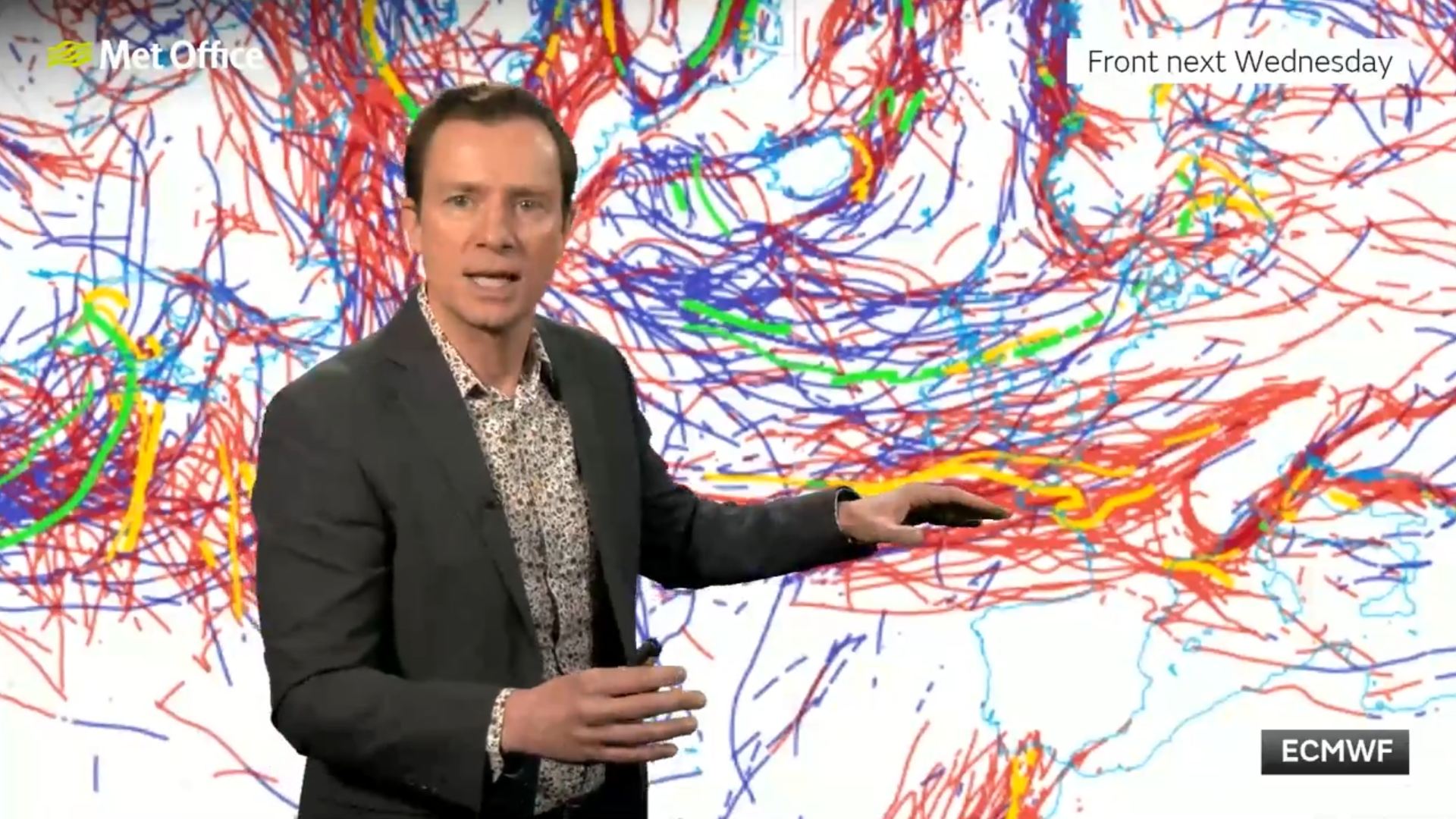
Here's an interesting chart from the ECM's 0z run - apparently the red lines show the various positioning of the warm front next Wednesday, one line per ensemble member! Can't say I've seen that sort of chart before, normally the spaghetti plots are for 850s, or 500hPa heights or similar.

It's from the MetO 10-day trend video, the one where Alex Deakin mentions that there could be some "dumps" for Scotland!

The link for that is on the Media thread if you've not already seen it.

https://ukwct.org.uk/weather/warmfront.jpg
UserPostedImage 


Leysdown, north Kent
Ally Pally Snowman
10 January 2024 17:49:58

Another massive Scandy HP at the end. That’s 3 or 4 runs on the trot now.

New trend emerging. 


Originally Posted by: White Meadows 

We know GFS can be very good at spotting pattern changes way out. So 4 Ops in a row is a great sign.


Bishop's Stortford 85m ASL.
Retron
10 January 2024 17:52:22
...and the MetO's view of the most likely snow area, taking all the models and their ensembles into consideration? Along the M4 corridor! (And also here, but I have to admit that sounds dodgy to me...)

https://ukwct.org.uk/weather/snowens.jpg 

UserPostedImage


Leysdown, north Kent
ballamar
10 January 2024 17:55:57

...and the MetO's view of the most likely snow area, taking all the models and their ensembles into consideration? Along the M4 corridor! (And also here, but I have to admit that sounds dodgy to me...)

https://ukwct.org.uk/weather/snowens.jpg 

UserPostedImage

Originally Posted by: Retron 

living where we do close to the coast this shocks me as well - perhaps it will come off this time

Rob K
10 January 2024 18:03:56

Here's an interesting chart from the ECM's 0z run - apparently the red lines show the various positioning of the warm front next Wednesday, one line per ensemble member! Can't say I've seen that sort of chart before, normally the spaghetti plots are for 850s, or 500hPa heights or similar.

It's from the MetO 10-day trend video, the one where Alex Deakin mentions that there could be some "dumps" for Scotland!

The link for that is on the Media thread if you've not already seen it.

https://ukwct.org.uk/weather/warmfront.jpg

UserPostedImage 

Originally Posted by: Retron 

For all that we moan about the models, the fact that we can even say that there is going to be a front somewhere in our vicinity in a whole week's time is actually pretty remarkable when you think about how far the atmosphere moves in a week.


Yateley, NE Hampshire, 73m asl

"But who wants to be foretold the weather? It is bad enough when it comes, without our having the misery of knowing about it beforehand." — Jerome K. Jerome

MRayner
10 January 2024 18:06:59

Not long before the fax charts come into range....

Originally Posted by: Whiteout 

Good point, they tend to be the guide of what’s really going to happen !!


Location Whisky 🥃 country, Cragganmore ,Moray, 440 AMSL

Retron
10 January 2024 18:07:28

For all that we moan about the models, the fact that we can even say that there is going to be a front somewhere in our vicinity in a whole week's time is actually pretty remarkable when you think about how far the atmosphere moves in a week.

Originally Posted by: Rob K 

It does almost seem like magic to me - a bit like when you know there are gales coming in several days' time, when the low responsible is still a tiny wave over the Midwest! (That happened with the last storm system, and the forecasts were pretty good for that).

It's also nice to get a glimpse of some of the extra stuff that's for internal use only at the MetO. I had no idea they even had frontal charts like that, it's impressive to see!


Leysdown, north Kent
fullybhoy
10 January 2024 18:20:58
 I kinda echo saint’s fears about this part of Scotland……….far too far north obviously for these potential low pressure systems pushing in, and as usual too sheltered for anything else coming from the north……..
Alan

Glasgow 165m/asl

Ally Pally Snowman
10 January 2024 18:30:50
Ecm looks like it's going down the high impact snow route at 144h
Bishop's Stortford 85m ASL.

Remove ads from site