The Weather Outlook

Remove ads from site

Brian Gaze
01 January 2024 16:31:43

Well you learn something everyday i had no idea of that. 

Originally Posted by: Ally Pally Snowman 

It's the same with the UK Met suite.


Brian Gaze

Berkhamsted

TWO Buzz - get the latest news and views 

"I'm not socialist, I know that. I don't believe in sharing my money." - Gary Numan

Retron
01 January 2024 16:32:03

Well Gerrit certainly should have been Amber . Madness.  

Originally Posted by: Ally Pally Snowman 

Agreed on that one, and not really sure why it wasn't upgraded - even a last-minute amber would have been better than nothing.


Leysdown, north Kent
David M Porter
01 January 2024 16:39:55

Well Gerrit certainly should have been Amber . Madness.  

Originally Posted by: Ally Pally Snowman 

I wonder if it was simply a case of Gerrit being a bit stronger than was originally thought, a bit like happened with the infamous October '87 storm?


Lenzie, Glasgow

"A body of men holding themselves accountable to nobody ought not to be trusted by anybody." – Thomas Paine

Caz
  • Caz
  • Advanced Member
01 January 2024 16:47:40
Yellow warning for heavy rain here tonight and up to 9pm tomorrow night. Again!  
Market Warsop, North Nottinghamshire.

Join the fun and banter of the monthly CET competition.

Retron
01 January 2024 16:51:57

It's the same with the UK Met suite.

Originally Posted by: Brian Gaze 

Don't forget ICON (from the German DWD) containing bits of ECM code - it's not surprising, really, as I'm sure all the European agencies will maintain a very close working relationship with each other.

Incidentally, while playing Portal with RTX earlier, I mused on how a gaming graphics card like mine is now being used to run weather models - work is underway on moving bits of ICON to GPU processing, and I'm sure the same is going on with the other models too. Who'd have imagined all those years ago that us PC gamers would have ended up with the equivalent of a turn-of-the-century supercomputer on our desk?


Leysdown, north Kent
Retron
01 January 2024 17:16:57
...and the 12z hi-res MetO run downgrades the wind. It really is very unusual to have such disagreement within 36 hours, but there will be no complaints here if the MetO has "nailed it", so to speak.

https://images.meteociel.fr/im/50/2245/ukmohd_uk1_52_41_0fng7.png 

UserPostedImage


Leysdown, north Kent
Brian Gaze
01 January 2024 17:27:14

...and the 12z hi-res MetO run downgrades the wind. It really is very unusual to have such disagreement within 36 hours, but there will be no complaints here if the MetO has "nailed it", so to speak.

https://images.meteociel.fr/im/50/2245/ukmohd_uk1_52_41_0fng7.png 

UserPostedImage

Originally Posted by: Retron 

Yes, the differences are enormous. UKM has gusts of 50mph to 55mph in East Anglia, but significantly lower than some of the other models.


Brian Gaze

Berkhamsted

TWO Buzz - get the latest news and views 

"I'm not socialist, I know that. I don't believe in sharing my money." - Gary Numan

Brian Gaze
01 January 2024 17:29:21
UKM Global gusts 

https://www.theweatheroutlook.com/twodata/ukmetuk.aspx?run=12&charthour=22&chartname=wind_gust&chartregion=uk-region&charttag=Wind%20gust%20mph 

UserPostedImage

UserPostedImage


Brian Gaze

Berkhamsted

TWO Buzz - get the latest news and views 

"I'm not socialist, I know that. I don't believe in sharing my money." - Gary Numan

Gusty
01 January 2024 17:53:12
The far SE corner is in with a shout of something wintry 7-9th January as we pull in a convective looking NE'ly before the High settles over. I note with interest the 850Hpa's have dropped down a notch with a little more longevity today. They've edged towards the ECM that have been consistently a little colder.

Fine margins between the usual -6 to -7c rain and sleet fest to something far more interesting in that -8c to -9c range.

https://www.wetterzentrale.de/en/show_diagrams.php?geoid=49909&model=gfs&var=2&run=12&lid=ENS&bw= 

https://www.wetterzentrale.de/en/show_diagrams.php?geoid=49909&model=ecm&var=2&run=6&lid=ENS&bw= 


Steve - Folkestone, Kent

Current conditions from my Davis Vantage Vue

https://www.wunderground.com/dashboard/pws/IFOLKE11 

Join Kent Weather on Facebook.

https://www.facebook.com/stevewall69/ 


Retron
01 January 2024 17:57:03
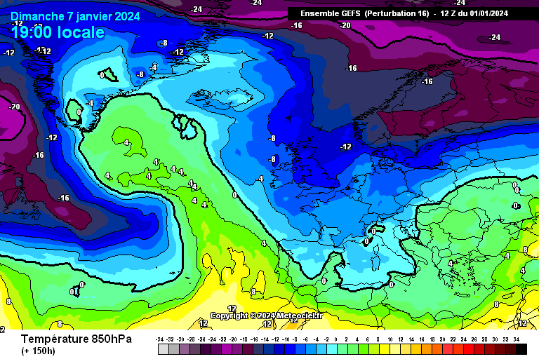
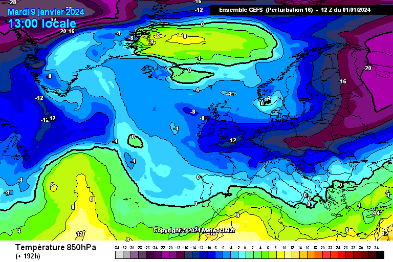
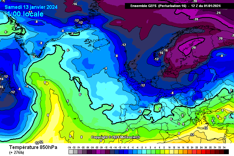
Run of the day goes to ptb 16 of the 12z GEFS.

Starts with a northerly on day 6:

https://images.meteociel.fr/im/79/19415/gens_16_0_150pwy5.png 
UserPostedImage

Becomes an easterly by day 8:

https://images.meteociel.fr/im/19/13687/gens_16_0_192xsd7.png 
UserPostedImage

...and then as that cold wedge of air swiftly "poofs", it gets replaced by another northerly by day 12:

https://images.meteociel.fr/im/32/21988/gens_16_0_276qob5.png 
UserPostedImage

Remarkable stuff, and it's what you'd want to see if a prolonged, 80s-style cold spell is what you're after.

EDIT: Note how similar the day 6 pattern is to the day 12, only everything's moved westwards a bit. This is what I meant the other day when I mentioned a self-reinforcing pattern, it's the cold equivalent of a Bartlett setup (whereby one high moves away, only to be replaced by another in more or less the same position).


Leysdown, north Kent
The Beast from the East
01 January 2024 18:24:52

Run of the day goes to ptb 16 of the 12z GEFS.

Starts with a northerly on day 6:

https://images.meteociel.fr/im/79/19415/gens_16_0_150pwy5.png 

UserPostedImage

Becomes an easterly by day 8:

https://images.meteociel.fr/im/19/13687/gens_16_0_192xsd7.png 

UserPostedImage

...and then as that cold wedge of air swiftly "poofs", it gets replaced by another northerly by day 12:

https://images.meteociel.fr/im/32/21988/gens_16_0_276qob5.png 

UserPostedImage

Remarkable stuff, and it's what you'd want to see if a prolonged, 80s-style cold spell is what you're after.

EDIT: Note how similar the day 6 pattern is to the day 12, only everything's moved westwards a bit. This is what I meant the other day when I mentioned a self-reinforcing pattern, it's the cold equivalent of a Bartlett setup (whereby one high moves away, only to be replaced by another in more or less the same position).

Originally Posted by: Retron 

This is the meteorological equivalent of hardcore porn. But like porn will remain a fantasy! 


Purley, Surrey, 70m ASL

"We have some alternative facts for you"

Kelly-Ann Conway - former special adviser to the President

doctormog
01 January 2024 18:30:47
Ally Pally Snowman
01 January 2024 18:35:05
Ecm is a beauty
Bishop's Stortford 85m ASL.
Karl Guille
01 January 2024 18:38:46
ECM positioning the high much better on the 12z with a decent easterly feed for many.
St. Sampson

Guernsey

Gandalf The White
01 January 2024 18:42:15

ECM positioning the high much better on the 12z with a decent easterly feed for many.

Originally Posted by: Karl Guille 

Yes, the WAA is drawn that little but further north on this run.  Very cold air stream into the SE.

Pretty bitter easterly for the south at T+192. I think that’s ice day territory.


Location: South Cambridgeshire

130 metres ASL

52.0N 0.1E


Ally Pally Snowman
01 January 2024 18:43:45

ECM positioning the high much better on the 12z with a decent easterly feed for many.

Originally Posted by: Karl Guille 

Indeed by 192h its a proper Thames streamer job. -11c 850s . A stunner.🤩


Bishop's Stortford 85m ASL.
Tim A
01 January 2024 18:54:48
It's a great run and gives us some hope. Need other models to trend the same way now.  
Tim

NW Leeds

187m asl

 My PWS 

White Meadows
01 January 2024 20:26:29
Still not spectacular but could well be the first bite of the cherry.. before something special after mid month:

https://www.wetterzentrale.de/en/show_diagrams.php?geoid=49909&model=ecm&var=2&run=12&lid=ENS&bw=1 


The Beast from the East
01 January 2024 20:31:41
ECM 10 day mean looks very good. Must be some belters in the ensembles


Purley, Surrey, 70m ASL

"We have some alternative facts for you"

Kelly-Ann Conway - former special adviser to the President

Polar Low
01 January 2024 20:43:09
Ecm control looks better than the opp n/e attack very strong Greenland high and  low just east of Denmark

Very cold, snow showers becoming heavy and prolonged especially east with certain drifting 

mean as Geoff has said similar attack around 14th


ballamar
01 January 2024 20:45:27

Still not spectacular but could well be the first bite of the cherry.. before something special after mid month:

https://www.wetterzentrale.de/en/show_diagrams.php?geoid=49909&model=ecm&var=2&run=12&lid=ENS&bw=1 


Originally Posted by: White Meadows 

the 2m temps begin to give a better representation with the HP being dominant

Polar Low
01 January 2024 21:01:33
Control ends 16th snow showers continue most of U.K. no end in sight,

Europe locked in very cold. Severe Cold N/E sub -20 850

Best run I’ve seen since 87 what on earth can go wrong? 

Brian Gaze
01 January 2024 21:32:14
The ECM stamps look solid at t+7 days.  In the longer term things become more mixed as expected, but there are plenty of cookie cutters in the mix for sure. It's going to be absolutely fascinating seeing how this all plays out. (I'm 100% serious) Can we get a prolonged spell of really cold weather which will pull the Jan and Feb CET 2C or more below the 30 year norm? Given the background warmth through 2023 that would be extraordinary.

https://www.theweatheroutlook.com/twodata/gefs.aspx 


Brian Gaze

Berkhamsted

TWO Buzz - get the latest news and views 

"I'm not socialist, I know that. I don't believe in sharing my money." - Gary Numan

MBrothers
01 January 2024 22:03:32
Omg I don’t get interested in cold spells as they often disappear just like that but when u see Brian getting interested then it ticks ups a gear . 

Remove ads from site