The Weather Outlook

Remove ads from site

David M Porter
30 December 2023 19:46:40

More like the sort of output I would rather be seeing during the summer, although that would be a drier outcome in the end which would at least give us a bit of a break from all of the rain which we've getting just recently.


Originally Posted by: johncs2016 

Absolutely. I think a drier spell is needed rather more than a wintry one at the moment. 🙂


Lenzie, Glasgow

"A body of men holding themselves accountable to nobody ought not to be trusted by anybody." – Thomas Paine

ballamar
30 December 2023 21:50:02
Pub run spectacular with 20+ runs sub -10 please
jhall
30 December 2023 21:58:32

Pub run spectacular with 20+ runs sub -10 please

Originally Posted by: ballamar 

I was getting excited until I reached the last word and realised it was a request rather than a statement of fact. 🙂


Cranleigh, Surrey
Saint Snow
30 December 2023 22:27:23

Absolutely. I think a drier spell is needed rather more than a wintry one at the moment. 🙂

Originally Posted by: David M Porter 

Wash your mouth out, sonny boy!!

If the ground is frozen and topped with 30cm of snow, you won't care about mud.

😀

(Just once, I want a nationwide fall of super-deep snow, which paralyses the country for a couple of months weeks)


Martin

Home: St Helens (26m asl) Work: Manchester (75m asl)

A TWO addict since 14/12/01

"How can wealth persuade poverty to use its political freedom to keep wealth in power? Here lies the whole art of Conservative politics."

Aneurin Bevan

johncs2016
30 December 2023 22:59:52

Wash your mouth out, sonny boy!!

If the ground is frozen and topped with 30cm of snow, you won't care about mud.

😀

(Just once, I want a nationwide fall of super-deep snow, which paralyses the country for a couple of months weeks)


Originally Posted by: Saint Snow 

Regardless of what the model output is like and regardless of what the actual outcome of that is though, we also know that Aberdeen Richard will of course, no doubt still manage to find something to moan about which he isn't happy with.🤣


The north of Edinburgh, usually always missing out on snow events which occur not just within the rest of Scotland or the UK, but also within the rest of Edinburgh.

The Beast from the East
30 December 2023 23:03:55

Regardless of what the model output is like and regardless of what the actual outcome of that is though, we also know that Aberdeen Richard will of course, no doubt still manage to find something to moan about which he isn't happy with.🤣

Originally Posted by: johncs2016 

a big cloudy dirty high with returning Atlantic air mass now looking the most likely outcome. 


Purley, Surrey, 70m ASL

"We have some alternative facts for you"

Kelly-Ann Conway - former special adviser to the President

Quantum
30 December 2023 23:18:21
Just a quick thing to point out. Scandanavia is likely going to see record cold over the next week. The baltic sea ice is also crazy high for the time of year. If the winds go north easterly (which they still might) oh boy....


25/26 (850hpa temp) 11 days snow/sleet falling

18/11 (-4) 19/11 (-6) 20/11 (-6) 01/01 (-7) 04/01 (-10) 10/01 (-7) 11/01 (-3) 30/01 (-1) 13/02 (-6) 15/02 (-4) 18/02 (-6)

24/25 10d

18/11 (-6) 19/11 (-6) 23/11 (-2) 22/12 (-5) 04/01 (-5) 05/01 (0)14/02 (0) 15/02 (0)12/03 (-6) 13/03 (-6)

23/24 8d

29/11 (-6) 30/11 (-6) 02/12 (-5) 03/12 (-5) 04/12 (-3) 16/01 (-3) 18/01 (-8)08/02 (-5)

22/23 7d

18/12 (-1)06/03 (-6) 08/03 (-8) 09/03 (-6) 10/03 (-8) 11/03 (-5) 14/03 (-6)

21/22 12d

Gandalf The White
31 December 2023 00:20:16

Wash your mouth out, sonny boy!!

If the ground is frozen and topped with 30cm of snow, you won't care about mud.

😀

(Just once, I want a nationwide fall of super-deep snow, which paralyses the country for a couple of months weeks)


Originally Posted by: Saint Snow 

…..until it all melts, which it must.

😉🤣


Location: South Cambridgeshire

130 metres ASL

52.0N 0.1E


Ally Pally Snowman
31 December 2023 06:40:46
After a poor GEM and GFS , ECM produces the goods -10c 850s on an easterly just a week away.

https://www.wetterzentrale.de/en/topkarten.php?map=1&model=ecm&var=2&run=0&time=168&lid=OP&h=0&mv=0&tr=24#mapref 


Bishop's Stortford 85m ASL.
CField
31 December 2023 06:40:48
As with yesterday a good looking ECM 0Z run....with those uppers and wind direction  East Kent looks set for a fair dumping...Big differences now showing with the models...
Favourite snowstorm

Famous channel low

Dec 31st 1978

Hastings East Sussex

Foot of level snow severe drifting

Next day max temp -4 degrees Celsius

Retron
31 December 2023 06:44:39
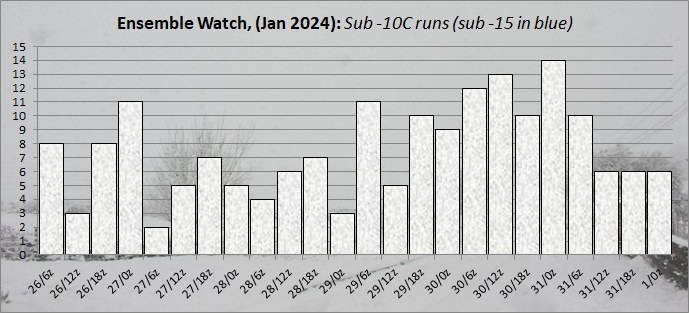
Today's ensemble watch is the coldest set yet.

The upcoming pattern change is a little clearer today. It looks like pressure will rise in the vicinity of the UK at the end of the week, which can only be a good thing for those who are fed up with wind and rain. In the process of doing so, there will be some cold air pushed south, clipping Scotland and then largely passing to the east. This should, however, help to ensure there are some clear skies under the high, leading to widespread frost (as shown on the UK text outlook).

Beyond that the high will decline, as they usually do, but then thanks to the upstream pattern being favourable it'll either be pulled westwards, or a new high will form to the west. This will then pull another pulse of cold air southwards and, at the moment, the ensembles favour that to be a good deal colder than next weekend's effort. It's from this point onwards that the chances of snow begin to rise, moreso if the ridge ends up far enough north and east to engage the exceptionally cold air over Scandinavia.

That's one of the scenarios, anyway. Another scenario is that after next weekend's high declines, the ridging to the west fails to build much, meaning less (or no) cold air is pushed over the UK and we sink back into the status quo. At the moment, though, that's the lesser chance - the majority of the output is showing a colder, more settled interlude on the way. Whether that then extends to a cold spell remains to be seen, but in

the meantime I'm just grateful to see the end of this relentless zonality coming into view.

https://ukwct.org.uk/weather/enswatch.jpg?31 
UserPostedImage


Leysdown, north Kent
Retron
31 December 2023 06:48:35

As with yesterday a good looking ECM 0Z run....with those uppers and wind direction  East Kent looks set for a fair dumping...Big differences now showing with the models...

Originally Posted by: CField 

I hadn't seen that as of writing my post above - it is indeed an impressive ECM, with this weekend's high managing to ridge far enough NE to dislodge some of that Scandinavian cold pool. That would certainly bring a chill feel to things, even if (compared to the other models) it's very much on the colder side of the consensus.


Leysdown, north Kent
Heavy Weather 2013
31 December 2023 07:24:13

I hadn't seen that as of writing my post above - it is indeed an impressive ECM, with this weekend's high managing to ridge far enough NE to dislodge some of that Scandinavian cold pool. That would certainly bring a chill feel to things, even if (compared to the other models) it's very much on the colder side of the consensus.


Originally Posted by: Retron 

That Sunday ECM chart reminds me of the February 2009 snowstorm we had in the SE


Mark

Beckton, E London

Less than 500m from the end of London City Airport runway.

DEW
  • DEW
  • Advanced Member
31 December 2023 07:32:38
WX temps - the deep cold over Russia is holding its position in week 1 with quite a steep gradient to Poland which is still above freezing but in week 2 (like the forecast from 2 days back) the floodgates open and freezing weather spreads all the way down to the Pyrenees. A noticeable cooling for Britain but not freezing. Pptn heavy from the Atlantic across all NW Europe incl Britain in week 1 and as per yesterday's forecast this fades away, not entirely dry anywhere but any heavy rain in the eastern Med.

GFS Op - A messy picture of LP this week, currently 980mb Isle of Man, but tending to move north while at the same time linking with other LP in N Atlantic (but FAX shows fronts often affecting the south) . From Sat 6th a ridge of HP appears over Britain with some N-lies down the E Coast, consolidating into a centre 1040mb N France Thu 11th. That centre moves to the W of Ireland allowing a brief NE-ly spell for England Mon 15th before the HP moves back off the Atlantic.

ECM - the ridge appears on Sat 6th but consolidates N-wards, 1040mb N Scotland Mon 8th with E-ly or NE-ly for England for a couple of days until pressure rises there too.

GEFS - heavy rain esp in S and also in the S mild until Thu 4th, then mostly dry and cold. Mean temp 4 or 5 C below norm with good agreement of ens members by Mon 8th, continuing cold in most runs through to Tue 16th, relatively few (though these include op) getting above seasonal norm. Snow row figures moderately good for Inverness, even a small uptick for London.


I can calculate the movements of stars, but not the madness of men - Isaac Newton

Chichester 12m asl

Retron
31 December 2023 07:34:46

That Sunday ECM chart reminds me of the February 2009 snowstorm we had in the SE


Originally Posted by: Heavy Weather 2013 

It's actually not as impressive if you bring up the precip type charts - it'd be a sleety mix, sadly.

https://meteologix.com/uk/model-charts/euro/united-kingdom/significant-weather/20240107-0600z.html 


Leysdown, north Kent
Jiries
31 December 2023 07:41:44

That Sunday ECM chart reminds me of the February 2009 snowstorm we had in the SE


Originally Posted by: Heavy Weather 2013 

I remember that very well and hope this time if any cold set up occur I desire for proper ice days and snowy events. 

Gusty
31 December 2023 08:33:20

I remember that very well and hope this time if any cold set up occur I desire for proper ice days and snowy events. 

Originally Posted by: Jiries 

I'll stop you there Jiries lol...this is where you go wrong time and time again.

ECM mean at 168 hours.

https://www.wetterzentrale.de/en/topkarten.php?map=1&model=ecm&var=2&time=168&run=0&lid=AVG&h=0&mv=0&tr=24 

GFS mean at 168 hours

https://www.wetterzentrale.de/en/topkarten.php?map=1&model=gfs&var=2&time=168&run=0&lid=AVG&h=0&tr=24&mv=0 

For now its looking like a significantly drier and settled period of weather. Coldest uppers towards the SE corner.


Steve - Folkestone, Kent

Current conditions from my Davis Vantage Vue

https://www.wunderground.com/dashboard/pws/IFOLKE11 

Join Kent Weather on Facebook.

https://www.facebook.com/stevewall69/ 


warrenb
31 December 2023 09:17:44
I am going to plump for a Retron (Darren) double dipper. It just has a feel of an initial cold push followed by a relaxation then the beast. I remember that is how 1979 started down here. We had some sharp frosts and few flurries then it warmed up for a week or so then the beast arrived.
The Beast from the East
31 December 2023 09:32:56

I am going to plump for a Retron (Darren) double dipper. It just has a feel of an initial cold push followed by a relaxation then the beast. I remember that is how 1979 started down here. We had some sharp frosts and few flurries then it warmed up for a week or so then the beast arrived.

Originally Posted by: warrenb 

On the sauce already! 

Sadly this isnt the 80s or even 90s anymore, normal rules no longer apply. The jet will never allowing blocking in the right place unless there is a massive SSW to disrupt things.  But at least it looks dryer and more settled. My daffs are already coming up, would be nice to see the earliest ever sprouting, 


Purley, Surrey, 70m ASL

"We have some alternative facts for you"

Kelly-Ann Conway - former special adviser to the President

Ally Pally Snowman
31 December 2023 09:45:03
Lots of "not quite" charts atm. The kind of charts that could upgrade significantly quite quickly though.
Bishop's Stortford 85m ASL.
jhall
31 December 2023 09:55:09

As with yesterday a good looking ECM 0Z run....with those uppers and wind direction  East Kent looks set for a fair dumping...Big differences now showing with the models...

Originally Posted by: CField 

Yes, there's a huge difference as close as 5 days out between the midnight GFS and ECM ops. GFS does get it right in the end for cold lovers, but it makes about three attempts at bringing in proper cold before it finally succeeds deep into FI.


Cranleigh, Surrey
Ally Pally Snowman
31 December 2023 10:01:54
Not quite January 1795 yet but not bad . That's a decent cold spell for these days 3c ish maxes for 9+ days.

https://www.wetterzentrale.de/en/show_diagrams.php?geoid=50893&model=ecm&var=5&run=0&lid=ENS&bw=1 


Bishop's Stortford 85m ASL.
warrenb
31 December 2023 10:15:38
Wow you have a good memory
Caz
  • Caz
  • Advanced Member
31 December 2023 10:18:36

Wow you have a good memory

Originally Posted by: warrenb 

😂 Love these little typos!  
Market Warsop, North Nottinghamshire.

Join the fun and banter of the monthly CET competition.

ballamar
31 December 2023 10:19:45
Any stagnating air at the beginning of January can become a lot colder than the current forecast maximums with freezing fog becoming an issue. Could start to see ice days in prone spots - interesting outlook

Remove ads from site