The Weather Outlook

Remove ads from site

scillydave
31 October 2023 10:41:57
I'd expect the areas currently yellow to turn amber late tonight / early tomorrow morning and the Amber warnings to go Red at the same time.

One to buckle up for I think. 

As the old boys on Scilly would say "it's coming fit to blow".


Currently living at roughly 65m asl North of Cowbridge in the Vale of Glamorgan.

Formerly of, Birdlip, highest village in the Cotswolds and snow heaven in winter; Hawkinge in Kent - roof of the South downs and Isles of Scilly, paradise in the UK.

Gusty
31 October 2023 10:54:19
How's the 6z icon looking ?

We need that fella to calm things down a bit.


Steve - Folkestone, Kent

Current conditions from my Davis Vantage Vue

https://www.wunderground.com/dashboard/pws/IFOLKE11 

Join Kent Weather on Facebook.

https://www.facebook.com/stevewall69/ 


Heavy Weather 2013
31 October 2023 10:56:06

To emphasise the uncertainties, GFS and ECM have both undersampled (00Z input) the jet strength above the nascent low that will become Ciaran. They both have it at about 165kn when in reality from a sounding (Maine) it was over 180kn. 

There is every possibility the low will track left of model on approach - I can’t emphasize the risks enough should this happen.

Originally Posted by: nsrobins 

Didn’t this also happen yesterday morning and then for the 12z it corrected north. Now it’s corrected south again. I wonder if as a result we will see a correction north again this evening for the 12z.


Mark

Beckton, E London

Less than 500m from the end of London City Airport runway.

SnowyHythe(Kent)
31 October 2023 10:58:08
A tad further south but not enough to spare the coastal areas of the great garden of England..
Retron
31 October 2023 11:01:46

How's the 6z icon looking ?

Originally Posted by: Gusty 

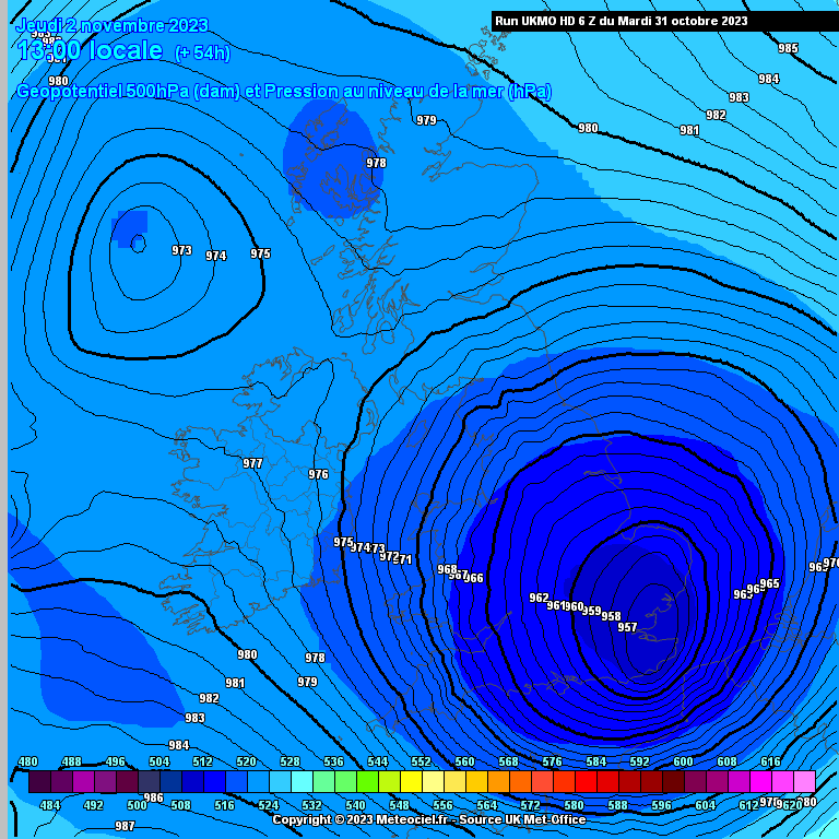
I posted earlier - it's okay. Arpege is still a windfest, and the 6z GEFS are as usual a very mixed bunch. Not much support for a southerly-tracking low as per ICON, UKV and 0z MetO, mind you...

The 6z MetO has the eye right over Sheppey, which would be a novelty... and it's a further move in the right direction.

https://images.meteociel.fr/im/85/12200/ukmohd_uk1_2_54_0jtc6.png 
UserPostedImage

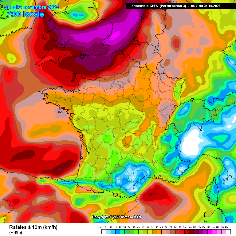
As for the 6z GEFS, they generally back the op but there are some noteworthy outliers. Nothing quite as far south as that MetO chart, but some not far off. And on the other end of the scale, some deepen the low much more - and take it, and the band of exceptional winds, much further north. Southern England would see widespread destruction in the process, mind you, so it's not good news for us down here if that happens.

https://images.meteociel.fr/im/30/8227/gensfr_3_8_48nzm7.png 
UserPostedImage


Leysdown, north Kent
DEW
  • DEW
  • Advanced Member Topic Starter
31 October 2023 11:19:39

I was going to suggest an East Kent meet up. Like old times…Perhaps not..🙈

Originally Posted by: SnowyHythe(Kent) 

Bring axes and chainsaws to clear the roads?


I can calculate the movements of stars, but not the madness of men - Isaac Newton

Chichester 12m asl

Rob K
31 October 2023 11:30:29
I've had a couple of fence posts sitting in the garden for a few weeks now, waiting to replace some rotted ones. I think it might be prudent to take the affected panels down before tomorrow night - although most forecasts don't have anything too severe this far inland.
Yateley, NE Hampshire, 73m asl

"But who wants to be foretold the weather? It is bad enough when it comes, without our having the misery of knowing about it beforehand." — Jerome K. Jerome

Rob K
31 October 2023 11:34:55
ALARO 6Z has a couple of patches of 200kph+ gusts along the Sussex coasts 🤨

https://modeles3.meteociel.fr/modeles/alaro/runs/2023103106/alaro-52-60-0.png?31-10

UserPostedImage 


Yateley, NE Hampshire, 73m asl

"But who wants to be foretold the weather? It is bad enough when it comes, without our having the misery of knowing about it beforehand." — Jerome K. Jerome

Brian Gaze
31 October 2023 11:42:45
I don't think we're out of the woods yet personally.

UserPostedImage


Brian Gaze

Berkhamsted

TWO Buzz - get the latest news and views 

"I'm not socialist, I know that. I don't believe in sharing my money." - Gary Numan

Gusty
31 October 2023 11:54:15

I posted earlier - it's okay. Arpege is still a windfest, and the 6z GEFS are as usual a very mixed bunch. Not much support for a southerly-tracking low as per ICON, UKV and 0z MetO, mind you...

The 6z MetO has the eye right over Sheppey, which would be a novelty... and it's a further move in the right direction.

https://images.meteociel.fr/im/85/12200/ukmohd_uk1_2_54_0jtc6.png 

UserPostedImage

As for the 6z GEFS, they generally back the op but there are some noteworthy outliers. Nothing quite as far south as that MetO chart, but some not far off. And on the other end of the scale, some deepen the low much more - and take it, and the band of exceptional winds, much further north. Southern England would see widespread destruction in the process, mind you, so it's not good news for us down here if that happens.

https://images.meteociel.fr/im/30/8227/gensfr_3_8_48nzm7.png 

UserPostedImage

Originally Posted by: Retron 

Thanks Darren.

70-75mph we can just about live with here on the coast. 80-85mph is a completely different ball game. Carnage and devastation. 


Steve - Folkestone, Kent

Current conditions from my Davis Vantage Vue

https://www.wunderground.com/dashboard/pws/IFOLKE11 

Join Kent Weather on Facebook.

https://www.facebook.com/stevewall69/ 


Retron
31 October 2023 11:55:23

I don't think we're out of the woods yet personally.

Originally Posted by: Brian Gaze 

It'd be good to have one of those graphs "on demand" for any location, as Meteociel provides... the real action is going to be in Kent, East Sussex and Cornwall.

(I realise that "on demand" processing requires some decent CPU heft, mind you...)


Leysdown, north Kent
Retron
31 October 2023 11:57:29

70-75mph we can just about live with here on the coast. 80-85mph is a completely different ball game. Carnage and devastation. 

Originally Posted by: Gusty 

Indeed, the force exerted by the wind goes up with the square of the speed, so the extra from say 40 to 50 mph is but a small fraction of 70 to 80. It's why I always dread seeing gusts into the 60s or beyond, as the force of that wind grows exponentially...

I can imagine the fencers, roofers and builders rubbing their hands with glee at some of the charts on here.


Leysdown, north Kent
The Beast from the East
31 October 2023 12:02:18

To emphasise the uncertainties, GFS and ECM have both undersampled (00Z input) the jet strength above the nascent low that will become Ciaran. They both have it at about 165kn when in reality from a sounding (Maine) it was over 180kn. 

There is every possibility the low will track left of model on approach - I can’t emphasize the risks enough should this happen.

Originally Posted by: nsrobins 

Hope you are wrong. All we can do is resign ourselves to it and prepare to call out tradesmen, just hope a tree doesnt fall on the house which would be a serious thing.

Just wondering what the process is. Do you call your insurance company first as ask them to help find a tradesman or do you pay for it yourself upfront and then put in a claim ? I have never actually claimed on my insurance ever


Purley, Surrey, 70m ASL

"We have some alternative facts for you"

Kelly-Ann Conway - former special adviser to the President

Retron
31 October 2023 12:02:31
For fun, I looked up the maths.

A 5mph wind provides a force of 6 Newtons on a 1 square metre surface. A 50mph wind is 612N, 60mph is 884N, 70mph is 1203N, 80mph is 1573N and 90mph is 1989N.

Or, in other words, a wind of 70mph has twice the force of a 50mph wind, and a 90mph wind has over three times the force of a 50mph wind.


Leysdown, north Kent
Retron
31 October 2023 12:09:08

Just wondering what the process is. Do you call your insurance company first as ask them to help find a tradesman or do you pay for it yourself upfront and then put in a claim ? I have never actually claimed on my insurance ever

Originally Posted by: The Beast from the East 

There's a useful guide here:

https://www.confused.com/home-insurance/guides/is-your-home-covered-against-storm-damage 

In short - phone them, then arrange repairs yourself if they're unable to do anything straight away. You then claim the costs back from the insurance company.

(Bear in mind their standard get-out clauses though, for rooves, for example, you'd have to prove they were in good condition to start with. Grab some photos before the storm, I'd say!)


Leysdown, north Kent
Brian Gaze
31 October 2023 12:10:25

It'd be good to have one of those graphs "on demand" for any location, as Meteociel provides... the real action is going to be in Kent, East Sussex and Cornwall.

(I realise that "on demand" processing requires some decent CPU heft, mind you...)

Originally Posted by: Retron 

That's currently available with the UKV running on the Linux box but not any other models on TWO. 


Brian Gaze

Berkhamsted

TWO Buzz - get the latest news and views 

"I'm not socialist, I know that. I don't believe in sharing my money." - Gary Numan

Heavy Weather 2013
31 October 2023 12:18:22

I don't think we're out of the woods yet personally.

UserPostedImage

Originally Posted by: Brian Gaze 

There will be a few beads of sweat on the brows of MetOffice Forecast seeing that. 70mph across London would be hugely impactful.


Mark

Beckton, E London

Less than 500m from the end of London City Airport runway.

ballamar
31 October 2023 12:30:49
Amber warnings now in place
Rob K
31 October 2023 12:49:17

For fun, I looked up the maths.

A 5mph wind provides a force of 6 Newtons on a 1 square metre surface. A 50mph wind is 612N, 60mph is 884N, 70mph is 1203N, 80mph is 1573N and 90mph is 1989N.

Or, in other words, a wind of 70mph has twice the force of a 50mph wind, and a 90mph wind has over three times the force of a 50mph wind.


Originally Posted by: Retron 

Presumably it is just a function of kinetic energy, which rises with the square of the speed?

Something that people who like to exceed speed limits don't realise is that a car travelling at 40mph has almost 80% more energy than a car travelling at 30mph...


Yateley, NE Hampshire, 73m asl

"But who wants to be foretold the weather? It is bad enough when it comes, without our having the misery of knowing about it beforehand." — Jerome K. Jerome

Hungry Tiger
31 October 2023 12:53:57

Presumably it is just a function of kinetic energy, which rises with the square of the speed?

Something that people who like to exceed speed limits don't realise is that a car travelling at 40mph has almost 80% more energy than a car travelling at 30mph...

Originally Posted by: Rob K 

Great Post. First time I've seen someone on here point this out. A wind speed twice that of a previous wind speed delivers a force squared that of the previous one. For example a gust of wind at 80mph delivers a force squared compared with a 40mph gust. That's why damage and potential damage of very strong gusts is so pronounced.   🙂 


Gavin S. FRmetS.

TWO Moderator.

Contact the TWO team - [email protected]

South Cambridgeshire. 93 metres or 302.25 feet ASL.


Rob K
31 October 2023 13:00:58

Great Post. First time I've seen someone on here point this out. A wind speed twice that of a previous wind speed delivers a force squared that of the previous one. For example a gust of wind at 80mph delivers a force squared compared with a 40mph gust. That's why damage and potential damage of very strong gusts is so pronounced.   🙂 

Originally Posted by: Hungry Tiger 

Presumably with a fluid flow you also have to factor in that there is more air passing a given point if the wind is moving faster?

Eg with an 80mph wind, not only does each air molecule have 4 times as much energy than with a 40mph wind, you are also getting twice as many air molecules passing you per hour? 🤔


Yateley, NE Hampshire, 73m asl

"But who wants to be foretold the weather? It is bad enough when it comes, without our having the misery of knowing about it beforehand." — Jerome K. Jerome

Retron
31 October 2023 13:14:17

Presumably with a fluid flow you also have to factor in that there is more air passing a given point if the wind is moving faster?

Eg with an 80mph wind, not only does each air molecule have 4 times as much energy than with a 40mph wind, you are also getting twice as many air molecules passing you per hour? 🤔

Originally Posted by: Rob K 

FWIW, the site I used for the calculations was this one:

https://sciencing.com/convert-wind-speed-force-5985528.html 

Use the formula force (F) equals mass (m) times acceleration (a) to calculate the force in Newtons (N). One Newton equals one kilogram-meter per second squared (kg-m/s2).

In this calculation [for a 5mph wind], the average air density at sea level equals 1.229 kilograms per cubic meter (kg/m3)

F=(1 m2)×(1.229 kg/m3)×(2.24 m/s)2=6.17 N


Leysdown, north Kent
White Meadows
31 October 2023 13:33:39
Maximum gusts West Sussex coast now reduced to just 53mph on met office website. This is for just 36 hours away. 
Gusty
31 October 2023 13:42:08

Maximum gusts West Sussex coast now reduced to just 53mph on met office website. This is for just 36 hours away. 

Originally Posted by: White Meadows 

Good news. It needs to be trending that way. 


Steve - Folkestone, Kent

Current conditions from my Davis Vantage Vue

https://www.wunderground.com/dashboard/pws/IFOLKE11 

Join Kent Weather on Facebook.

https://www.facebook.com/stevewall69/ 


Retron
31 October 2023 13:49:20
Hmm - looks like the "hyper local" ICON D2 model (which is the highest-res form of the DWD's ICON suite) covers part of the UK. The 12z is already available and shows the low passing over Essex. It's good news for those away from the Kent coastline... unfortunately for those folks, it's still a tad windy, albeit 70s rather than the 80s and 90s of some of the other models.

ICON D2 link - https://www.meteociel.fr/modeles/icon-d2.php?ech=3&mode=52&map=300 

https://images.meteociel.fr/im/71/3445/icond2_2_46_0yna8.png

UserPostedImage 

https://images.meteociel.fr/im/73/8227/icond2_52_48_0fwo5.png 

UserPostedImage


Leysdown, north Kent

Remove ads from site