The Weather Outlook

Remove ads from site

Joe Bloggs
15 December 2022 20:32:14
We do have a bit more consensus this evening on a milder outcome. 

It could swing back tomorrow but I’d be surprised. 

Once you get a low winding up to the west of the UK in a cold Arctic airmass we can end up on the wrong side quite easily, especially with relatively high pressure over Europe. 

It is a complex setup, so no conclusions quite yet. Much milder on Sunday followed by average-cool (cold zonality of sorts) by Tuesday/Wednesday. That is my current best guess. 

marcus72
15 December 2022 20:33:39

One look at the standard deviations is all it takes to show that your (highlighted) comment is inaccurate: https://charts.ecmwf.int/products/opencharts_meteogram?base_time=202212151200&epsgram=classical_10d&lat=51.5084&lon=-0.125533&station_name=London  

Originally Posted by: doctormog 

Yes, it's interesting how GFS and ECM Ops are both at the upper end of their ensemble range towards the later stages of  the 12z. Wonder if there's a technical reason for that?  Or just coincidence?


Langstone, SE Hampshire
marting
15 December 2022 20:42:01
The extended ECM ensembles showing high pressure [img]https://charts.ecmwf.int/products/extended-regime-probabilities[/img]later next week

https://charts.ecmwf.int/products/extended-regime-probabilities 

It will be interesting to see where next as models are flipping madly. I think someone used the term “girating” earlier, I like it😀

Martin


Martin

Greasby, Wirral.

Taylor1740
15 December 2022 20:43:01

And how much consistency has there been lately among the various model runs and the ensembles for anyone to have anything like a reasonable amount of confidence wrt prospects for more than the immediate few days ahead? Not a lot, if indeed any at all.

Originally Posted by: David M Porter 

agreed but I would always go with the latest runs and output as the most likely. Though even at this stage I would accept it could still flip back to cold I just think it's growing less likely now as we get nearer the time.


NW Leeds - 150m amsl
overland
15 December 2022 20:43:19

As you well know it has always been like that on here. 80% of the posters try and over egg the position they hope for. There is only objective analysis now and again. I am a snow and cold fan but if I think a chart looks mild I will say so. Sadly some can't even when it becomes obvious. Like now. My view is that the  trend in a sufficient spread of charts is to less cold weather in the run up to and including Christmas. I am more than happy to be wrong.

Originally Posted by: fairweather 

Have to say I disagree, there was time back in the early days when it was over the top, but now it's very level headed and considered - in fact your are more likely to see mild ramping! Personally, I now miss the over the top, cold and snow ramping posts and I wish Brian would allow new members to inject some new blood into the forum.


Mumbles, Swansea. 80m asl
David M Porter
15 December 2022 20:45:00

Several weeks to me is 3 weeks or more, and so I will stand by what I've said.

I am hopeful for something in January, but nothing imminently.

Originally Posted by: moomin75 

You are perfectly entitled to hold that view. All I would add though, is that with so much volatility in the output of late, it has often been rather difficult to have confidence for anything even one week ahead, later alone any further ahead than that.

IIRC, the current cold spell was originally shown by the models to end on Monday or Tuesday of this week. It looks like it will be almost a week after that before it does end which there is good agreement for in the models now. The general pressure set-up at the moment seems to be rather different to the flat-zonal westerly/south-westerly pattern which we have seen in so many winters in recent times.


Lenzie, Glasgow

"A body of men holding themselves accountable to nobody ought not to be trusted by anybody." – Thomas Paine

Downpour
15 December 2022 21:13:12

agreed but I would always go with the latest runs and output as the most likely. Though even at this stage I would accept it could still flip back to cold I just think it's growing less likely now as we get nearer the time.

Originally Posted by: Taylor1740 

Agreed. I’m thinking mild is the form horse. 

Hope I’m wrong but I expect to be right. 


Chingford

London E4

147ft

Tim A
15 December 2022 21:44:17
Sundays snow is looking ropey now,  could be much fragmented with nothing significant at all looking at this evenings models, esp Ukv which has gone from 8cm to 0 for here.  Let's hope for upgrades tomorrow. 
Tim

NW Leeds

187m asl

 My PWS 

Brian Gaze
15 December 2022 21:44:32

You are perfectly entitled to hold that view. All I would add though, is that with so much volatility in the output of late, it has often been rather difficult to have confidence for anything even one week ahead, later alone any further ahead than that.

IIRC, the current cold spell was originally shown by the models to end on Monday or Tuesday of this week. It looks like it will be almost a week after that before it does end which there is good agreement for in the models now. The general pressure set-up at the moment seems to be rather different to the flat-zonal westerly/south-westerly pattern which we have seen in so many winters in recent times.

Originally Posted by: David M Porter 

I'm not really sure I agree with that. When I published the TWO winter forecast on Dec 1st there was already a signal from GEFS35 for the cold to break mid-month. About 7 to 10 days ago (or thereabouts) I gave the spread for the end of this cold spell to be 12/12 to 17/12 which some people took exception to. I would say it has turned out be a reasonably accurate as have the initial projections from the GEFS35 in late November and early December.

The latest GEFS35 (remember it is 24 hours behind the latest runs regardless of where you are viewing it) doesn't hold out much hope of a colder than average January. I know we hear reports about CFS and the "pros" at X, Y or Z who are explaining the "real reasons" why cold periods are nailed on for the next month or longer. However, a lot of what gets posted is bunkum. The biggest team of pros in the UK work for the UK Met Office and they have been favouring a front loaded winter. 
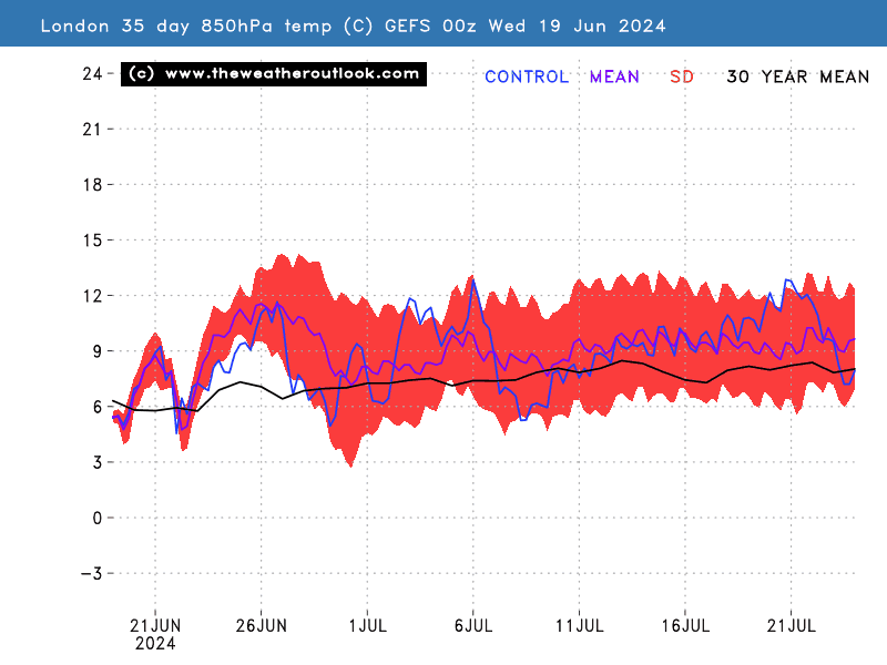
UserPostedImage


Brian Gaze

Berkhamsted

TWO Buzz - get the latest news and views 

"I'm not socialist, I know that. I don't believe in sharing my money." - Gary Numan

fairweather
15 December 2022 21:53:23

Yes, it's interesting how GFS and ECM Ops are both at the upper end of their ensemble range towards the later stages of  the 12z. Wonder if there's a technical reason for that?  Or just coincidence?

Originally Posted by: marcus72 

Well it just is. And it often is. Which is why I only bother commenting when ensembles are out because any run in isolation can often be at the extreme and the control and op run are no different from that standpint.


S.Essex, 42m ASL
Brian Gaze
15 December 2022 21:55:57
ECM ENS 12z update has shifted milder too. A significant change in the south at least. 

UserPostedImage


Brian Gaze

Berkhamsted

TWO Buzz - get the latest news and views 

"I'm not socialist, I know that. I don't believe in sharing my money." - Gary Numan

fairweather
15 December 2022 22:07:02

Have to say I disagree, there was time back in the early days when it was over the top, but now it's very level headed and considered - in fact your are more likely to see mild ramping! Personally, I now miss the over the top, cold and snow ramping posts and I wish Brian would allow new members to inject some new blood into the forum.

Originally Posted by: overland 

But if that were true that contradicts your "level headed" comment. People should only make a genuine observation from what they see in the models. If there is "ramping" in either direction then it isn't better. They don't have to be right but it shouldn't be deliberate ramping because that would be provocative.

For what it's worth I think there is consensus in the models that it will be less cold up till Boxing Day than the previous 10 days. I never look past 10 personally. Not saying much considering this spell turned out colder than any predictions I saw!


S.Essex, 42m ASL
Brian Gaze
15 December 2022 22:09:26

Have to say I disagree, there was time back in the early days when it was over the top, but now it's very level headed and considered - in fact your are more likely to see mild ramping! Personally, I now miss the over the top, cold and snow ramping posts and I wish Brian would allow new members to inject some new blood into the forum.

Originally Posted by: overland 

We've had about 50 new members in the last few weeks. Whether they post or not is a different matter.


Brian Gaze

Berkhamsted

TWO Buzz - get the latest news and views 

"I'm not socialist, I know that. I don't believe in sharing my money." - Gary Numan

johncs2016
15 December 2022 22:09:57

I'm not really sure I agree with that. When I published the TWO winter forecast on Dec 1st there was already a signal from GEFS35 for the cold to break mid-month. About 7 to 10 days ago (or thereabouts) I gave the spread for the end of this cold spell to be 12/12 to 17/12 which some people took exception to. I would say it has turned out be a reasonably accurate as have the initial projections from the GEFS35 in late November and early December.

The latest GEFS35 (remember it is 24 hours behind the latest runs regardless of where you are viewing it) doesn't hold out much hope of a colder than average January. I know we hear reports about CFS and the "pros" at X, Y or Z who are explaining the "real reasons" why cold periods are nailed on for the next month or longer. However, a lot of what gets posted is bunkum. The biggest team of pros in the UK work for the UK Met Office and they have been favouring a front loaded winter. 

UserPostedImage

Originally Posted by: Brian Gaze 

On that note, I can see this winter panning out in a similar fashion to 2010/2011 except that although this has been a very impressive cold spell by modern standards, it hasn't been as intense as what we saw in December 2010 and it also started a bit later this time (that really cold weather in 2010 actually started towards the end of the previous November before we had even entered in that meteorological winter).

That resulted in that exceptionally cold start to the winter of 2010/2011 but once we got past the really cold weather in December 2010, the rest of that winter would never be quite as cold as that and so, that was a front-loaded winter.

Moving on through that winter, January 2011 was a transitional month where there was an ongoing battle between the cold air which was trying to hang on, and the milder air which was trying to get in. That created a very messy situation which resulted in that being quite a wet month overall. If my memory serves me right, I think that there was still some snow in Scotland during January 2011, but with that being much more restricted to the hills and higher ground than was the case in the previous month.

After that, February 2011 was just a really mild month overall which at that time, had already very quickly resulted in the really cold weather from just a couple of months earlier on, being a mere distant memory.

I have a hunch that this winter could pan out in a similar fashion. However, this doesn't necessarily mean that winter will effectively be over once this latest cold spell is out of the way though. Anything can still happen after all and there has been some recent model output which has suggested that the cold weather could make a return, possibly even around or before Christmas (in any case, I would probably end up getting peltered on here if I did try to claim that winter was "over" and I certainly wouldn't want that to happen).


The north of Edinburgh, usually always missing out on snow events which occur not just within the rest of Scotland or the UK, but also within the rest of Edinburgh.

fairweather
15 December 2022 22:14:48
I'm pretty confident the GFS ensembles at least showed good agrrement from about two weeks ago that this cold spell would finish around the 17th. It may be a day or to later now. I remember because I have a specific journey to make on the 17th and I would prefer it if it wasn't affected by severe cold. 
S.Essex, 42m ASL
Joe Bloggs
15 December 2022 22:18:10
18z GFS not showing any signs of a flip back to cold sadly. 

That low really winding up where we don’t want it to. 

https://www.wetterzentrale.de/maps/GFSOPEU18_114_1.png 

At this rate we might be looking at the possibility of a named storm 😂

Karl Guille
15 December 2022 22:22:23
A better angle to the Low on the 18z bringing in colder uppers in the run up to Christmas but not sure if this will improve things for the big day itself!

https://modeles16.meteociel.fr/modeles/gfs/runs/2022121518/gfs-1-174.png?18 


St. Sampson

Guernsey

Brian Gaze
15 December 2022 22:24:46
The jet stream is also looking a lot stronger and more organised than recently.

UserPostedImage


Brian Gaze

Berkhamsted

TWO Buzz - get the latest news and views 

"I'm not socialist, I know that. I don't believe in sharing my money." - Gary Numan

Joe Bloggs
15 December 2022 22:26:03
Maybe I was a tad presumptuous.

Once the low moves through (after making a very big deal about doing so) , we do get an Arctic plunge. A horrible Iberian High though. 

Still LOTS of uncertainty and very fine margins with all that blocking up north. 

https://www.wetterzentrale.de/maps/GFSOPEU18_174_1.png 


Heavy Weather 2013
15 December 2022 22:27:42

18z GFS not showing any signs of a flip back to cold sadly. 

That low really winding up where we don’t want it to. 

https://www.wetterzentrale.de/maps/GFSOPEU18_114_1.png 

At this rate we might be looking at the possibility of a named storm 😂

Originally Posted by: Joe Bloggs 

Yes, undoubtedly a clear shift in the wrong direction this evening. That low has been a right pain in the neck. I think  my focus may shift tomorrow to next weekend, and hope we can get something at least seasonal for Christmas for some of us across the country.

Hoping the 0z pulls a rabbit out of the hat. But if we see more of the same that would be the hatrick.

Seeing that low spin up like that still feels

odd though. 


Mark

Beckton, E London

Less than 500m from the end of London City Airport runway.

Heavy Weather 2013
15 December 2022 22:31:20
Actaully Christmas Eve Northerly anyone?
Mark

Beckton, E London

Less than 500m from the end of London City Airport runway.

doctormog
15 December 2022 22:33:39
After the mild start to next week all sorts of options look like being on the table. The 18z GFS op highlights that uncertainty.
Karl Guille
15 December 2022 22:34:19
A very different looking Xmas Day on the 18z but no doubt things will continue to chop and change as the big day approaches.

https://modeles16.meteociel.fr/modeles/gfs/runs/2022121518/gfs-1-228.png?18 


St. Sampson

Guernsey

Joe Bloggs
15 December 2022 22:36:26
Lol a nice Christmas Eve blizzard for me and Saint. If only. 😂 

Night! 

David M Porter
15 December 2022 22:42:18

After the mild start to next week all sorts of options look like being on the table. The 18z GFS op highlights that uncertainty.

Originally Posted by: doctormog 

Indeed, Michael. It is still very hard indeed to have any real amount of confidence about what is likely to happen as we go into the start of the festive period at the moment with so much run-to-run variability still evident, never mind what is likely to develop as we head 2023.

Sit back and enjoy the ride the models are giving us would be my advice. 😉


Lenzie, Glasgow

"A body of men holding themselves accountable to nobody ought not to be trusted by anybody." – Thomas Paine

Remove ads from site