The Weather Outlook

Remove ads from site

Hungry Tiger
10 January 2022 14:58:21

But it'd be a milder blip, as a few days later, things evolve into this jolly little chart 


"Fantasy Weather"

Originally Posted by: Saint Snow 

Good posts there Saint. There are quite a few hints of a cold spell of sorts coming off - But I can't help thinking what happened in December when we all thought something good was going to materialise.


Gavin S. FRmetS.

TWO Moderator.

Contact the TWO team - [email protected]

South Cambridgeshire. 93 metres or 302.25 feet ASL.


tallyho_83
10 January 2022 15:56:29

One other interesting thing at the moment is the southwesterly flow looks to be cut off. Annoyingly I can't find my notes, but the analogues were strongly supporting an anticyclonic period mid Jan and then a bitterly cold first half Feb. Hence, at least in part, the seasonal I published:

https://www.theweatheroutlook.com/forecast/uk-seasonal-weather-forecast


Originally Posted by: Brian Gaze 

Great forecast based on frost and fog around middle of January and milder to the NW of the UK. Fingers crossed for a cold start to February with some snow .


Home Location - Vixen Tor Close, Okehampton, Devon (221m ASL)

---------------------------------------

Sean Moon

Magical Moon

www.magical-moon.com

ballamar
10 January 2022 16:14:36
GFS looks a little better up to 132 hopefully we can get the jet to sink south
Hippydave
10 January 2022 16:15:47

Icon looking to move the HP far enough North and West to allow a glancing blow of cold air down the east of the country - chilly before hand so could be a fairly lengthy period of suppressed temps for some areas. Not a model I pay too much attention to but, as Brian often says, ECM is frequently similar so gives some pointers on what to expect when that comes out.

Hopefully this attempt at low level cold under stagnant HP will materialise, unlike the before Xmas one which was a few dry mild days before it all collapsed.


Home: Tunbridge Wells

Work: Tonbridge

Hippydave
10 January 2022 16:31:45

Interesting GFS Op run upto T201

Relies on an initial HP build towards Greenland/Iceland to get the cold in and the Jet needs to play ball and loop up and round as shown. Doesn't look too stable a block as it's sinking off but nice to see the blues marching south anyway.


Home: Tunbridge Wells

Work: Tonbridge

Taylor1740
10 January 2022 16:43:55

Interesting GFS Op run upto T201

Relies on an initial HP build towards Greenland/Iceland to get the cold in and the Jet needs to play ball and loop up and round as shown. Doesn't look too stable a block as it's sinking off but nice to see the blues marching south anyway.

Originally Posted by: Hippydave 

Yes looks like the possibility of a potent but short-lived Northerly is there for early-mid next week.

Then I expect as we get nearer to February we should start to see more hints of a Scandi high forming, given that's the traditional time of year for Scandi highs to make an appearance.


NW Leeds - 150m amsl
Ally Pally Snowman
10 January 2022 17:04:56

GEM also looks good for a cold northerly in day 7/8 range. Decent HLB as well . Is winter finally turning up?


Bishop's Stortford 85m ASL.
Gusty
10 January 2022 17:05:21
doctormog
10 January 2022 17:13:33
Yes, there seems to be a bit of a shift towards some of the recent colder ensemble options. It will be interesting to see if there is any support or indeed if the signal is there tomorrow.
western100
10 January 2022 17:31:23

One other interesting thing at the moment is the southwesterly flow looks to be cut off. Annoyingly I can't find my notes, but the analogues were strongly supporting an anticyclonic period mid Jan and then a bitterly cold first half Feb. Hence, at least in part, the seasonal I published:

https://www.theweatheroutlook.com/forecast/uk-seasonal-weather-forecast


Originally Posted by: Brian Gaze 

The one thing you can say at the moment is there aren’t signs of any SW’ly flows

Mid-Atlantic is very blocked which stops encroachment of SW flows 


Worcestershire / Warwickshire Border

100m ASL

X…..@Weather4u2

jhall
10 January 2022 18:41:24

Yes, there seems to be a bit of a shift towards some of the recent colder ensemble options. It will be interesting to see if there is any support or indeed if the signal is there tomorrow.

Originally Posted by: doctormog 

At T+168 it looks like the ECM op run is sending the northerly plunge too far to our east to do us any good.


Cranleigh, Surrey
doctormog
10 January 2022 18:48:57


At T+168 it looks like the ECM op run is sending the northerly plunge too far to our east to do us any good.


Originally Posted by: jhall 

Yes, quite a number of options have and are currently showing that and it is quite a realistic outcome. Small changes will have big impacts one way or the other.


western100
10 January 2022 19:02:19
ECM makes it a more mobile pattern by day 10

GFS is exceptionally dry and HP dominant

Atlantic has very little influence on the UKs weather with the GFS, potentially for the whole month which would be extreme in that standalone context.


Worcestershire / Warwickshire Border

100m ASL

X…..@Weather4u2

Gusty
10 January 2022 19:33:33

ECM makes it a more mobile pattern by day 10

GFS is exceptionally dry and HP dominant

Atlantic has very little influence on the UKs weather with the GFS, potentially for the whole month which would be extreme in that standalone context.

Originally Posted by: western100 

Mobile pattern at Day 10 it is then. 


Steve - Folkestone, Kent

Current conditions from my Davis Vantage Vue

https://www.wunderground.com/dashboard/pws/IFOLKE11 

Join Kent Weather on Facebook.

https://www.facebook.com/stevewall69/ 


DPower
10 January 2022 19:39:01

ukmo, ecm, gfs, icon and gem all show more amplified runs out to day 7 or so. Some obviously more than others. I wonder what they are seeing to cause this reaction and will it continue in future runs. At least there is some interest in the model output again.

western100
10 January 2022 20:01:26

ukmo, ecm, gfs, icon and gem all show more amplified runs out to day 7 or so. Some obviously more than others. I wonder what they are seeing to cause this reaction and will it continue in future runs. At least there is some interest in the model output again.

Originally Posted by: DPower 

Low pressure is quite common on the models over Greenland and keeps flattening the HP back over the UK

At times there’s been lots of scenarios with good amplified set up but I do think any amplification won’t last due to the energy North


Worcestershire / Warwickshire Border

100m ASL

X…..@Weather4u2

Chunky Pea
10 January 2022 20:39:58

But it'd be a milder blip, as a few days later, things evolve into this jolly little chart 


"Fantasy Weather"

Originally Posted by: Saint Snow 

I can only assume you are being sarcastic here because I fail to see anything of interest in that chart. A bump up in light drizzle potential maybe, but that's about it. 


Patrick,

East Galway, Ireland.

doctormog
10 January 2022 20:51:04


I can only assume you are being sarcastic here because I fail to see anything of interest in that chart. A bump up in light drizzle potential maybe, but that's about it. 

Originally Posted by: Chunky Pea 

No, you’re just being late in your response, Saint’s comment was based on the GFS P11 from the 06z run valid at the time of writ8ng, which showed this: https://www.wetterzentrale.de/maps/GFSP11EU06_360_2.png 


Chunky Pea
10 January 2022 20:59:27


No, you’re just being late in your response, Saint’s comment was based on the GFS P11 from the 06z run valid at the time of writ8ng, which showed this: https://www.wetterzentrale.de/maps/GFSP11EU06_360_2.png 

Originally Posted by: doctormog 

Ah right! Thanks. That is a nice chart alright. Might actually get a frost and some snow from that.

Frost count this winter so far: 1 


Patrick,

East Galway, Ireland.

Saint Snow
10 January 2022 21:09:36


No, you’re just being late in your response, Saint’s comment was based on the GFS P11 from the 06z run valid at the time of writ8ng, which showed this: https://www.wetterzentrale.de/maps/GFSP11EU06_360_2.png 

Originally Posted by: doctormog 


Thanks, Michael - the perils of posting charts 


Martin

Home: St Helens (26m asl) Work: Manchester (75m asl)

A TWO addict since 14/12/01

"How can wealth persuade poverty to use its political freedom to keep wealth in power? Here lies the whole art of Conservative politics."

Aneurin Bevan

tallyho_83
10 January 2022 22:43:25

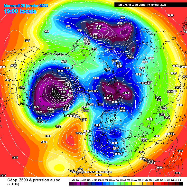
Anyone agree that this is a perfect set up for a northerly @ +150z on the 18z GFS OP run with HP of 1065/1070mb blocking over Greenland and see how quickly it goes pear shaped?


Home Location - Vixen Tor Close, Okehampton, Devon (221m ASL)

---------------------------------------

Sean Moon

Magical Moon

www.magical-moon.com

Gandalf The White
10 January 2022 23:26:44

Anyone agree that this is a perfect set up for a northerly @ +150z on the 18z GFS OP run with HP of 1065/1070mb blocking over Greenland and see how quickly it goes pear shaped?

Originally Posted by: tallyho_83 

No, because the atmosphere is represented by a movie, not a still photograph; what you have here is a still which doesn’t show how we got to that frame. The other problem is that the high pressure is about 500-1,000 miles too Far East.

The set up right at the end of the run is much better - but of course it’s over 2 weeks away…. Again.

Location: South Cambridgeshire

130 metres ASL

52.0N 0.1E


tallyho_83
10 January 2022 23:46:36


No, because the atmosphere is represented by a movie, not a still photograph; what you have here is a still which doesn’t show how we got to that frame. The other problem is that the high pressure is about 500-1,000 miles too Far East.

The set up right at the end of the run is much better - but of course it’s over 2 weeks away…. Again.

Originally Posted by: Gandalf The White 

Yes what we want to see is retrogression not topplers.


Home Location - Vixen Tor Close, Okehampton, Devon (221m ASL)

---------------------------------------

Sean Moon

Magical Moon

www.magical-moon.com

Gandalf The White
10 January 2022 23:55:03


Yes what we want to see is retrogression not topplers.

Originally Posted by: tallyho_83 


Yes, but topplers are merely a symptom of the underlying problem - too much energy in the northern arm of the jet.

The ensemble suite is rolling out and up to T+192 there are 5-6 options where the high eases sufficiently westwards to bring the Arctic airstream down across the country.  Against that there are several that put the high to our east or south-east - the rest have it more or less overhead.


Location: South Cambridgeshire

130 metres ASL

52.0N 0.1E


BJBlake
11 January 2022 06:45:37


Yes, but topplers are merely a symptom of the underlying problem - too much energy in the northern arm of the jet.

The ensemble suite is rolling out and up to T+192 there are 5-6 options where the high eases sufficiently westwards to bring the Arctic airstream down across the country.  Against that there are several that put the high to our east or south-east - the rest have it more or less overhead.


Originally Posted by: Gandalf The White 

That’s a useful Summary Peter, so 20% chance of meaningful cold - 80% meh: The average being a rather cold - cloudy and Atlantic influenced north-westerly flow. Not much good for anyone - I.e not windy enough for wind power, not proper cold, not sunny, not replenishing the aquifers, nor frosty. Hmm - the definition of anti cyclonic gloom.

I’ll keep my fingers and eyes crossed for the 20% outcome...


Brecklands, South Norfolk 28m ASL

Remove ads from site