Remove ads from site
Onwards............
TWO Moderator
Today's summary posted by DEW in previous thread......
GFS; HP over UK continues to fend off LP to west, north and east until Wed 20th when it moves to Greenland and lets in ne-lies from LP over Scandi (that LP stretches back well across Russia so a long fetch of cold air). There is then a battle between HP on Atlantic and LP over Scandi, with the HP winning rather unconvincingly by Wed 27th and looking likely to be squeezed out S-wards
GEFS; after a mild-ish and slightly damp few days this week, temp settle down to about 3C below norm and dry (well, dry-ish) with moderately good agreement to Fri 22nd. Then hell breaks loose with op 15C below norm and control 10C above - not much pptn but such runs as show it go overboard with very large amounts. Fewer runs on the mild side in Scotland and the N of England
ECM; similar to GFS but more of a N-ly than NE-ly later on (early morning i.e. before 0630 comments on ECM must refer to yesterday's 12z because the 0z is, as they say, back on track)
Model alignment for 240 hours - here comes the Arctic Ice Bear - and look at the snowy Para - with those 1947 lows bringing true blizzards.... Just need it to reach real time....because the CNTRL is still a concern, trying to cage the ice bear.
Also in previous thread from Darren
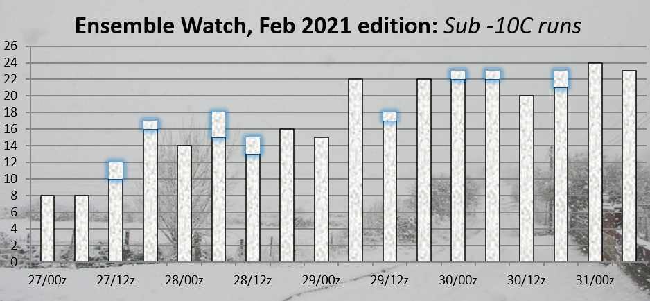
Here's the latest "ensemble watch", up to 18z last night.
The ECM ensembles, on the other hand, are much less keen on -10 being reached, much less -15!
Originally Posted by: llamedos
In truth about 40% of the GFS perturbations are also far from cold, but at least most are. It’s still all to play for, but I do remember the same game in 2018 right up to 1 week away. Past performance is not a guarantee of future performance of course...as the saying goes.
Originally Posted by: BJBlake
I think the BFTE in 2018 was solidly agreed on from T192 by the models that went that far, possibly even just over 200 hours. This is fraught with mid-term hurdles.
Decent enough
Marcus
Banbury
North Oxfordshire
378 feet A S L
I also like it when Monday 0z runs start of on a good note.
There is another period off SSW warming due as well which I understand could finish the PV off totally.
The next few runs are crucial, I want to see a solidifying of the position and even upgrades. I love a cheeky upgrade.
Beckton, E London
Less than 500m from the end of London City Airport runway.
GFS 240 h
ECM 240 h
We are slowly getting there
Originally Posted by: Shropshire
That's what I recall. From a week away at least we could see what was coming and nobody could really claim that it took them by surprise. There were of course one or two 'wobbles' along the way but that is to be expected. Indeed it would be surprising if there weren't. But the main trend for cold was always there.
Bolton, Lancashire
160m asl
Snow videos:
http://www.youtube.com/channel/UC3QvmL4UWBmHFMKWiwYm_gg
Originally Posted by: Gooner
Hopfully those mild runs on the 17th will be dropped soon. It does to my untrained eye look like the 15th is now the marker, I am sure that this has move forwards. We were looking at the 18th I think at the start of the weekend
Para 240 h
Catching up with the OP
The Control say's NO
ECM has 25cm widely for southern England with this.
https://www.wetterzentrale.de/en/topkarten.php?map=20&model=ecm&var=2&run=0&time=240&lid=OP&h=0&mv=0&tr=24#mapref
Para has some unbelievable cold nights late on. -19c Herefordshire.
https://www.wetterzentrale.de/en/topkarten.php?map=20&model=gfs&var=17&run=0&time=339&lid=PARA&h=0&mv=0&tr=1#mapref
Originally Posted by: Ally Pally Snowman
And the North Sea begining to freeze over too :)
NW Leeds
187m asl
My PWS
Originally Posted by: Col
Be skating across to the Low Countries before we know it
So most go colder from day 8 whereas as we can see it takes the OP until day 9, but there are a number of milder members and that's not surprising given the matters to be resolved.
GEM @ 204
GEM @ 240
Around -14 to -16C around Birmingham and having a good snow cover hope we see clear skies this time so I can able to record very low snow surface temps and 2m air temps for once after many times miss out from previous cold spells that often cloudy and mild nights.
Whilst the operationals look very good this morning, the ensembles show the massive amount of uncertainty and spread. Therefore confidence in any of these solutions is very low. Still a very long way to go to get a memorable cold spell. From this point forward if we measure everything against this mornings operationals, there is bound to be disappointment.
Originally Posted by: Tim A
Agreed. When you look at this chart, a few days before all hell breaks loose on the GFS 00z op:
https://www.wetterzentrale.de/en/topkarten.php?map=1&model=gfs&var=1&run=0&time=168&lid=OP&h=0&mv=0&tr=3#mapref
there is so much which can go wrong. A little more strength in the Atlantic lows or a shortwave here or there and it's a game changer.
The good thing is that there is pretty much cross model agreement this morning on the medium term evolution, which is encouraging.
Much better operational runs this morning, we have along way to go to get these inside the 6/7 day mark and the GFS and ECM ensembles, whilst improving need to get over some more hurdles as others have indicated. Still a very good trend and fun to watch with the ensemble watch looking good.The ECM has been flipping around more on this so that ensemble is the one to watch and tonight’s runs and longer term ensembles and PV winds will be high on my watch out list.
Martin
Greasby, Wirral.
Caution is my watchword and I wont be getting excited about any chart until there is reasonable cross model agreement at 120 ahead of the onset of any deep cold IMBY. On the basis that the onset date could be 21 January, Im thinking that 16th January Saturday is a key date. Only about 20 GFS runs til then.