The Weather Outlook

Remove ads from site

Rob K
22 December 2020 12:20:57
https://www.meteociel.fr/modeles/gfse_cartes.php?&ech=360&mode=0&runpara=1 


Yateley, NE Hampshire, 73m asl

"But who wants to be foretold the weather? It is bad enough when it comes, without our having the misery of knowing about it beforehand." — Jerome K. Jerome

Gandalf The White
22 December 2020 12:29:39

Since that's 9 days away it's JFF.

Originally Posted by: briggsy6 

Arguably some charts just 9 hours out are 'JFF'


Location: South Cambridgeshire

130 metres ASL

52.0N 0.1E


Rob K
22 December 2020 12:38:32
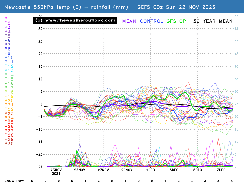
6Z GEFS has a very slight uptick in the mean with a few more milder outcomes (including the op) but still a very solid cluster of cold runs right to the end. Snow row is up to 39% on the Meteociel version for London on Xmas Eve, or 19/33 on TWO count.

https://www.theweatheroutlook.com/charts/gefs/gefsens850london0.png 


Yateley, NE Hampshire, 73m asl

"But who wants to be foretold the weather? It is bad enough when it comes, without our having the misery of knowing about it beforehand." — Jerome K. Jerome

Gandalf The White
22 December 2020 13:11:59

Not sure if anyone has commented on this yet but a fall of 60 mb in SLP in 48 hours is quite rare in the south, I believe.  It won't just be the forecasters having a few headaches.....


Location: South Cambridgeshire

130 metres ASL

52.0N 0.1E


Quantum
22 December 2020 13:16:49

I'd describe the weather over the next few weeks as quite icelandic.

Not overly cold, very LP dominated, jet stream well to the south and completely within the polar airmass. 


25/26 (850hpa temp) 11 days snow/sleet falling

18/11 (-4) 19/11 (-6) 20/11 (-6) 01/01 (-7) 04/01 (-10) 10/01 (-7) 11/01 (-3) 30/01 (-1) 13/02 (-6) 15/02 (-4) 18/02 (-6)

24/25 10d

18/11 (-6) 19/11 (-6) 23/11 (-2) 22/12 (-5) 04/01 (-5) 05/01 (0)14/02 (0) 15/02 (0)12/03 (-6) 13/03 (-6)

23/24 8d

29/11 (-6) 30/11 (-6) 02/12 (-5) 03/12 (-5) 04/12 (-3) 16/01 (-3) 18/01 (-8)08/02 (-5)

22/23 7d

18/12 (-1)06/03 (-6) 08/03 (-8) 09/03 (-6) 10/03 (-8) 11/03 (-5) 14/03 (-6)

21/22 12d

Gandalf The White
22 December 2020 13:21:03

6Z GEFS has a very slight uptick in the mean with a few more milder outcomes (including the op) but still a very solid cluster of cold runs right to the end. Snow row is up to 39% on the Meteociel version for London on Xmas Eve, or 19/33 on TWO count.

https://www.theweatheroutlook.com/charts/gefs/gefsens850london0.png

Originally Posted by: Rob K 


Yes, those 3-4 ensemble options plus the Op all rising by several degrees is sufficient to push the mean up a little.  As you say, the majority still stay solidly cold.

But as your post highlighting the evolution of the parallel run shows, there are a lot of routes to continuing cold still on the table as well as a few paths back to something less cold or milder. 

When the atmosphere is behaving in an unusually turbulent manner it makes the longer range outcomes even more problematic.


Location: South Cambridgeshire

130 metres ASL

52.0N 0.1E


Hungry Tiger
22 December 2020 14:30:42

I'd describe the weather over the next few weeks as quite icelandic.

Not overly cold, very LP dominated, jet stream well to the south and completely within the polar airmass. 

Originally Posted by: Quantum 

Best month for that was January 1984.


Gavin S. FRmetS.

TWO Moderator.

Contact the TWO team - [email protected]

South Cambridgeshire. 93 metres or 302.25 feet ASL.


doctormog
22 December 2020 14:40:56

Not sure if anyone has commented on this yet but a fall of 60 mb in SLP in 48 hours is quite rare in the south, I believe.  It won't just be the forecasters having a few headaches.....


Originally Posted by: Gandalf The White 

That’s impressive!


Saint Snow
22 December 2020 14:50:22

First chance to look at the 6z ENS (hadn't had chance to review since yesterday's 12z), and am surprised and disappointed to see that for this area (and some of the others I've looked at), the mean and the Op are both sitting a couple degrees milder for that period commencing 27th Dec, putting us the wrong side of the -5c 850 line. The result is that that snow that was forecast on Sunday on yesterday's charts is now showing as rain.
Bit of a stinker, but f***ing typical of this crap country

.

And Boxing Day is going to be an atrocious washout for the majority of the UK away from the SE:


Martin

Home: St Helens (26m asl) Work: Manchester (75m asl)

A TWO addict since 14/12/01

"How can wealth persuade poverty to use its political freedom to keep wealth in power? Here lies the whole art of Conservative politics."

Aneurin Bevan

Phil24
22 December 2020 16:01:37

[quote=Retron;1289099]

A massive change in the ECM strat forecasts... an SSW is now within spitting distance, having been unlikely before.

https://apps.ecmwf.int/webapps/opencharts/products/extended-zonal-mean-zonal-wind?area=nh&base_time=202012210000

(Use the "time" dropdown, top left, to see previous forecasts).

Usually these things correct up, not down, so it makes a pleasant change to see it. If nothing else, that should mean more unusual synoptics to come...

If it materialises, expect some interesting weather around the third week of Jan.  flipping typical, I’m off to Dubai for three weeks. 

Rob K
22 December 2020 16:24:09
Some subtle changes on the 12z GFS with a more easterly influence and consequently rather snowier in the south. Nothing modelled to settle though.

https://modeles.meteociel.fr/modeles/gfs/runs/2020122212/gfseuw-2-162.png?12 


Yateley, NE Hampshire, 73m asl

"But who wants to be foretold the weather? It is bad enough when it comes, without our having the misery of knowing about it beforehand." — Jerome K. Jerome

Ally Pally Snowman
22 December 2020 16:28:26

Looks like a better GFS 12z lots of marginal fun. Decent GH setting up could be a good start to the new year.


Bishop's Stortford 85m ASL.
ballamar
22 December 2020 16:30:18

Some subtle changes on the 12z GFS with a more easterly influence and consequently rather snowier in the south. Nothing modelled to settle though.

https://modeles.meteociel.fr/modeles/gfs/runs/2020122212/gfseuw-2-162.png?12

Originally Posted by: Rob K 

Hopefully all feeds in to cool things down, creating our own cold pool. Before the real cold uppers are upon us 

ballamar
22 December 2020 16:35:16
Impressive pattern on GFS 1060 GH with some additional warming and a sinking low
idj20
22 December 2020 16:48:18

First chance to look at the 6z ENS (hadn't had chance to review since yesterday's 12z), and am surprised and disappointed to see that for this area (and some of the others I've looked at), the mean and the Op are both sitting a couple degrees milder for that period commencing 27th Dec, putting us the wrong side of the -5c 850 line. The result is that that snow that was forecast on Sunday on yesterday's charts is now showing as rain.

Bit of a stinker, but f***ing typical of this crap country

.

And Boxing Day is going to be an atrocious washout for the majority of the UK away from the SE:

Originally Posted by: Saint Snow 


Indeed, the weekend looks absolutely dreadful for South Kent. I really can't get excited about "punching" through nearly a solid day of strong southerly gales and heavy rain just to experience sloppy seconds cool and damp weather afterwards.


All that pain for basically little gain, I'm done with this "winter" (more like an extension of Autumn) and just want Spring-type weather to start ASAP.


Home location: Folkestone Harbour.
jhall
22 December 2020 16:55:34

Not sure if anyone has commented on this yet but a fall of 60 mb in SLP in 48 hours is quite rare in the south, I believe.  It won't just be the forecasters having a few headaches.....


Originally Posted by: Gandalf The White 

Something to bear in mind when considering 850mb temps. 850mb would be a lot closer to the surface after that fall of pressure than it was before it.


Cranleigh, Surrey
NDunwell
22 December 2020 16:56:42


All that pain for basically little gain, I'm done with this winter and just want Spring-type weather to start ASAP.

Originally Posted by: idj20 


Wow... done with winter after 1 day!?


Nick

Ruislip (2 miles from the Northolt recording station)

idj20
22 December 2020 16:59:19


Wow... done with winter after 1 day!?

Originally Posted by: NDunwell 


Yup, as it is looking like becoming yet another extension of Autumn, as least as far as my neck of the woods is concerned.


Home location: Folkestone Harbour.
Brian Gaze
22 December 2020 16:59:19

Interesting.


Brian Gaze

Berkhamsted

TWO Buzz - get the latest news and views 

"I'm not socialist, I know that. I don't believe in sharing my money." - Gary Numan

Shropshire
22 December 2020 17:00:16

The GFS and GEM both take the initial trough South straight through the UK whereas the UKMO wouldn't if it went further than day 6 and obviously that impacts on what happens later so let's see what the ECM does later on.


From December 27th 2020, zonality will be banned from mixing with the UK. We appreciate that this may come as a shock to younger people and old Uncle Barty. This ban will last for a minimum of ten days.
NDunwell
22 December 2020 17:06:32


Yup, as it is looking like becoming yet another extension of Autumn, as least as far as my neck of the woods is concerned.

Originally Posted by: idj20 


An even wierder take then, considering the current synoptic set up is about as removed as you can get from autumn. In fact i'd say the current synoptic set up is one of real interest for any weather enthusiast as there is no telling how this will work out. There is potential to deliver quite a special January or it could be just cool and wet but i see little evidence of anything zonal for quite some time.


Nick

Ruislip (2 miles from the Northolt recording station)

SJV
22 December 2020 17:12:13


An even wierder take then, considering the current synoptic set up is about as removed as you can get from autumn. In fact i'd say the current synoptic set up is one of real interest for any weather enthusiast as there is no telling how this will work out. There is potential to deliver quite a special January or it could be just cool and wet but i see little evidence of anything zonal for quite some time.

Originally Posted by: NDunwell 

I think what Ian is getting at is conditions at the surface. Kent is unfortunate in this respect as, even with the current synoptic set up you allude to, conditions will very likely be wet there rather than white.

If it was 8C and raining in this set up, how much of a difference are you really going to feel from a zonal 11C and rain? It doesn't matter how unusual the synoptics are if they don't translate to anything special at the surface 

That being said, I live close to the Peak District so I am full expecting some snow over the next few weeks from this set up (sorry, Ian! )

some faraway beach
22 December 2020 17:14:23


Something to bear in mind when considering 850mb temps. 850mb would be a lot closer to the surface after that fall of pressure than it was before it.

Originally Posted by: jhall 

I'd never thought about it that way before. I mean, I understand the arithmetic for calculating thicknesses and all that, but it had never occurred to me just why the 528 decametre line works the way it does to predict snow.

I feel a bit thick myself now.


2 miles west of Taunton, 32 m asl, where "milder air moving in from the west" becomes SNOWMAGEDDON.

Well, two or three times a decade it does, anyway.

idj20
22 December 2020 17:20:10


An even wierder take then, considering the current synoptic set up is about as removed as you can get from autumn. In fact i'd say the current synoptic set up is one of real interest for any weather enthusiast as there is no telling how this will work out. There is potential to deliver quite a special January or it could be just cool and wet but i see little evidence of anything zonal for quite some time.

Originally Posted by: NDunwell 


The highlighted text of your sentence must explain the 11.5 c, rain and hill mist I'm currently experiencing here at my end of Kent. At least winds are dead calm for now, though.

But as always, as far as the mid-range outputs are concerned it still feels like chasing rainbows. Or perhaps being born in the late 1960s, I'm still blinded by distant memories of early Winter snowy spells in the early 1970s and '80s. Even the Great Cold Snap of Dec '10 came to a crashing end just before Christmas and the rest of that winter turned out quite dry and totally snow-free.  Although to be fair, I did well in terms of low level and settling snowfalls in Winters 2012 and 2013 but even those weren't particularly long lasting cold snaps. March 2013 was the last time I got to see an actual snow cover (yes, I missed out on the so-called Beast From The East in the tail end of Winter 2018).


Home location: Folkestone Harbour.
White Meadows
22 December 2020 17:28:36

Cripes, is this the moaning thread or the trip down memory lane thread? Or both?
12z ensembles look just as good to me, slightly slower getting to -5 after the Boxing Day/ 27th flood but sustained thereafter... and more often than not we are scrambling around looking for marginal events over a 24 hour period. I may be mistaken but where we currently stand there’s plenty of room for upgrades given the predicted longevity of the set up unfolding.

Remove ads from site