The Weather Outlook

Remove ads from site

Rob K
20 December 2020 21:51:40
Today's GFS parallel run is interesting. It doesn't go for the big Greenland high and northerly but still ends up with a Scandi high and a pretty decent easterly:

https://www.meteociel.fr/modeles/gfse_cartes.php?&ech=324&mode=0&runpara=1 


Yateley, NE Hampshire, 73m asl

"But who wants to be foretold the weather? It is bad enough when it comes, without our having the misery of knowing about it beforehand." — Jerome K. Jerome

Rob K
20 December 2020 22:25:27
18Z has the high somewhat further east although not as strong. Could work in our favour, or not.
Yateley, NE Hampshire, 73m asl

"But who wants to be foretold the weather? It is bad enough when it comes, without our having the misery of knowing about it beforehand." — Jerome K. Jerome

Brian Gaze
20 December 2020 22:30:10

More of the same on the 18z. Continues to look marginal rain or snow in much of the country to me. Most of the time a greater risk of snow in the north and over high ground.


Brian Gaze

Berkhamsted

TWO Buzz - get the latest news and views 

"I'm not socialist, I know that. I don't believe in sharing my money." - Gary Numan

Gooner
20 December 2020 22:43:01

A cold end to the year 


Remember anything after T120 is really Just For Fun


Marcus

Banbury

North Oxfordshire

378 feet A S L


Russwirral
20 December 2020 22:44:57
Arpege puts down qlot of snow to snowdonia by wed night
Tim A
20 December 2020 22:45:57
Marginal is certainly the word. I know some are keen for everything to be further east with a stronger northerly or easterly flow (GFS 18z is more so compared to the 12z) but with the lack of cold uppers any wind off the North Sea will not cut it. Might be better off sat under the stagnant low and take our chances with lower thicknesses and slack winds.


Tim

NW Leeds

187m asl

 My PWS 

Gooner
20 December 2020 22:51:23

A good 18z for sure 

Cold from the NE approaching 


Remember anything after T120 is really Just For Fun


Marcus

Banbury

North Oxfordshire

378 feet A S L


Rob K
20 December 2020 22:58:55

More of the same on the 18z. Continues to look marginal rain or snow in much of the country to me. Most of the time a greater risk of snow in the north and over high ground.

Originally Posted by: Brian Gaze 

Becoming less marginal later in the run though. 
Not too dissimilar to the parallel run I posted earlier with a quicker transition to an easterly. 


Yateley, NE Hampshire, 73m asl

"But who wants to be foretold the weather? It is bad enough when it comes, without our having the misery of knowing about it beforehand." — Jerome K. Jerome

Karl Guille
20 December 2020 23:27:41
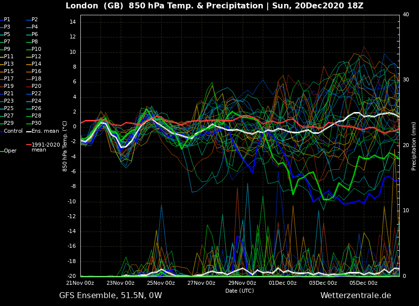
Short ensembles for London looking colder too on the GFS 18z!

https://modeles16.meteociel.fr/modeles/gensp/runs/2020122018/graphe3_00000_307.94000244140625_137.4199981689453___.gif 


St. Sampson

Guernsey

Arbroath 1320
21 December 2020 00:13:19
There are some cracking 18z ENS in the suite. Most give a prolonged cold spell, there are some less cold runs and a few offer Scandi High options.


Kenmore, Highland Perthshire, GGTTH
Gandalf The White
21 December 2020 00:21:41

There are some cracking 18z ENS in the suite. Most give a prolonged cold spell, there are some less cold runs and a few offer Scandi High options.

Originally Posted by: Arbroath 1320 

The 12z ECM ensemble mean for London T2m has shifted colder, to my surprise. Xmas Day looks very cold at 3c 

Also worth looking at the precipitation chart : the op predicts 80mm of rain (or snow) before New Year, although very much an outlier.


Location: South Cambridgeshire

130 metres ASL

52.0N 0.1E


tallyho_83
21 December 2020 00:28:03

This is an impressively cold 18z  ENS.

To see the mean not get above 0c is something isn't it!? The mean is around -5c right until the end of the run with only a few runs going above 0c but even then this doesn't happen until the end of the run anyway? Still too early to take things literally but still..!?

What would you say? cold spell developing!? SSW taking place? WHo knows!?

Home Location - Vixen Tor Close, Okehampton, Devon (221m ASL)

---------------------------------------

Sean Moon

Magical Moon

www.magical-moon.com

fairweather
21 December 2020 01:22:06

This is an impressively cold 18z  ENS.

To see the mean not get above 0c is something isn't it!? The mean is around -5c right until the end of the run with only a few runs going above 0c but even then this doesn't happen until the end of the run anyway? Still too early to take things literally but still..!?

What would you say? cold spell developing!? SSW taking place? WHo knows!?

Originally Posted by: tallyho_83 

I agree, it's a pretty good run and the snow rows add up to over a hundred now so as we say some good trends. Still doesn't look cold enough for southern lowland snow to me but it wouldn't take much. Not sure about the nothing above 0C though as the long term mean is -2C at this stage anyway.


S.Essex, 42m ASL
CField
21 December 2020 06:30:20

The impressive  low circulation  over  S Europe should be good news for NW Europe for dragging cold down, but alas  it is throwing up WAA on its eastern flank which is in turn is strangling the feed of very cold air where it is needed the most.In such a negative year which are getting fewer and fewer inbetween mildfest years , it's a crying shame really but big potential for lots of marginal wet snow events.Lucky Japan.


Favourite snowstorm

Famous channel low

Dec 31st 1978

Hastings East Sussex

Foot of level snow severe drifting

Next day max temp -4 degrees Celsius

Ally Pally Snowman
21 December 2020 06:50:17

ECM  must be very close to snowmegeddon on day 9.


Bishop's Stortford 85m ASL.
ballamar
21 December 2020 06:51:21
I can see a lot of cold rain / wet snow for southern parts. Definitely better further north. Forecasters nightmare
Gooner
21 December 2020 06:52:43

Chart image

Decent 


Remember anything after T120 is really Just For Fun


Marcus

Banbury

North Oxfordshire

378 feet A S L


moomin75
21 December 2020 06:55:28

Chart image

Decent 

Originally Posted by: Gooner 

Not bad eh?


Witney, Oxfordshire

100m ASL

White Meadows
21 December 2020 06:55:31
00z another upgrade on the first Christmas drop in 850’s then the flattening out at -5 after that short mild blip as the low sweeps over us.

However some members creep above the average this time especially later on to widen the scatter so perhaps less confidence/ more instability.

The Op is within a small cold cluster at the end.

Gooner
21 December 2020 06:56:05

Even at 384 the cold is still there 


Remember anything after T120 is really Just For Fun


Marcus

Banbury

North Oxfordshire

378 feet A S L


Whether Idle
21 December 2020 06:57:04

I can see a lot of cold rain / wet snow for southern parts. Definitely better further north. Forecasters nightmare

Originally Posted by: ballamar 

Apart from some possible flurries widely on Christmas Eve, this scenario is definitely a cold rain lovers' dream.

Higher Altiude and latitude will serve folks well if they crave snow.  I can see this being a bonanza snowy week between Christmas and the New year for the Lakeland Fells, NYMoors, Scotland with height and Snowdonia, not forgetting the Pennines.


Dover, 5m asl. Half a mile from the south coast.
Ally Pally Snowman
21 December 2020 07:03:02

ECM  does indeed have a snow event day 9 Wales and west country .


Bishop's Stortford 85m ASL.
White Meadows
21 December 2020 07:06:21
Narrative in the met o extended forecast this morning has emphasis on cold lasting for the foreseeable (mid Jan) with only short milder interludes albeit less likely than thought previously.

Upgrade ahoy- will this be reflected in some Christmas eye candy charts?..

DEW
  • DEW
  • Advanced Member
21 December 2020 07:06:27

http://www.wxmaps.org/pix/temp4 colder and drier for week 2 but not as marked as GEFS runs. Focus of rain/snow moves to N Sea suggesting a 'battleground' scenario between Continent and Atlantic

GFS - looking familiar with trough of Lp established briefly over Norway Wed 23rd, now with addition of small but quite deep secondary over Cornwall Thu 24th (first shown on ECM, hew to GFS), very marginal conditions for snowfall before the whole lot is displaced by mid-Atlantic HP Sat 26th. That doesn't last and N-S trough of LP in place by Mon 30th, centre 985mb N Sea and N-ly gales for most. That hangs around, filling and rejuvenating by turns until Wed 6th when the ridge of HP W of Ireland begins to move in. A long spell of moderately cold N-lies

GEFS - as posted by several people and quite consistent - bug drop in temp Fri 25th recovering and flat-lining with unusually good agreement (more variable in N) 3-4C below seasonal norm to Wed 6th and fairly dry after 25th

ECM - similar to GFS but LP on 30th centred a little further S and filling more quickly by the following day


I can calculate the movements of stars, but not the madness of men - Isaac Newton

Chichester 12m asl

Gooner
21 December 2020 07:07:32

That's a battering 

What does it mean for the UK , who knows , time will tell 


Remember anything after T120 is really Just For Fun


Marcus

Banbury

North Oxfordshire

378 feet A S L


Remove ads from site