The Weather Outlook

Remove ads from site

Gavin D
09 February 2019 19:19:08
Subject to no further shut-downs across the pond the delayed GFS upgrade will take place on March 20th
Hungry Tiger
09 February 2019 20:18:16

Lovely spell of weather coming up for those of us that hate winter and cannot wait to see the back of it. Days are noticeable brighter and longer now. Love it. 

Meanwhile, imagine my shock that an ensemble suite had scatter.....

Originally Posted by: Matty H 


Gavin S. FRmetS.

TWO Moderator.

Contact the TWO team - [email protected]

South Cambridgeshire. 93 metres or 302.25 feet ASL.


Hungry Tiger
09 February 2019 20:20:46

March 2013 was exceptional here. To have a run of maximum temperatures of -1, -1c, 0c, 0c, 1c, 1c after 21st March was amazing . Accompanied by heavy snow and drifting with snow on the ground past Easter. Snow had no problem settling in the middle of the day. Proof that the hunt for cold should keep going well into March.

Originally Posted by: Tim A 

That was quite amazing that was. I didn't think a maximum below 0C was possible so late in the season.


Gavin S. FRmetS.

TWO Moderator.

Contact the TWO team - [email protected]

South Cambridgeshire. 93 metres or 302.25 feet ASL.


DPower
09 February 2019 22:10:05

March 2013 was exceptional here. To have a run of maximum temperatures of -1, -1c, 0c, 0c, 1c, 1c after 21st March was amazing . Accompanied by heavy snow and drifting with snow on the ground past Easter. Snow had no problem settling in the middle of the day. Proof that the hunt for cold should keep going well into March.

Originally Posted by: Tim A 

Never seen such low maximum so late in March before. Here in hertfordshire the 22nd and 23rd I think it was we saw two ice days. Admittedly they were both cloudy days the 22nd having light snow at times through the day. The temperature in the morning was 0c but fell during day to -1c.


tallyho_83
09 February 2019 23:25:30

This is like early April only northern Scandinavia getting below freezing throughout whole of Europe by t+213!? - I really hope we get these set ups in summer!?

With winds coming up from north Africa - anticipate a risk of avalanches in Alps.


In terms of snow cover - Ireland & Scotland wouldn't do too badly in comparison to many other parts of Europe if this came about!

I mean for February this is looking virtually snow-free for many parts of Europe! wow!  early end to the ski season in Andorra and Alps! Mind you the Alps, esp Austria have had their fair share of the white stuff this winter anyway!!

http://www.wetterzentrale.de/maps/GFSOPEU18_216_47.png


Home Location - Vixen Tor Close, Okehampton, Devon (221m ASL)


Sean Moon

Magical Moon

www.magical-moon.com

tallyho_83
09 February 2019 23:40:36

Lovely spell of weather coming up for those of us that hate winter and cannot wait to see the back of it. Days are noticeable brighter and longer now. Love it. 

Meanwhile, imagine my shock that an ensemble suite had scatter.....

Originally Posted by: Matty H 

HI Matty - I think your inbox is full?

How did Yate do for snow or where you are? I heard from friends in Keynsham - they got 10cms of snow but Bristol got 20cms however, nothing compared to beast from the east last year part 1 & 2 and then on 18th March when over 25cms fell on 18th March and 30cms in parts of north Bristol. Just keen to know how you did last week? 

I anticipate not as much snow as last march but still got a good 20cms where you are? in terms of snow depth?


Home Location - Vixen Tor Close, Okehampton, Devon (221m ASL)


Sean Moon

Magical Moon

www.magical-moon.com

tallyho_83
09 February 2019 23:45:07

There are always a few ensembles that go to or below -10c @ 850hpa in the FI time frame but there is still so much scatter:

As long as we continue to see some ensembles go do to or below -10c @ 850hpa it does at least give us some hope in hell! We are still in February and i will not give up looking for cold and snow until March (spring). If there are more flips to mild then i really think it's time to say a Auf Wierdershen to winter 2018/19 and it looks like it really could be an early start to spring esp this coming weekend anyway!


Home Location - Vixen Tor Close, Okehampton, Devon (221m ASL)


Sean Moon

Magical Moon

www.magical-moon.com

tallyho_83
10 February 2019 02:12:27

Silence speaks volumes! It's crazy to think that we are in the 2nd week of February now and this is the model output forum yet the last (only comment posted) was at 22:10 and this comment wasn't anything to do with tonight's 18z model output runs. - Just says it all really i.e - how uninspiring the models are tbh! I think a lot of model watching fatigue is not starting to kick in to many members including me! Most if not all of us have seen snow but we haven't really locked into any HLB blocking and there is still no sign of this given the SSW & split PV which caused the reversal of the zonal winds - now 5 or so weeks ago!

I remember typing something similar start of January and someone said to me to be patient you have the whole month of January yet and Feb etc and by that time we would have seen a tropospheric response with HLB around Iceland/Scandi or Greenland etc but now it's the 10th of February for heavens sake. Even winter 2016/2017 we had an easterly around 11th February which brought snow flurries to the south west Saturday morning of 11th Feb 2017 and lasted for 4 hours here in Exeter. Nothing settled it was just flakes of snow and then light snow on and off all morning until the snow became more sleety and followed by ice pellets in the afternoon time!

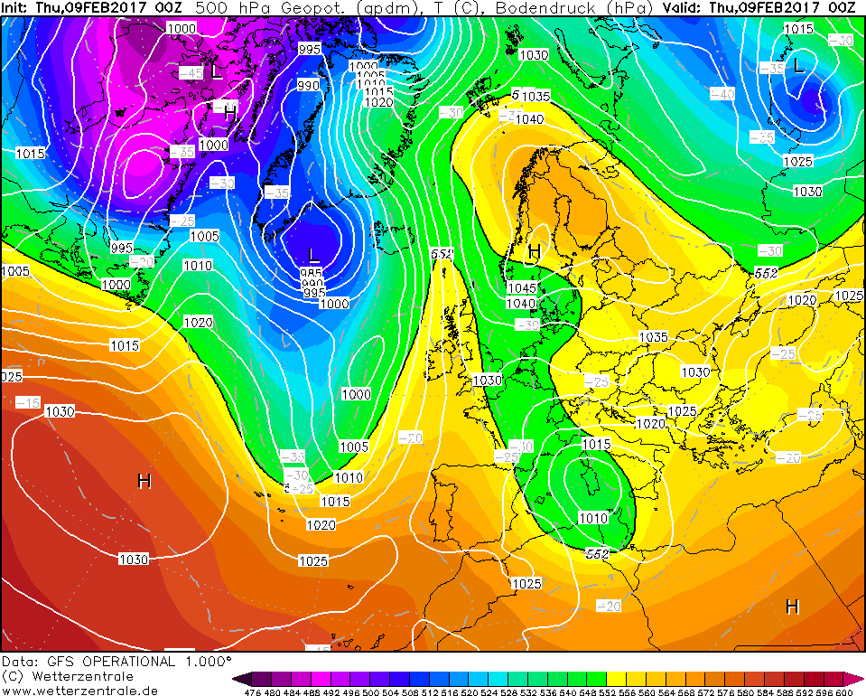
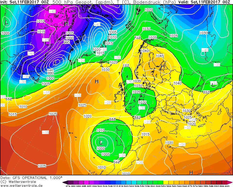
Back in February 2017 we never have a major SSW, let alone a split in the PV and reversal of zonal winds at 10hpa and 30hpa like this 2018/19 winter and back then we were in a westerly QBO - whilst that easterly back then didn't provide a major cold and snowy spell it still did occur without the help of a SSW/split vortex and zonal winds reversal at 10 and 30hpa and it was noticeable too (snow being one of them!) as you will see in the charts below. This was two years ago this weekend.(NOW!) Anyone remember this in the south?

Anyway, seeing as there is no snow, cold, HLB or easterly to discuss within the next 10 days i thought i would leave you with some below  charts which brought us an easterly two years ago today for 3-4 days between 8th and 12th February 2017:

Commencing on Wednesday night into Thursday we already see the -10c isotherm @ 850hpa approach eastern half of the country: 


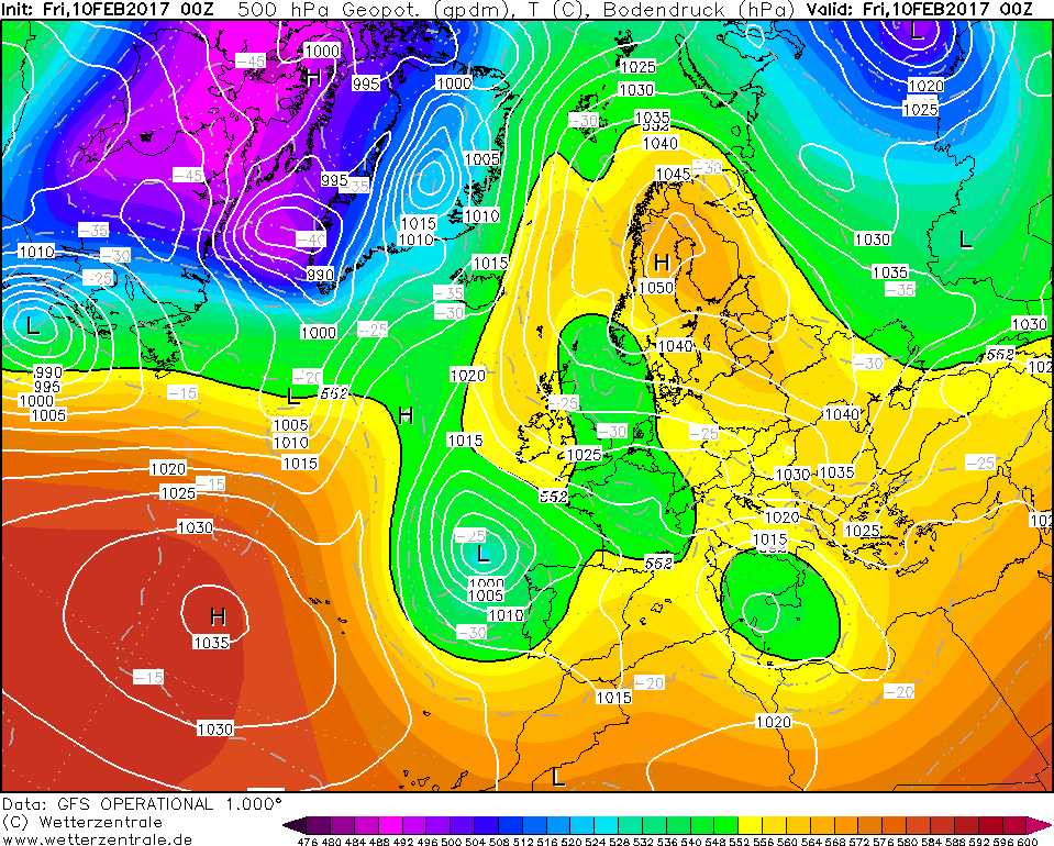
Notice a trough of LP to our east developing over the N. Sea (lake effect snow) as you can see a small kink in isobars - this brings cloud and outbreaks of light snow and or snow flurries for many parts of southern and eastern England which extending westwards across south western England too!


So what Have I /we learn't? A SSW is not necessary to get HLB. It will never guarantee it! Maybe after last years SSW we were really fortunate to see such cross model agreement and not long after as well. SO of course expectations are higher! But next time I see a SSW occur I will not be raising any hopes of HLB despite what the LONG and Shorter range models forecast. They have all been utter rubbish this winter including the Met Office? The question is why? Maybe we can discuss this in further detail when winter is over in 3 weeks time. Would be nice to have a review and to see how things went so wrong in all short and longer range models!?

Anyway! So, my point is that we really don't need a major SSW to produce HLB as it proved in Feb 2017 as well and many other snowy or cold events. I guess I am confused and can't get over the fact that we have had such a major SSW with all the right qualities as alluded to above etc but with no delivery at all anywhere.

For instance, and here is a question to anyone? Would you say last weeks brief colder snap and snowy spell for parts of the south was the tropospheric response/ result of the SSW or not? Anyone? Because surely if it was then where was the blocking? I don't think so IMO we have not seen the effects on the troposphere and the NA0 has been positive all winter. IN MY OPINION - to me, LAST Thursday night/Friday's snowy spell was more to do with fate and cold zonality and an Atlantic low pressure system colliding with colder north to north westerly air mass. BUT there was NO HLB over Greenland or Iceland/Scandinavia at all!

Keen to hear about your thoughts on this? 


Home Location - Vixen Tor Close, Okehampton, Devon (221m ASL)


Sean Moon

Magical Moon

www.magical-moon.com

jamesthemonkeh
10 February 2019 07:44:10

For instance, and here is a question to anyone? Would you say last weeks brief colder snap and snowy spell for parts of the south was the tropospheric response/ result of the SSW or not? Anyone? Because surely if it was then where was the blocking? I don't think so IMO we have not seen the effects on the troposphere and the NA0 has been positive all winter. IN MY OPINION - to me, LAST Thursday night/Friday's snowy spell was more to do with fate and cold zonality and an Atlantic low pressure system colliding with colder north to north westerly air mass. BUT there was NO HLB over Greenland or Iceland/Scandinavia at all!

Keen to hear about your thoughts on this? 


Originally Posted by: tallyho_83 

I don't think we've seen the effects of the SSW here, however I would suggest that America and Siberia...possibly parts of Asia have - it looks to my untrained stratospheric eyes that we were unlucky with the positioning of the split vortex.

I'd agree that last week's snow was more to do with cold zonality, perhaps in combination with favourable MJO forcing.

The long range models have been dreadful for the second half of the winter - even now the CFSv2 for example is forecasting extensive northern blocking for February, although it now has a strong high pressure anomaly to our east suggesting the mild, southerly flow that the GFS/ECM are forecasting.


nsrobins
10 February 2019 08:00:27
The prize for most outrageous virtual chart of the day (ECM had a decent run early Jan but drifted off course a bit) once again goes to FV3, which has persevered with the ghost set-ups impressively it has to be said.
Neil

Fareham, Hampshire 28m ASL (near estuary)

Stormchaser, Member TORRO

Brian Gaze
10 February 2019 08:20:16

C'est magnifique! (In the south and south east). 


Brian Gaze

Berkhamsted

TWO Buzz - get the latest news and views 

"I'm not socialist, I know that. I don't believe in sharing my money." - Gary Numan

beanoir
10 February 2019 08:26:10
Nice spring warming theme coming through last few days, although wet and grey comes with it by the looks

Winter tyres came off this weekend


Langford, Bedfordshire
Whether Idle
10 February 2019 08:32:13

The prize for most outrageous virtual chart of the day (ECM had a decent run early Jan but drifted off course a bit) once again goes to FV3, which has persevered with the ghost set-ups impressively it has to be said.

Originally Posted by: nsrobins 

Neil, I cant find that - can you send a link before it is replaced?


Dover, 5m asl. Half a mile from the south coast.
doctormog
10 February 2019 08:42:40


Neil, I cant find that - can you send a link before it is replaced?

Originally Posted by: Whether Idle 

http://www.wetterzentrale.de/maps/GFSPARAEU00_384_1.png 

Or more generally  http://www.wetterzentrale.de/topkarten.php?map=1&model=gfs&var=1&time=384&run=0&lid=PARA&h=0&tr=3&mv=0

(It’s also on Meteociel under “GFS Euro Para” http://www.meteociel.fr/modeles/gfse_cartes.php?runpara=1&ech=6 )


Brian Gaze
10 February 2019 08:55:37


Neil, I cant find that - can you send a link before it is replaced?

Originally Posted by: Whether Idle 

https://www.theweatheroutlook.com/twodata/gfsp.aspx?run=00&charthour=240&chartname=mslp500&chartregion=na-region&charttag=500hPa%20GPDM


Brian Gaze

Berkhamsted

TWO Buzz - get the latest news and views 

"I'm not socialist, I know that. I don't believe in sharing my money." - Gary Numan

Weathermac
10 February 2019 09:22:23

Yes doc I still have a feeling all this talk of spring may be a tad premature ...the met office update is still mainly talking of cold going forward.

Gary L
10 February 2019 10:21:26

2m mean at 9c for here on the ECM ENS late February!! 

Gusty
10 February 2019 10:28:15

Pleasant output for those now looking forward to an early Spring feel, longer days and stronger mid February UV2 (in the south) sunshine. The colder outliers are in FI where they have remained most of this autumn. 

No chart available for the selected hour. Many charts start at 3 hours ahead, so if you have 0 hours selected try stepping forward or selecting a later hour.

Things must be poor from a cold perspective...Not even David M Porter can find his way to the forum to place cold glitter on this mild turd slowly drying out in the sunshine. 


Steve - Folkestone, Kent

Current conditions from my Davis Vantage Vue

https://www.wunderground.com/dashboard/pws/IFOLKE11 

Join Kent Weather on Facebook.

https://www.facebook.com/stevewall69/ 


tallyho_83
10 February 2019 11:35:02


I don't think we've seen the effects of the SSW here, however I would suggest that America and Siberia...possibly parts of Asia have - it looks to my untrained stratospheric eyes that we were unlucky with the positioning of the split vortex.

I'd agree that last week's snow was more to do with cold zonality, perhaps in combination with favourable MJO forcing.

The long range models have been dreadful for the second half of the winter - even now the CFSv2 for example is forecasting extensive northern blocking for February, although it now has a strong high pressure anomaly to our east suggesting the mild, southerly flow that the GFS/ECM are forecasting.

Originally Posted by: jamesthemonkeh 

Exactly James! So this is what I am getting at!?

The colder snap with snow last Wed, Thursday into Friday was the result of cold zonality NOT the response from the SSW right? If so where was the HLB to be seen? - see what I mean there was never any northern blocking was there? People say there has been snow and some cold night terms and that's true - but this isn't the response the the SSW./

The true response occurred over mid western USA between the 3rd and 4th week of Jan due to HLB over northern and western Canada/ALASKA! - So the USA saw and experienced the tropospheric response NOT the UK and Europe.

Last year the SSW was around the end of the first week of Feb 18 and we saw the response around the 4th week of Feb and That response to that the SSW continued well into March when we saw repeated blocking and by the time we got into April there was a small re-positioning of the block which meant that we had out first 25c to 26c in the south and east by the 2nd - 3rd week of April 2018. Then our summer was dominate by High pressure.

BACK to the here and now looking at the 06z GFS Op run - it seems like the mean wind direction is southerly or south westerly throughout the whole run up until 26th Feb.

Gosh! - If this came about this could be the first February I can remember that has not only failed to produce an easterly or northerly but has failed to produce anything cold at all - there doesn't even seem to be a period of cold zonality either in many of these 00 and 06z runs!? Looks like today and tonight will be the coldest this month going by the 06z run. There is of course times for things to change but i am not holding my breath! 

Ps The longer range models have been performing very bad! From the UKMet Office Glosea 5, CFSv2, ECMWF, JMA, to the MeteoFrance, DWD as well as the BCC. (Beijing climate centre) - all have forecast HLB for the winter months or some models with at least one month showing northern blocking are all proving to be wrong and very wrong!!!

THAT above CFSv2 chart clearly denotes southerly winds being brought up from central and southern Europe. - SLight adjustments would mean SE winds but this Feb does look like a no go - i.e a complete write off! (as things stand!) - If we could run a sequence to illustrated how crap this February is then it's persistent HP building to our south and then as soon as it nudges further north it get's toppled over yet again! February is usually the snowiest month here where the Atlantic should be weaker (NAO) and usually the PV is a little weaker too, which would usually help to encourage HLB but this just shows that Feb 2019 will not be a wintry month anywhere in the UK. 

LOOK - SEE THE STRENGTH OF the zonal winds at 60' N. the look like they are going really positive.


Home Location - Vixen Tor Close, Okehampton, Devon (221m ASL)


Sean Moon

Magical Moon

www.magical-moon.com

David M Porter
10 February 2019 11:48:11

Pleasant output for those now looking forward to an early Spring feel, longer days and stronger mid February UV2 (in the south) sunshine. The colder outliers are in FI where they have remained most of this autumn. 

No chart available for the selected hour. Many charts start at 3 hours ahead, so if you have 0 hours selected try stepping forward or selecting a later hour.

Things must be poor from a cold perspective...Not even David M Porter can find his way to the forum to place cold glitter on this mild turd slowly drying out in the sunshine. 

Originally Posted by: Gusty 

Knowing what our climate is like, we'll probably get the cold weather at some point in the spring. How many times has that happened following a mild winter in the last 30-odd years?


Lenzie, Glasgow

"A body of men holding themselves accountable to nobody ought not to be trusted by anybody." – Thomas Paine

tallyho_83
10 February 2019 11:52:50

06z ensembles for London: - This is about as bad as it can get if you want cold and snow in a February winter month:

If this comes off we have 2 or so weeks of well above average temperatures on the surface as well as @850hpa!!


Home Location - Vixen Tor Close, Okehampton, Devon (221m ASL)


Sean Moon

Magical Moon

www.magical-moon.com

Gusty
10 February 2019 12:05:34

Knowing what our climate is like, we'll probably get the cold weather at some point in the spring. How many times has that happened following a mild winter in the last 30-odd years?

Originally Posted by: David M Porter 

That we can be sure of David. 


Steve - Folkestone, Kent

Current conditions from my Davis Vantage Vue

https://www.wunderground.com/dashboard/pws/IFOLKE11 

Join Kent Weather on Facebook.

https://www.facebook.com/stevewall69/ 


Maunder Minimum
10 February 2019 12:16:30
As Churchill put it, "Never was so much promised by so many to weather geeks with no delivery".

I know parts of the West country had a brief event recently, but other than that, this winter has been an epic fail, all the more bitter because of the constant dangling of carrots at day 10 and the "fantastic" background signals we were regularly told about.

We can draw the following conclusions however - the truism that when CONUS is a winter wonderland, Europe gets mild has been amply demonstrated once again and if the UK winter can go wrong, then it most certainly will.

Events like 1947, 1962-63 and 1981 are rare, because for the synoptic to fall right for the UK, we need more variables to fall into place than we can possibly compute at the moment. Maybe NWP will have a handle on it in another 50 years or so.


New world order coming.
White Meadows
10 February 2019 12:30:25

06z ensembles for London: - This is about as bad as it can get if you want cold and snow in a February winter month:

If this comes off we have 2 or so weeks of well above average temperatures on the surface as well as @850hpa!!

Originally Posted by: tallyho_83 

Give it up Tally. 

The nail was in the coffin way back in January anyhow.

With charts like this we can forget anything that resembles winter now, despite the Met Office persistent fairy tales:

http://www.wetterzentrale.de/en/topkarten.php?map=1&model=ecm&var=1&time=240&run=00&lid=OP&h=0&tr=24&mv=0#mapref


Gusty
10 February 2019 12:35:57

Give it up Tally. 

The nail was in the coffin way back in January anyhow.

With charts like this we can forget anything that resembles winter now, despite the Met Office persistent fairy tales:

http://www.wetterzentrale.de/en/topkarten.php?map=1&model=ecm&var=1&time=240&run=00&lid=OP&h=0&tr=24&mv=0#mapref


Originally Posted by: White Meadows 

Yes. 19th January 2019 to be precise. 

That easterly carrot got dangled as close as 144 hours before being snatched away.

A few stalwarts hung around for another 2 or 3 weeks in search of the eastern promise. In their heart of hearts even they probably realised it was another opportunity gone begging.

I sense the mood in here now changing towards Spring mode. 


Steve - Folkestone, Kent

Current conditions from my Davis Vantage Vue

https://www.wunderground.com/dashboard/pws/IFOLKE11 

Join Kent Weather on Facebook.

https://www.facebook.com/stevewall69/ 


Remove ads from site