Remove ads from site
Also the growing signal for the weakening strat vortex is demonstrated on the Hannah attard site well...
Everything going well at the moment ...
ECM 00z ensemble for London is broadly consistent with yesterday's 00z and 12z
Still a clear signal for a cooling trend starting next weekend. Towards the end of the run rather more scatter has appeared but the colder variants still dominate.
130 metres ASL
52.0N 0.1E
It's a no to the southerly tracking jet on the 6z but a yes to the Westward march of low heights into Europe, so interesting to see what subsequent runs show.
Originally Posted by: Shropshire
I haven't seen a southerly tracking jet in the recent output.
Originally Posted by: Gandalf The White
A good time to remind everyone that we have the full ECM 15-day ensemble data, including charts for each of the members and all sorts of parameters, here:
https://weather.us/forecast/2639577-reading/ensemble/euro
GFS 12z once again brings a plume of WAA and pumps up a blocking high to our north.
Here at T+216
Beyond that the block retrogresses and the PV migrates to the Russian side of the Pole. Here is the T+300 view
GFS still toying with some pretty meaty blocking in places, something’s afoot for sure.
Originally Posted by: JACKO4EVER
Agreed. The outlook now is certainly looking a bit more interesting than appeared to be the case just a few days ago.
"A body of men holding themselves accountable to nobody ought not to be trusted by anybody." – Thomas Paine
FI charts are not without interest.
Originally Posted by: David M Porter
Hi David,
There's a tendency in here to assume that when a zonal pattern develops that somehow it will endure for weeks. It wasn't that long ago that the charts were full of upper heights to our north, then the models picked up a surge in the jetstream and the pattern changed. Now, after only a couple of weeks it looks as if blocking could be back in play.
Yes big flip to cold in the output over the last 24hrs . Can we count down this cold spell to the more reliable 72/96h range I stil have my doubts.
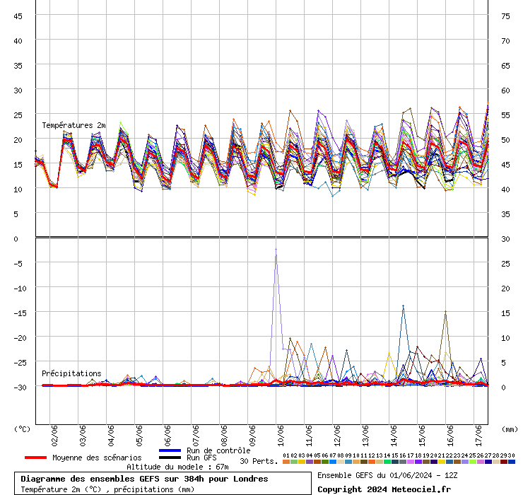
GFS 12z ensemble for London
Heights to the NW....showing retogression ....if we can keep low heights over Spain...(re 240 hrs).....things may look somewhat interesting in the Christmas runup...lots to observe...but a timeframe challenge ...as always...
We have been in so so many times before. I'm almost minded to disregard it.
See you back here for the ECM run at 7ish.
Current conditions from my Davis Vantage Vue
https://www.wunderground.com/dashboard/pws/IFOLKE11
Join Kent Weather on Facebook.
https://www.facebook.com/stevewall69/
Originally Posted by: Gusty
Cynic.
More angles from th GFS ensemble
Wind direction - showing the strong support for winds from the north then backing north-east
Surface temperatures (2m):
Certainly improving ensembles, the wind direction one is useful
240m/785 ft asl
Early days though - we’ve been here many times before.
Fareham, Hampshire 28m ASL (near estuary)
Stormchaser, Member TORRO
The colder scenario from 9th has gained some momentum with the 12Z outputs - with a good 3deg shift colder in the GEFS mean. Early days though - we’ve been here many times before.
Originally Posted by: nsrobins
Yes we have. Are we being led up the garden path or does it lead to a winter wonderland?
Meanwhile, ECM also pushes a plume of WAA up but has it a little further east at T+216, keeping the core of the colder air just to our east on this run.
Indeed. These developments are quick but more often than not end up sending the coldest air through central Europe. Good trends for a colder and more settled outlook though.
The last frame of the EC actually supeised me - I was expecting the high to sink SE but a new push of warmer air aloft to our west has kept it in situ.
Err - interesting.
Been fun watching the GFS drop any kind of settled interlude for early/mid December only for it to reappear over the last few runs
A quick snapshot of the ens at T216 says it's extremely confident that HP will be influencing the UK - at this stage there's a strong signal for the block to be essentially over the UK, meaning quiet and increasingly chilly at the surface or just to the North, allowing for colder air to be dragged in for some.
ECM Op isn't out of step with quite a few of the GFS members, suggesting a period of HP influenced weather is strongly favoured. No doubt they'll be some ups and downs as the ops play out different scenarios in FI. In terms of getting a proper cold spell (i.e -10 850s and some snow about) that's not a favoured option with only a few of the members (and the Op and Control which is nice to see) going for it in the GFS ens but it is there so with luck who knows?
All in all nice to see if you like cold or if you just fancy a break from the current wet and breezy stuff
Work: Tonbridge
12z GEFS.
A colder and drier theme is emerging for next week. For coldies encouragement should be drawn from the fact that both the operational and control are at the coldest end of the suite.
ECM ensembles not as cold as the GEFS. GFS hasn't been great recently hopefully this time its ahead of the ECM.