The Weather Outlook

Remove ads from site

Hippydave
28 December 2016 18:25:05

Interesting 12z ens

The Op manages to be largely warmest throughout (850s) and an outlier for pressure later on too (one of the highest) and to complete the set warmest T2M temps later on.

There's some notable cold clustering in the last third or so of the run with a number of members giving ice days

Deep FI and all that but encouraging none the less. One thing is sure it's not a warm and zonal run and there's clearly good potential for further cold weather later on, after the upcoming cold snap subsides.


Home: Tunbridge Wells

Work: Tonbridge

yorkshirelad89
28 December 2016 18:26:49

The ensembles represent an upgrade. Although the OP isnt anything special a fair few members develop serious heights over Greenland. The control in particular is cold.

Best of the lot though is P4 which is an absolute stunner. A massive Greenland high leaves an unstable air mass over the UK and at one point we get -15C uppers over the UK. January 1881 esque


http://www.wetterzentrale.de/maps/GFSP04EU12_300_1.png

http://www.wetterzentrale.de/maps/GFSP04EU12_300_2.png

 We can dream...lol

The number of cold runs is increasing however, lets hope the ECM provides a christmas cracker!


Hull
marting
28 December 2016 18:40:51

The ensembles represent an upgrade. Although the OP isnt anything special a fair few members develop serious heights over Greenland. The control in particular is cold.

Best of the lot though is P4 which is an absolute stunner. A massive Greenland high leaves an unstable air mass over the UK and at one point we get -15C uppers over the UK. January 1881 esque


http://www.wetterzentrale.de/maps/GFSP04EU12_300_1.png

http://www.wetterzentrale.de/maps/GFSP04EU12_300_2.png

 We can dream...lol

The number of cold runs is increasing however, lets hope the ECM provides a christmas cracker!

Originally Posted by: yorkshirelad89 

yes a good upgrade this evening. Some wonderful charts that would deliver just about everywhere. Trying to pin point where the operational gfs moves away from the pack. ECM looking consistent again.

martin


Martin

Greasby, Wirral.

nsrobins
28 December 2016 18:54:39
The ECM has a better second shot akin to a few of the GEFS so there's still plenty to watch over the next few days - plus the first CF may yet spring a few surprises.
Neil

Fareham, Hampshire 28m ASL (near estuary)

Stormchaser, Member TORRO

David M Porter
28 December 2016 18:56:15

I've seen worse charts than this in my time:

http://old.wetterzentrale.de/pics/Recm2161.html


Lenzie, Glasgow

"A body of men holding themselves accountable to nobody ought not to be trusted by anybody." – Thomas Paine

Saint Snow
28 December 2016 19:00:02

The Ens for Liverpool suggests a decent chance of back-edge snow IMBY during the first cold pulse as we go into 2nd Jan. 13 members in the 'snow row' isn't to be sniffed at!


Martin

Home: St Helens (26m asl) Work: Manchester (75m asl)

A TWO addict since 14/12/01

"How can wealth persuade poverty to use its political freedom to keep wealth in power? Here lies the whole art of Conservative politics."

Aneurin Bevan

Hippydave
28 December 2016 19:00:46

Mild outlier

Looks alright I guess!


Home: Tunbridge Wells

Work: Tonbridge

Brian Gaze
28 December 2016 19:01:41

ECM12z is a bonechiller tonight. We now have the BEST chance of a genuine nationwide cold spell since 2012/13.


Brian Gaze

Berkhamsted

TWO Buzz - get the latest news and views 

"I'm not socialist, I know that. I don't believe in sharing my money." - Gary Numan

Ally Pally Snowman
28 December 2016 19:02:13

I've seen worse charts than this in my time:

http://old.wetterzentrale.de/pics/Recm2161.html

Originally Posted by: David M Porter 


Yes truly stunning end to the ecm. Great output tonite but it's a waiting game for the mega charts .


http://old.wetterzentrale.de/pics/Recm2401.html


Bishop's Stortford 85m ASL.
GIBBY
28 December 2016 19:03:44

Now even I'm getting more interested. This chart is much more what I've been looking for even better as it comes from my preferred model. Note the undercut out of the states can only go under the High because of its blocking attributes further North than recently. Further out charts would probably show a Southerly positioned Jet flow across the Atlantic towards Iberia which could feed a battleground scenario from the SW longer term. A long way out but this chart offers a real chance of a substantial cold outbreak from that setup. Let's hope the ensembles later show a shift towards a similar evolution and this better orientation and position of the High pressure is maintained over up and coming runs.

http://old.wetterzentrale.de/pics/Recm2401.gif


Martin G

Kilmersdon Radstock Bath Somerset

Look up my New Facebook Weather Page  for all the latest up to the minute weather stories as they happen
Gusty
28 December 2016 19:08:46

Stunning ECM 240 hours. 

We would all be very rich if we had a pound for every time its been said this year.


Steve - Folkestone, Kent

Current conditions from my Davis Vantage Vue

https://www.wunderground.com/dashboard/pws/IFOLKE11 

Join Kent Weather on Facebook.

https://www.facebook.com/stevewall69/ 


Chunky Pea
28 December 2016 19:12:40

Not one for 'pattern matching' but the ECM chart at 144 reminded me a little of that which occurred just the before the 'big one' back in Dec '10.

2010
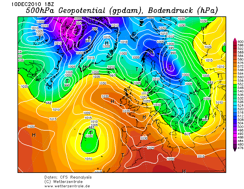
 

Tonight's ECM at 144hrs:
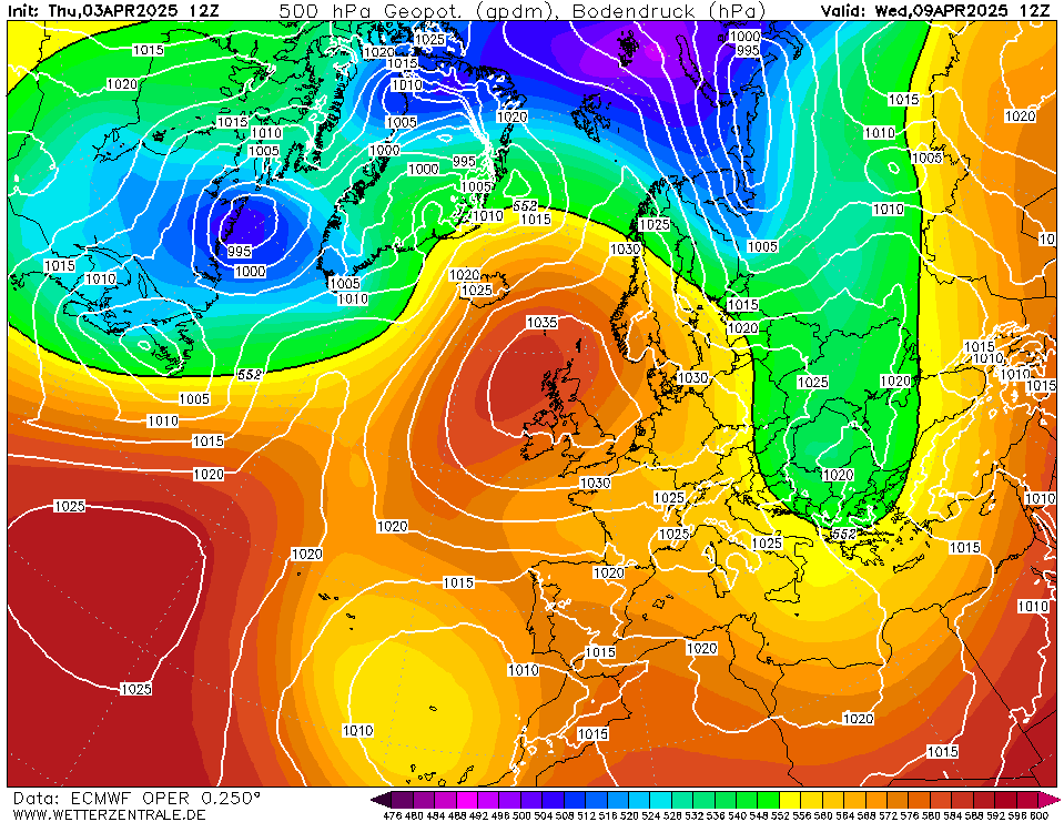
 

Of course, on a synoptic scale, many differences to be had, but on a sub-synoptic scale, maybe not so many.


Patrick,

East Galway, Ireland.

Solar Cycles
28 December 2016 19:14:50
Well the ECM pulls a rabbit out of the hat now we just need to see how it sits within the ENS, thereafter some much needed consistency required. All in all the pointers look good towards the close of play just the pub run now and hopefully some cross model agreement in the days ahead.🙂
Bertwhistle
28 December 2016 19:19:21

Well the ECM pulls a rabbit out of the hat now we just need to see how it sits within the ENS, thereafter some much needed consistency required. All in all the pointers look good towards the close of play just the pub run now and hopefully some cross model agreement in the days ahead.🙂

Originally Posted by: Solar Cycles 

A good positive, but rightly cautious, comment.

GFS ENS takes a dodgy rise after this fairly-nailed-on dip in 850 temps; hence caution is preferable.


Bertie, Itchen Valley.

Retire while you can still press the 'retire now' button.

Gandalf The White
28 December 2016 19:19:25

Now even I'm getting more interested. This chart is much more what I've been looking for even better as it comes from my preferred model. Note the undercut out of the states can only go under the High because of its blocking attributes further North than recently. Further out charts would probably show a Southerly positioned Jet flow across the Atlantic towards Iberia which could feed a battleground scenario from the SW longer term. A long way out but this chart offers a real chance of a substantial cold outbreak from that setup. Let's hope the ensembles later show a shift towards a similar evolution and this better orientation and position of the High pressure is maintained over up and coming runs.

http://old.wetterzentrale.de/pics/Recm2401.gif

Originally Posted by: GIBBY 

The other feature to note is that the WAA is flowing north, i.e. it's not toppling under pressure from the jet, which looks to be split with what appears to be more energy in the southern arm.

It's a variation on the recent theme; as SC says, we need to see where this evolution sits in the ensemble suite.


Location: South Cambridgeshire

130 metres ASL

52.0N 0.1E


David M Porter
28 December 2016 19:19:36

Not one for 'pattern matching' but the ECM chart at 144 reminded me a little of that which occurred just the before the 'big one' back in Dec '10.

2010


Tonight's ECM at 144hrs:


Of course, on a synoptic scale, many differences to be had, but on a sub-synoptic scale, maybe not so many.

Originally Posted by: Chunky Pea 

Those two charts don't look at all dissimilar, do they!


Lenzie, Glasgow

"A body of men holding themselves accountable to nobody ought not to be trusted by anybody." – Thomas Paine

Whether Idle
28 December 2016 19:21:07

Well the ECM pulls a rabbit out of the hat now we just need to see how it sits within the ENS, thereafter some much needed consistency required. All in all the pointers look good towards the close of play just the pub run now and hopefully some cross model agreement in the days ahead.🙂

Originally Posted by: Solar Cycles 

Post of the day. 👍


Dover, 5m asl. Half a mile from the south coast.
doctormog
28 December 2016 19:22:47
Well at least there is plenty to talk about! Whether anything of significance comes to fruition remains to be seen but at least it might look like winter at times, with the potential for more. The ECM run fits into the broad pattern of things quite nicely and has been much more consistent an the GFS in the longer term. An interesting few days coming up.
David M Porter
28 December 2016 19:24:40

Well the ECM pulls a rabbit out of the hat now we just need to see how it sits within the ENS, thereafter some much needed consistency required. All in all the pointers look good towards the close of play just the pub run now and hopefully some cross model agreement in the days ahead.🙂

Originally Posted by: Solar Cycles 

Well said SC.


Lenzie, Glasgow

"A body of men holding themselves accountable to nobody ought not to be trusted by anybody." – Thomas Paine

JACKO4EVER
28 December 2016 19:33:27
Two stabs at a northerly, the best one sadly out in FI.

Interesting output though we need to see where this fits in the ensembles- perhaps time for an ensemble watch ? 😀

sizzle
28 December 2016 19:54:26

GavsWeatherVids ‏@GavinPartridge 3m3 minutes ago

Have updated the Blog - We're looking at the latest UKMO Contingency Planners Guidance covering January-March 2017

moomin75
28 December 2016 19:59:20

GavsWeatherVids ‏@GavinPartridge 3m3 minutes ago

Have updated the Blog - We're looking at the latest UKMO Contingency Planners Guidance covering January-March 2017

Originally Posted by: sizzle 

That's not the greatest update really. Above average predominantly doesn't float my boat.


Witney, Oxfordshire

100m ASL

pdiddy
28 December 2016 20:28:39

That's not the greatest update really. Above average predominantly doesn't float my boat.

Originally Posted by: moomin75 

Agreed, but the MetO forecast has hardly been spot on in recent times.  I'm inclined not to place too much faith in the longer term forecasts and look at the usual model runs and evolving background signals.

sizzle
28 December 2016 20:30:30

TBH after reading the latest UKMO Contingency Planners Guidance I got this horrible feeling and that the uncertainty of this cold spell is going to go TITS UP..........

the latest BBC weather only just said turning chillier and more settled as we head into the new year...................

sizzle
28 December 2016 20:37:26

part of a matt hugo tweet........... from what I've seen last month wQBO set to dominate throughout until late winter  [ no idea what he means, but don't sound good to me,


Remove ads from site