The Weather Outlook

Remove ads from site

Rob K
27 June 2025 16:25:31

Arpege suggests a chance of a new Dutch national record on Tuesday. Current record is 40.7C.


Yateley, NE Hampshire, 73m asl

"But who wants to be foretold the weather? It is bad enough when it comes, without our having the misery of knowing about it beforehand." — Jerome K. Jerome

Ally Pally Snowman
27 June 2025 16:32:04

Arpege suggests a chance of a new Dutch national record on Tuesday. Current record is 40.7C.

Originally Posted by: Rob K 

Also 35c on Monday and 36c on Tuesday for here.


Bishop's Stortford 85m ASL.
Retron
27 June 2025 17:03:24

The 76 record will stand then which shows how hot it managed to get back then with a 1.5 degree lower baseline and cooler oceans than at present .

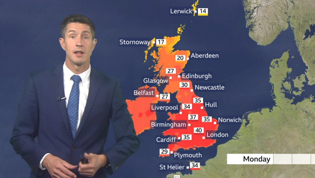
 If the June 76 heatwave happened now i am not sure what colour the BBC charts would be as 25 seems to qualify for quite a dark red and the hyperbole in the news is deeply disturbing but not for the fact that there will be a short heatwave

Originally Posted by: bledur 

FWIW in this part of Kent June will have been overwall warmer than the same month in 1976. I'm glad I wasn't alive then to experience the rest of that summer!

As for what 35 would look like on the BBC charts, well, we know that from a couple of years ago. 

https://ukwct.org.uk/weather/2022.jpg 

UserPostedImage

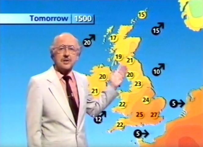
They've always had red on the colour chart, but it used to only appear for 40C or higher - so was never seen in the vicinity of the UK. They apparently moved the "red range" back to increase contrast from the yellows and oranges previously used, but as I'm not partially sighted I can't comment on how effective that is. Here's a screengrab from August 1990 - I had a wistful sigh watching it again, as Michael Fish described 27C in London in August as being "hot". Ahh... these days of course it'd just be "warm", not even "very warm"!

UserPostedImage

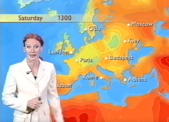
EDIT: Here's the full "hot" scale in the old days, courtesy of our own Kevin Bradshaw! The deep reds are 40+:

https://ukwct.org.uk/weather/2000.jpg 

UserPostedImage

Second EDIT: The GFS is up to its usual tricks. 34s here for Monday and Tuesday, but then a deluge afterwards. I've never seen so much rain forecast on an op run away from the mountains, here's the view from xcweather:

https://ukwct.org.uk/weather/xc.jpg 

UserPostedImage

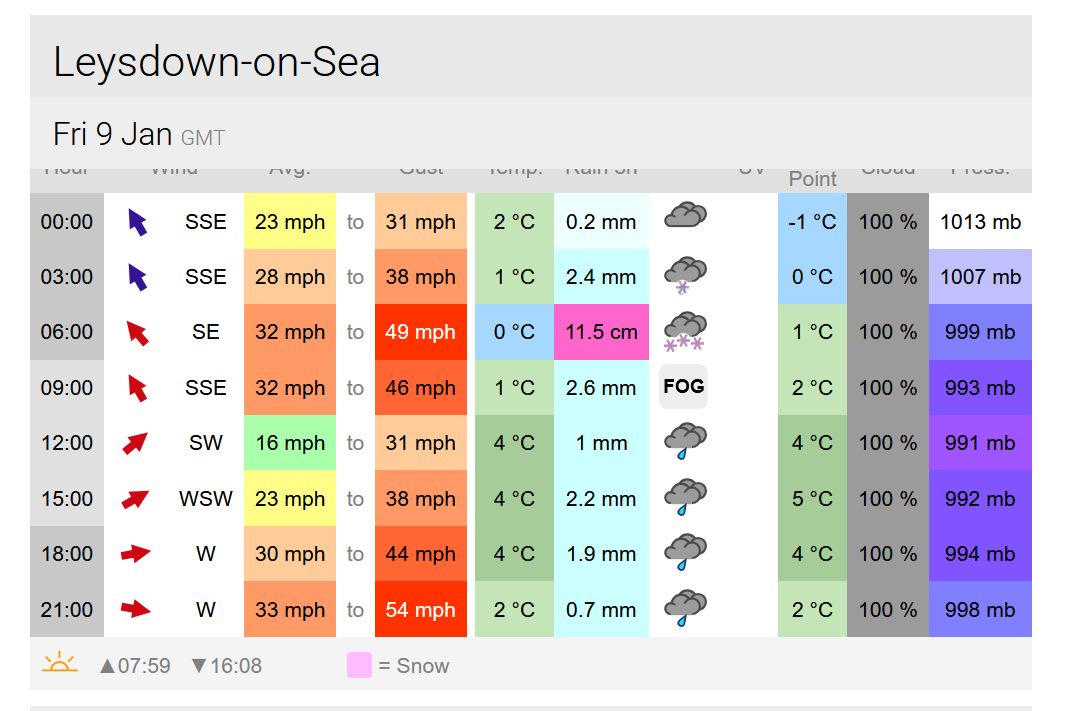
I don't know what's less likely to happen... two inches of rain in the afternoon/evening, or a solar noon temperature of just 17C. I'd suspect neither will happen in the end!


Leysdown, north Kent
Brian Gaze
27 June 2025 17:05:26

A number of model runs have shown this type of development occurring next week. As well as potentially producing significant rain in central and eastern areas, the temperature contrast with earlier in the week is striking. A 9°C maximum in central Britain would be something!

  UserPostedImage

UserPostedImage


Brian Gaze

Berkhamsted

TWO Buzz - get the latest news and views 

"I'm not socialist, I know that. I don't believe in sharing my money." - Gary Numan

johncs2016
27 June 2025 17:11:23

A number of model runs have shown this type of development occurring next week. As well as potentially producing significant rain in central and eastern areas, the temperature contrast with earlier in the week is striking. A 9°C maximum in central Britain would be something!

  UserPostedImage

UserPostedImage

Originally Posted by: Brian Gaze 

That is not in any way going to help the farmers in those parts of NE Scotland which are still at moderate water scarcity status according to SEPA, especially if that rain doesn't even make it Scotland at all.


The north of Edinburgh, usually always missing out on snow events which occur not just within the rest of Scotland or the UK, but also within the rest of Edinburgh.

moomin75
27 June 2025 17:22:36

A number of model runs have shown this type of development occurring next week. As well as potentially producing significant rain in central and eastern areas, the temperature contrast with earlier in the week is striking. A 9°C maximum in central Britain would be something!

  UserPostedImage

UserPostedImage

Originally Posted by: Brian Gaze 

The low maximas next week have shown up quite a lot on GFS. I do think we are in for it after this hot spell finishes, and face a fairly lengthy cool and changeable spell.


Witney, Oxfordshire

100m ASL

bledur
27 June 2025 17:36:36

The warmer oceans increase humidty in the atmosphere, which likely is preventing maxima from reaching or breaking record levels (it is easier to heat dry air than wet), but it is also harder to cool down wetter air, hence why minima is rising generally more quickly than max temps generally speaking. I don't think record breaking max temps ae an indication of climate change, but the weight of warmer than normal temps over time most certainly are. 

Originally Posted by: Chunky Pea 

Not in an isolated incident maybe but they definitely are at the frequency they are occurring

https://www.metoffice.gov.uk/blog/2025/scorching-junes-how-often-do-we-see-temperatures-over-30c-in-june 

bledur
27 June 2025 17:38:20

A number of model runs have shown this type of development occurring next week. As well as potentially producing significant rain in central and eastern areas, the temperature contrast with earlier in the week is striking. A 9°C maximum in central Britain would be something!

  UserPostedImage

UserPostedImage

Originally Posted by: Brian Gaze 

No good to me . Move that rain further south please.😄

Brian Gaze
27 June 2025 17:42:37

No good to me . Move that rain further south please.😄

Originally Posted by: bledur 

As Darren said, the GFS 12Z shows a deluge in the south when the heat breaks.

UserPostedImage


Brian Gaze

Berkhamsted

TWO Buzz - get the latest news and views 

"I'm not socialist, I know that. I don't believe in sharing my money." - Gary Numan

Rob K
27 June 2025 18:02:57

The low maximas next week have shown up quite a lot on GFS. I do think we are in for it after this hot spell finishes, and face a fairly lengthy cool and changeable spell.

Originally Posted by: moomin75 

Based on the output I have seen I don't think cool and changeable is the most likely picture - it seems like high pressure centred just to the west of the UK is favourite by the second week of July, so fairly settled but less warm than of late.


Yateley, NE Hampshire, 73m asl

"But who wants to be foretold the weather? It is bad enough when it comes, without our having the misery of knowing about it beforehand." — Jerome K. Jerome

Bertwhistle
27 June 2025 18:07:13

I was at school in Southampton that day and (not knowing aged 11 the rules about temperature measurement) remember going repeatedly back to our in-the-sun thermometer attached to the hut. It read over 120F and was facing laterally so not towards the June sun.

Maybe some don't realise the record was broken 3 times in 3 days- 34.9 on 26th, then 35.5 then 35.6C.  This was all in Mayflower Park which I knew well and was decommissioned around 1999/2000. It was notorious for sea breezes ruining the max some days, but in E /NElies the air came across the town first and gave some anomalous temperatures. For whatever reason, there were no sea breezes on these 3 record days. On a school trip around then we were all hiding in a concrete cylinder in the Mayflower Park  playground from the ladybirds. Didn't work.


Bertie, Itchen Valley.

Retire while you can still press the 'retire now' button.

bledur
27 June 2025 18:07:30

The low maximas next week have shown up quite a lot on GFS. I do think we are in for it after this hot spell finishes, and face a fairly lengthy cool and changeable spell.

Originally Posted by: moomin75 

Are you in the Umbrella business? 🤣

speckledjim
27 June 2025 18:10:05

Are you in the Umbrella business? 🤣

Originally Posted by: bledur 

Every year it's the same forecast from Moomin. I don't comment on the models as I don't have the expertise, he should follow suit.


Thorner, West Yorkshire


Journalism is organised gossip

bledur
27 June 2025 18:10:12

I was at school in Southampton that day and (not knowing aged 11 the rules about temperature measurement) remember going repeatedly back to our in-the-sun thermometer attached to the hut. It read over 120F and was facing laterally so not towards the June sun.

Maybe some don't realise the record was broken 3 times in 3 days- 34.9 on 26th, then 35.5 then 35.6C.  This was all in Mayflower Park which I knew well and was decommissioned around 1999/2000. It was notorious for sea breezes ruining the max some days, but in E /NElies the air came across the town first and gave some anomalous temperatures. For whatever reason, there were no sea breezes on these 3 record days. On a school trip around then we were all hiding in a concrete cylinder in the Mayflower Park  playground from the ladybirds. Didn't work.

Originally Posted by: Bertwhistle 

It really was an amazing spell ,but like you mention , the very local  conditions boosted the temps in that area.

Rob K
27 June 2025 18:27:59

It really was an amazing spell ,but like you mention , the very local  conditions boosted the temps in that area.

Originally Posted by: bledur 

It would be interesting to see what the maxima were at other stations during that spell. The Monthly Weather report shows 34.2 at Kew and Cardington, 34.1 at Thorney Island and a record 34.8C at London Weather Centre (which I believe was a rooftop site?).


Yateley, NE Hampshire, 73m asl

"But who wants to be foretold the weather? It is bad enough when it comes, without our having the misery of knowing about it beforehand." — Jerome K. Jerome

Bertwhistle
27 June 2025 19:02:51

As expected, it's a bit of an outlier though.

I am fairly sure after today, we won't see anything near as warm for a couple of weeks.

Time will tell.

Originally Posted by: moomin75 

Glad you were only fairly sure.


Bertie, Itchen Valley.

Retire while you can still press the 'retire now' button.

Brian Gaze
27 June 2025 19:45:29

GFS Op stands out like a sore thumb. 

UserPostedImage


Brian Gaze

Berkhamsted

TWO Buzz - get the latest news and views 

"I'm not socialist, I know that. I don't believe in sharing my money." - Gary Numan

27 June 2025 20:18:35

The low maximas next week have shown up quite a lot on GFS. I do think we are in for it after this hot spell finishes, and face a fairly lengthy cool and changeable spell.

Originally Posted by: moomin75 

Like the one now?

🤣🤣🤣


Berkshire
idj20
27 June 2025 20:26:00
I, too, am seeing that strange set up for latter half of next week where it'll be raining and 17 C feeling cold in a strong NE wind over Kent, while not even 200 miles to my south east could see 100 F temperatures. I do recall experiencing this stark contrasting conditions before where the charts was showing 22 C uppers but it felt autumnal cold 15 C under strong wind in from the North Sea, it's like the Summer equivalence of a frustrating so-near-and-yet-so-far north east airflow set up in mid Winter. 
Home location: Folkestone Harbour.
briggsy6
27 June 2025 20:42:01

Can someone please answer a question re. this upcoming hot spell. I have heard some forecasters say it is due to hot air being drawn up from the near continent and another (Carol Kirkwood?) say it is due to a heatwave in America which has now travelled across the Atlantic Ocean. Which is correct?


Location: Uxbridge
Essan
27 June 2025 20:44:06

The low maximas next week have shown up quite a lot on GFS. I do think we are in for it after this hot spell finishes, and face a fairly lengthy cool and changeable spell.

Originally Posted by: moomin75 

To balance out a high of 35c we need a high of 7c  (given an average max for time of year of 21c)  😉       It won't be that cool.


Andy

Evesham, Worcs, Albion - 35m asl

Weather & Earth Science News 

Look in the doubt we've wallowed, look at the leaders we've followed, look at the lies we've swallowed, and I don't want to hear no more

Essan
27 June 2025 20:48:10

Can someone please answer a question re. this upcoming hot spell. I have heard some forecasters say it is due to hot air being drawn up from the near continent and another (Carol Kirkwood?) say it is due to a heatwave in America which has now travelled across the Atlantic Ocean. Which is correct?

Originally Posted by: briggsy6 

Both

The current warm air is being drawn across the Atlantic from the USA heat dome.    Over the weekend this becomes less influential, but additional heat will push up from the Spanish heat dome.


Andy

Evesham, Worcs, Albion - 35m asl

Weather & Earth Science News 

Look in the doubt we've wallowed, look at the leaders we've followed, look at the lies we've swallowed, and I don't want to hear no more

briggsy6
27 June 2025 21:22:19

So we are being "attacked" from two sides. Maybe this explains why the temps are going to be so high, including the dry ground situation we are currently facing. 


Location: Uxbridge
Gandalf The White
27 June 2025 21:27:56

GFS Op stands out like a sore thumb. 

UserPostedImage

Originally Posted by: Brian Gaze 

I have been watching the potential for a significant rainfall event around the middle of next week.  ECM was showing it for several runs before it briefly disappeared but it has now returned with a vengeance: ECM has around 50-75mm over a 24-36 hour period across East Anglia and the South East, GFS has it slightly later and a little further south-east.  Definitely something to watch because that sort of intensity and duration would cause issues.


Location: South Cambridgeshire

130 metres ASL

52.0N 0.1E


Downpour
27 June 2025 21:38:37

Are you in the Umbrella business? 🤣

Originally Posted by: bledur 

Kieran is one of the golden greats of this forum. But this comment made me laugh. 


Chingford

London E4

147ft

Remove ads from site