The Weather Outlook

Remove ads from site

Gooner
19 December 2021 21:28:53


I'd probably go something like 60:40 in favour of a fairly average or milder scenario predominating from the middle of the coming week with the exception of a few colder days around 27/12. I don't ever bet on anything, but gut feel remains for an anomalously cold period in late Jan or the first half of Feb. 

Originally Posted by: Brian Gaze 

Think many would settle for that 


Remember anything after T120 is really Just For Fun


Marcus

Banbury

North Oxfordshire

378 feet A S L


Whether Idle
19 December 2021 21:41:12

I believe we’re losing this one in increments. It will be remarkable if the synoptics recover to something like those being shown two days ago. Greenland high is draining and the ever-present high to our south is exerting it’s influence. For next weekend to be ‘rescued’ for the majority of the UK we’ve got until the 00Z runs Tues am.
I’m still a bit puzzled as to why such promising signals have eroded over just 24hrs, but the weather has a tendency to puzzle and amaze.

Originally Posted by: nsrobins 

I share your puzzlement to some degree.  The high N / NW needs to stand up and assert itself.  Its not game over yet but time is running out for the models to pick up on a strong lobe of that high to stick southwards to Scotland towards Christmas Eve/XMas Day.


Dover, 5m asl. Half a mile from the south coast.
fairweather
19 December 2021 21:42:08

Actually, for great swathes of the UK at present, if you can get yourself up a few hundred feet, there is a stunning temperature inversion. It’s in the Peak, the Lake District, Central Scotland, and more. Fabulous atmospheric clarity as well.

Originally Posted by: buachaille 

We don't have "a few hundred feet" up in Essex 


S.Essex, 42m ASL
Gooner
19 December 2021 22:09:47

Looking marginally better I'd say

Cold air a tad further South also 


Remember anything after T120 is really Just For Fun


Marcus

Banbury

North Oxfordshire

378 feet A S L


Gooner
19 December 2021 22:14:41

Different at 138h , just goes to show the uncertainty 


Remember anything after T120 is really Just For Fun


Marcus

Banbury

North Oxfordshire

378 feet A S L


Gandalf The White
19 December 2021 22:16:19

Different at 138h , just goes to show the uncertainty 

Originally Posted by: Gooner 

The cold air is about 100 miles further south on this run. A tiny adjustment in global terms but hugely important if you’re somewhere in that 100 miles.


Location: South Cambridgeshire

130 metres ASL

52.0N 0.1E


BJBlake
19 December 2021 22:16:55

Agreed, this is looking like it could be a good pub run. What I cannot see - is any energy in the Jet heading our way, which should leave it open for that small northern arm, oddly diving from NNE to SSW, potentially the gate is open  to an Arctic plunge...
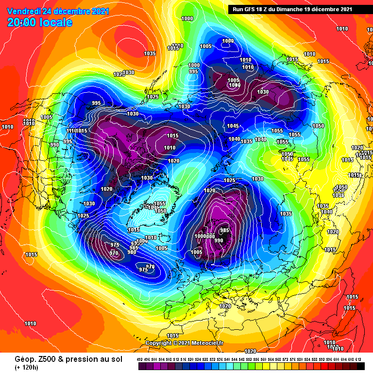
Looking marginally better I'd say
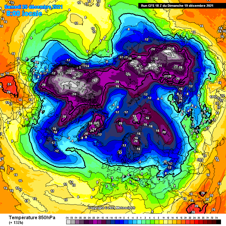
Cold air a tad further South also 

Originally Posted by: Gooner 


Brecklands, South Norfolk 28m ASL
Rob K
19 December 2021 22:17:55
At 150 hours the GFS is massively different to the last run. The low pressure to the south is nowhere to be seen. Amazing changes at short notice.
Yateley, NE Hampshire, 73m asl

"But who wants to be foretold the weather? It is bad enough when it comes, without our having the misery of knowing about it beforehand." — Jerome K. Jerome

Gandalf The White
19 December 2021 22:19:19

What a huge change in the synoptics by T+144 compared to the 12z. The main LP centre is stuck south of Greenland instead of off the SW of England.


Location: South Cambridgeshire

130 metres ASL

52.0N 0.1E


Gooner
19 December 2021 22:20:01

Not a done deal by any means 


Remember anything after T120 is really Just For Fun


Marcus

Banbury

North Oxfordshire

378 feet A S L


Rob K
19 December 2021 22:21:28
What seems to be happening is that from 120 hours the eastern lobe of low pressure to the west just gets sucked back into the main circulation instead of heading east and cutting off the cold air.
Yateley, NE Hampshire, 73m asl

"But who wants to be foretold the weather? It is bad enough when it comes, without our having the misery of knowing about it beforehand." — Jerome K. Jerome

BJBlake
19 December 2021 22:26:38

What seems to be happening is that from 120 hours the eastern lobe of low pressure to the west just gets sucked back into the main circulation instead of heading east and cutting off the cold air.

Originally Posted by: Rob K 

Yes - this is a major change. The juggernaut southern arm of the jet does reach us at T150, but has lost any northerly thrust, and dives off harmlessly to the south, leaving the cold air in place - and any little low running along the northern edge of the jet might well engage with that cold air, and a snow fest might be back on the cards...all to play for.


Brecklands, South Norfolk 28m ASL
Rob K
19 December 2021 22:26:38
Dartboard low reminiscent of the UKMO 168 chart
Yateley, NE Hampshire, 73m asl

"But who wants to be foretold the weather? It is bad enough when it comes, without our having the misery of knowing about it beforehand." — Jerome K. Jerome

Polar Low
19 December 2021 22:28:43

You might get lucky Marcus Snow into Midlands on this run

https://www.theweatheroutlook.com/twodata/gfs.aspx?run=18&charthour=153&chartname=preciptype&chartregion=uk&charttag=Precip%20type


Looking marginally better I'd say

Cold air a tad further South also 

Originally Posted by: Gooner 

Brian Gaze
19 December 2021 22:29:13

Huge temperature gradient on the 18z


Brian Gaze

Berkhamsted

TWO Buzz - get the latest news and views 

"I'm not socialist, I know that. I don't believe in sharing my money." - Gary Numan

White Meadows
19 December 2021 22:29:38
Good old GFS has been barking up the wrong tree, very over progressive with the Atlantic activity. As we draw closer it should start to model detail a tad better.

Hopefully a channel low can be achieved as shown here.

Rob K
19 December 2021 22:30:13
Still needs a bit more of a southwards adjustment to get the snow into the south.
Yateley, NE Hampshire, 73m asl

"But who wants to be foretold the weather? It is bad enough when it comes, without our having the misery of knowing about it beforehand." — Jerome K. Jerome

ballamar
19 December 2021 22:34:27
Being on the wrong side in the south whilst Midlands north is quite a likely scenario ! Been there many times
UncleAlbert
19 December 2021 22:35:02
True irony, ICON was the bad boy last night.

Could it be now leading the rally?

tallyho_83
19 December 2021 22:44:19

So I have come to a conclusion as to why so many models fail and hence the constant downgrades in model outputs!? - It's because we have a warmer than average Atlantic SST which is constantly fueling up the jet even more - prime example will be around +162z as seen on 18z GFS op run:

Low pressure begins to develop around the Azores at +162z despite cold air to our north and north east pushing southwards: 

By +174z this Low pressure system intensifies.

By +192z - it's into the UK and passed - thus flattening any ridge/block trying to build at the same time yet another LP system develops off the eastern seaboard of Canada. It's like we are getting cyclongenisis!? 

This is all occurring despite Greenland blocking and a -ive NAO etc.

So it's due to the well about SST's in the Atlantic which could be ramping up our storms and perhaps flattening ridges that attempt to build!?


Home Location - Vixen Tor Close, Okehampton, Devon (221m ASL)

---------------------------------------

Sean Moon

Magical Moon

www.magical-moon.com

BJBlake
19 December 2021 22:44:48

GFS has a poor ending as it goes deep into FI, as the southern Jet powers across the Atlantic like an express train, and starts to buckle again, giving it some northerly thrust to hint at a mild start to Jan 22.   The Greenland high is modelled to be stronger than the 12z but still far weaker than last night’s pub run. The southerly thrust of the northern jet loops off to the east, and whilst the cold arrives, there seems nothing to hold it in place. The little low riding on the juggernaut jet is shown to intensify into a potential named storm and dump a load of snow over the pennies northwards. I think we could see a correction in either direction tomorrow. The BBC have now cancelled their snowy Christmas forecast in favour of a definite call for a mild and wild Atlantic driven post Christmas period. Still a mild sandwich, with a Boxing Day night frost, before a snow on northern hills event, thus far. There’s always tomorrow: However, I am used to clutching straws, I support Ipswich Town !!


Brecklands, South Norfolk 28m ASL
Rob K
19 December 2021 22:48:05
After a promising start the GFS ends up even milder than the 12Z. Looks like all roads lead to dross now.
Yateley, NE Hampshire, 73m asl

"But who wants to be foretold the weather? It is bad enough when it comes, without our having the misery of knowing about it beforehand." — Jerome K. Jerome

Gooner
19 December 2021 22:52:05

Control not bad either and very different compared to the 12z 


Remember anything after T120 is really Just For Fun


Marcus

Banbury

North Oxfordshire

378 feet A S L


Polar Low
19 December 2021 22:53:44

Still some good solutions on the table for xmas outcomes still up for grabs.

https://www.meteociel.fr/cartes_obs/gens_panel.php?modele=0&mode=1&ech=144


Rob K
19 December 2021 22:54:15

15C in the south by the 30th. Surely this will be at the top of the ensemble?


Yateley, NE Hampshire, 73m asl

"But who wants to be foretold the weather? It is bad enough when it comes, without our having the misery of knowing about it beforehand." — Jerome K. Jerome

Remove ads from site