The Weather Outlook

Remove ads from site

doctormog
07 February 2021 11:43:03

Guys, seriously stop posting charts at 342 and 350 hrs, it is pointless.

Originally Posted by: warrenb 

It is pointless if you think they are, in isolation, worth anything. However they are useful for looking at trends. I could have listed ones from any stage of the 06z op run and the trend would still be the same. The reason I have posted the, is because they are so extreme. The ensembles at that timescale are more useful and worth watching, as is what happens towards the end of the coming week (which could set up such FI scenarios).

As long as no one sees them as a forecast, and sets their expectations accordingly, then surely it is fine to post them.


Whether Idle
07 February 2021 11:43:54


why? The thread is to discuss what the models show. No one is saying it will happen. Lighten up!

Originally Posted by: Boardshark 

If you find the same people posting stuff that annoys you, you can click the down arrow by their username and hide the posts.

I do this from time to time when it suits me, usually for a day or so til the offenders have calmed down


Dover, 5m asl. Half a mile from the south coast.
Rob K
07 February 2021 11:44:44

The GEFS on the 6Z run look a bit less supportive of the renewed easterly scenario than the 0Z, but still plenty of very cold options in there.


288hr mean:


The 0Z had stronger heights to the north and right across the Greenland keeping the mean Atlantic trough well to the south and a mean SE flow across the UK.


Yateley, NE Hampshire, 73m asl

"But who wants to be foretold the weather? It is bad enough when it comes, without our having the misery of knowing about it beforehand." — Jerome K. Jerome

Ally Pally Snowman
07 February 2021 11:46:21

Guys, seriously stop posting charts at 342 and 350 hrs, it is pointless.

Originally Posted by: warrenb 


What's the title of the thread? We know they probably wont verify but its interesting synoptics.


Bishop's Stortford 85m ASL.
Ally Pally Snowman
07 February 2021 11:50:10

A bit snowy up here on that op run/outlier.

https://www.wetterzentrale.de/maps/GFSOPUK06_384_25.png

Funny to see it on an op run rather than a single perturbation.

Originally Posted by: doctormog 

Amazing theres no snow here at all after a run like that , it wouldn't surprise me we are very much the Aberdeen of the south here.😄


Bishop's Stortford 85m ASL.
Hungry Tiger
07 February 2021 11:50:52

Chart image

850's wow 

Originally Posted by: Gooner 

Certainly seems like the next fortnight is going to see some impressive temperatures.


Gavin S. FRmetS.

TWO Moderator.

Contact the TWO team - [email protected]

South Cambridgeshire. 93 metres or 302.25 feet ASL.


Rob K
07 February 2021 11:55:10


Certainly seems like the next fortnight is going to see some impressive temperatures.

Originally Posted by: Hungry Tiger 


I don't know about "certainly" - huge scatter in the short ensembles with the main cluster going quite mild at 850mb but a couple plunging straight back into the freezer


Yateley, NE Hampshire, 73m asl

"But who wants to be foretold the weather? It is bad enough when it comes, without our having the misery of knowing about it beforehand." — Jerome K. Jerome

doctormog
07 February 2021 11:59:12


I don't know about "certainly" - huge scatter in the short ensembles with the main cluster going quite mild at 850mb but a couple plunging straight back into the freezer


Originally Posted by: Rob K 

The t2m values paint an interesting picture.


Rob K
07 February 2021 12:08:46


The t2m values paint an interesting picture.

Originally Posted by: doctormog 

Mean stays at or below zero till the 13th but looks a bit less like a prolonged freeze up than yesterday’s output. 

http://www.meteociel.fr/cartes_obs/gens_display.php?x=&y=&run=6&ville=Londres&lat=51.5085&lon=-0.12574&runpara=0&type=3&ext=0


However as I said earlier it might be that the south needs a mild incursion to pump up the Scandi high. 


Yateley, NE Hampshire, 73m asl

"But who wants to be foretold the weather? It is bad enough when it comes, without our having the misery of knowing about it beforehand." — Jerome K. Jerome

tallyho_83
07 February 2021 12:13:44

06z for London shows the Op run is a colder outlier:


Home Location - Vixen Tor Close, Okehampton, Devon (221m ASL)

---------------------------------------

Sean Moon

Magical Moon

www.magical-moon.com

Tom Oxon
07 February 2021 12:18:01

06z for London shows the Op run is a colder outlier:

Originally Posted by: tallyho_83 


.An outlier indicates it is statistically anomalous, there are clearly several runs that hit -15 before the op. It is on the cold side of the mean for sure, but not without support.


S Warwickshire countryside, c.375ft asl.
picturesareme
07 February 2021 12:18:55

06z for London shows the Op run is a colder outlier:

Originally Posted by: tallyho_83 

Tally you slate the BBC for wrongly forecasting milder weather to return by the end of the week,  and yet you post graphs like this that that clearly show the mild returning by the weekend 🤣😂

doctormog
07 February 2021 12:20:46


Tally you slate the BBC for wrongly forecasting milder weather to return by the end of the week,  and yet you post graphs like this that that clearly show the mild returning by the weekend 🤣😂

Originally Posted by: picturesareme 


Milder perhaps, not mild.


Tom Oxon
07 February 2021 12:20:48


Tally you slate the BBC for wrongly forecasting milder weather to return by the end of the week,  and yet you post graphs like this that that clearly show the mild returning by the weekend 🤣😂

Originally Posted by: picturesareme 


You can get high 850s and surface cold, I would imagine many of these runs are cold inversions (freezing fog)


S Warwickshire countryside, c.375ft asl.
Rob K
07 February 2021 12:22:46


You can get high 850s and surface cold, I would imagine many of these runs are cold inversions (freezing fog)

Originally Posted by: Tom Oxon 

Here's a chart for mid Devon 2m temperatures. Looks like a two-way split, some keeping it cold at the surface and some going mild. Not much middle ground.


Yateley, NE Hampshire, 73m asl

"But who wants to be foretold the weather? It is bad enough when it comes, without our having the misery of knowing about it beforehand." — Jerome K. Jerome

picturesareme
07 February 2021 12:24:48


Milder perhaps, not mild.

Originally Posted by: doctormog 


6&7 isn't mild on the grand scheme of things no but still they are milder than freezing conditions earlier in the week. 

Also of note the mean is around 0C but only because of a couple of extreme cold ones keeping it down. There is a decent clustering at the same time above 0C which down here would be mean temperatures closer to 8-10C 

Tom Oxon
07 February 2021 12:26:26


Here's a chart for mid Devon 2m temperatures. Looks like a two-way split, some keeping it cold at the surface and some going mild. Not much middle ground.

Originally Posted by: Rob K 


Yes I'd imagine this is the uncertainty in how far this front is going to make inroads.  Your mild runs will probably be joy for central England and Wales


S Warwickshire countryside, c.375ft asl.
Rob K
07 February 2021 12:28:08

And here is the full set of 2m temps for my location. Absolutely no idea!
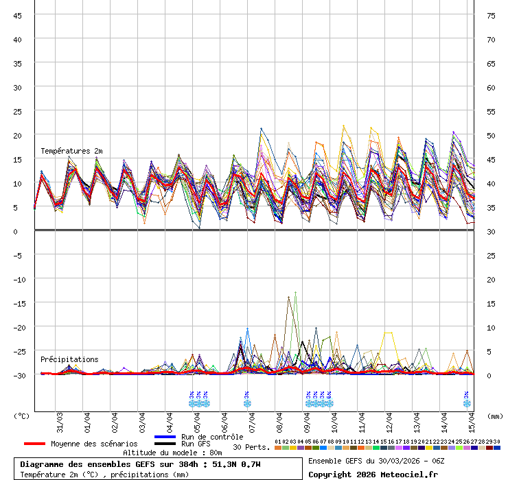
From this weekend we could be looking at ice days or temperatures into double figures.

I would say the pendulum has slightly swung to the mild end, looking at the ensemble as a whole.


Edit: actually, more than just slightly. Compare the 0Z set:
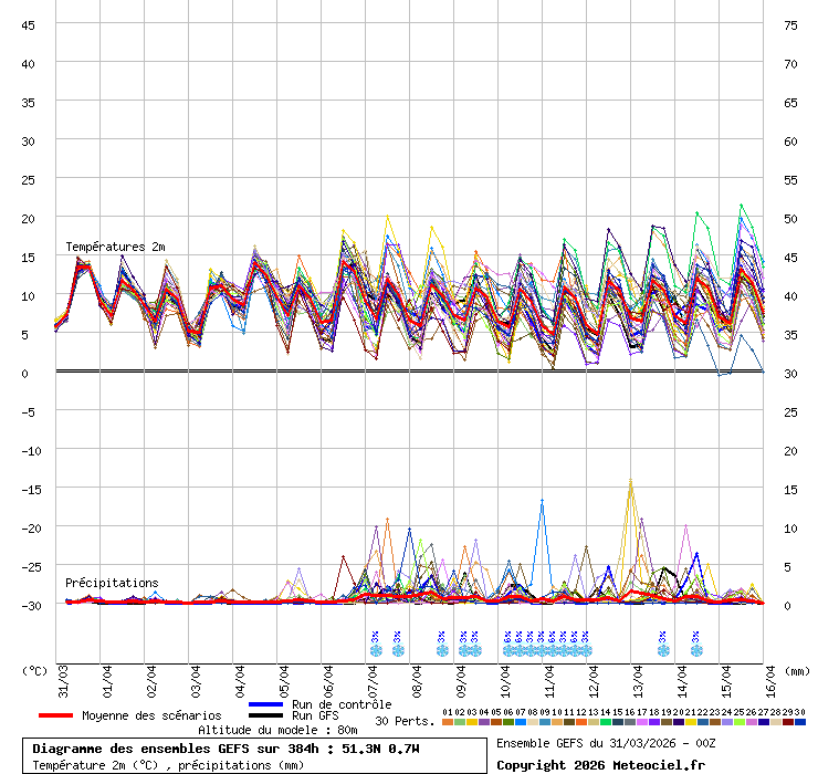
 

More sign of the Atlantic winning out on the 6Z.


Yateley, NE Hampshire, 73m asl

"But who wants to be foretold the weather? It is bad enough when it comes, without our having the misery of knowing about it beforehand." — Jerome K. Jerome

hobensotwo
07 February 2021 12:33:46

06z for London shows the Op run is a colder outlier:

Originally Posted by: tallyho_83 

That is a massive mess of scatter and uncertainty, after the 11th.

Good luck spotting a treat out of that lot.

Rob K
07 February 2021 12:38:48
Lots of people slating the forecasters and auto output but trying to distil that mess into a numerical forecast for the weekend is impossible.

Temperature... somewhere between -2C and 12C... wind direction... souheasterly, southwesterly, calm.... conditions.... snow, rain, fog, dry... literally could be just about anything.


Yateley, NE Hampshire, 73m asl

"But who wants to be foretold the weather? It is bad enough when it comes, without our having the misery of knowing about it beforehand." — Jerome K. Jerome

NDunwell
07 February 2021 12:42:06

Guys, seriously stop posting charts at 342 and 350 hrs, it is pointless.

Originally Posted by: warrenb 

I suggest this is the wrong thread for you then. The clue is in the name by the way if you haven't worked that out.


Nick

Ruislip (2 miles from the Northolt recording station)

The Beast from the East
07 February 2021 12:42:06

And here is the full set of 2m temps for my location. Absolutely no idea!

From this weekend we could be looking at ice days or temperatures into double figures.

I would say the pendulum has slightly swung to the mild end, looking at the ensemble as a whole.


Edit: actually, more than just slightly. Compare the 0Z set:


More sign of the Atlantic winning out on the 6Z.

Originally Posted by: Rob K 

UKMO this morning was not good (for cold). But perhaps we will be yearning for something less cold in a few days time anyway. 


Purley, Surrey, 70m ASL

"We have some alternative facts for you"

Kelly-Ann Conway - former special adviser to the President

Rob K
07 February 2021 12:45:30

Just to remind people not to put too much faith in model output, I had a look for the GFSP but it still shows Thursday's 12Z run. This was what it was meant to be like this morning!


Yateley, NE Hampshire, 73m asl

"But who wants to be foretold the weather? It is bad enough when it comes, without our having the misery of knowing about it beforehand." — Jerome K. Jerome

tallyho_83
07 February 2021 12:51:51

Just to remind people not to put too much faith in model output, I had a look for the GFSP but it still shows Thursday's 12Z run. This was what it was meant to be like this morning!


Originally Posted by: Rob K 

I wish the Para was working properly.


Home Location - Vixen Tor Close, Okehampton, Devon (221m ASL)

---------------------------------------

Sean Moon

Magical Moon

www.magical-moon.com

Heavy Weather 2013
07 February 2021 12:56:48

Just to remind people not to put too much faith in model output, I had a look for the GFSP but it still shows Thursday's 12Z run. This was what it was meant to be like this morning!


Originally Posted by: Rob K 

To be honest, based on today, any new easterly can stuff itself. 


Mark

Beckton, E London

Less than 500m from the end of London City Airport runway.

Remove ads from site