The Weather Outlook

Remove ads from site

Rob K
04 February 2021 16:21:56
GEFS median 850s are 2C higher by just 90 hours on this run in London. Small margins but it is swinging the wrong way for the SE at the moment.
Yateley, NE Hampshire, 73m asl

"But who wants to be foretold the weather? It is bad enough when it comes, without our having the misery of knowing about it beforehand." — Jerome K. Jerome

ballamar
04 February 2021 16:24:17
Cannot understand the pessimism on here - I am looking at Sunday now and the radar. The picture looks like a snowy one for at least 3 days and after that it may or may not breakdown. Unlikely to know due to the impact of what happens before that. Sliders under a renewed Scandi high look distinctly possible
Whether Idle
04 February 2021 16:24:27

Jeez. There are a few bed wetters in here this evening.

The rain line will be where the yellow colours start.

Originally Posted by: Gusty 

You wear incontinence pants, which is cheating!


Dover, 5m asl. Half a mile from the south coast.
Gooner
04 February 2021 16:24:27

Para 42 hours of snow lol


Remember anything after T120 is really Just For Fun


Marcus

Banbury

North Oxfordshire

378 feet A S L


warrenb
04 February 2021 16:24:54

GEFS median 850s are 2C higher by just 90 hours on this run in London. Small margins but it is swinging the wrong way for the SE at the moment.

Originally Posted by: Rob K 

Oh dear 


GEM, GFSP,ICON and UKMO are all fine, and all the comments are about the one model that we all know likes to flip out every now and again (6z yesterday where the Oh Dears came out again).


stophe
04 February 2021 16:25:56

GFS PARA on Wednesday.

Gusty
04 February 2021 16:26:17

Cannot understand the pessimism on here - I am looking at Sunday now and the radar. The picture looks like a snowy one for at least 3 days and after that it may or may not breakdown. Unlikely to know due to the impact of what happens before that. Sliders under a renewed Scandi high look distinctly possible

Originally Posted by: ballamar 

The only pessimism should be coming from the folk of SE Kent who really need to see that 0c 850Hpa isotherm pushed a little further south as its delaying (on this run) the onset of something potentially very interesting on Sunday.


Steve - Folkestone, Kent

Current conditions from my Davis Vantage Vue

https://www.wunderground.com/dashboard/pws/IFOLKE11 

Join Kent Weather on Facebook.

https://www.facebook.com/stevewall69/ 


Gooner
04 February 2021 16:26:30

Para 174 looks very good , I am betting the OP is on the high side 


Remember anything after T120 is really Just For Fun


Marcus

Banbury

North Oxfordshire

378 feet A S L


Chiltern Blizzard
04 February 2021 16:26:41

What is it with 850Hpa's you lot ? 

Check out your 925's and you'll see they are als0 -4 or -5

Check out your dewpoints and you'll see they are sub zero.

Originally Posted by: Gusty 

Just about to post something similar... 850s are not the be and end all... we don’t live at 5,000 feet.  The same gfs that’s not showing unremarkable 850s across parts of the south is also showing ice days.


Rendlesham, Suffolk 20m asl
Justin W
04 February 2021 16:27:24

I'm going to go completely against character and say that the GFS OP is going to be way off while the UKMet and GFSP will be closer to the mark. 


Yo yo yo. 148-3 to the 3 to the 6 to the 9, representing the ABQ, what up, biatch?
squish
04 February 2021 16:27:26
ukmo and icon look good to me
D.E.W on Dartmoor. 300m asl
JRobinson
04 February 2021 16:28:04

Para 174 looks very good , I am betting the OP is on the high side 

Originally Posted by: Gooner 


Me too.

To me the GEFS members look better. 

Rob K
04 February 2021 16:28:17

Arpege has the air generally cold enough although a few small milder pockets in there


Still quite a big change from the -10s we were looking at even in the south. Definitely some dilution going on in the models this afternoon.


Yateley, NE Hampshire, 73m asl

"But who wants to be foretold the weather? It is bad enough when it comes, without our having the misery of knowing about it beforehand." — Jerome K. Jerome

nsrobins
04 February 2021 16:28:39
It’s fine margins on GFS and less so ICON but only in the far S and SE.

UKM, GFSP and GEM on track for all by clearing the low further south.

I suspect it’s typical GFS and it’ll be back 200 miles further south later.

Good this in it?


Neil

Fareham, Hampshire 28m ASL (near estuary)

Stormchaser, Member TORRO

Heavy Weather 2013
04 February 2021 16:29:21

GEFS median 850s are 2C higher by just 90 hours on this run in London. Small margins but it is swinging the wrong way for the SE at the moment.

Originally Posted by: Rob K 

This is a worrying trend indeed. I didn't like the uppers on the 6z GFS either. ICON seems to have followed it. Im only nervous because its a trend over two runs.

I don't need this stress lol


Mark

Beckton, E London

Less than 500m from the end of London City Airport runway.

Rob K
04 February 2021 16:29:43
Rain reaches Scotland from the south by Saturday on the GFS.... get in the bin
Yateley, NE Hampshire, 73m asl

"But who wants to be foretold the weather? It is bad enough when it comes, without our having the misery of knowing about it beforehand." — Jerome K. Jerome

Ally Pally Snowman
04 February 2021 16:30:13

GFS PARA on Wednesday.

Originally Posted by: stophe 

Very similar to the UKMO. 


Bishop's Stortford 85m ASL.
warrenb
04 February 2021 16:31:08


This is a worrying trend indeed. I didn't like the uppers on the 6z GFS either. ICON seems to have followed it. Im only nervous because its a trend over two runs.

I don't need this stress lol

Originally Posted by: Heavy Weather 2013 

Oh dear 


doctormog
04 February 2021 16:31:08
This is a new one for me. At midday on Sunday the mildest 12z GFS ensemble member for here is -10.2ºC. Impressive.
Whether Idle
04 February 2021 16:32:09

It’s fine margins on GFS and less so ICON but only in the far S and SE.
UKM, GFSP and GEM on track for all by clearing the low further south.
I suspect it’s typical GFS and it’ll be back 200 miles further south later.
Good this in it?

Originally Posted by: nsrobins 

GEM has been stoic as has UMKO. GFS has wibble wobbled.

I genuinely think the situation (as regards Sunday) for those of us on the coast down South will continue to be nail biting right up to Saturday - when we should know our fate.


Dover, 5m asl. Half a mile from the south coast.
Rob K
04 February 2021 16:33:05

This is a new one for me. At midday on Sunday the mildest 12z GFS ensemble member for here is -10.2ºC. Impressive.

Originally Posted by: doctormog 


Yes looking at the mean the GEFS has the core of the cold slightly further north than previously so you are right in the coldest spot.


Which is why the stress levels down south are starting to soar 


Yateley, NE Hampshire, 73m asl

"But who wants to be foretold the weather? It is bad enough when it comes, without our having the misery of knowing about it beforehand." — Jerome K. Jerome

CField
04 February 2021 16:34:00

surely they could be the pockets of very heavy snow.

The great snowstorm of Jan 82 was predicted to turn to rain in the south.The rain got as far as Southampton. I was looking out the school window diligently waiting for the turn but the snow really popped up and never turned to rain.

Question is I'm living in Essex at present and have a house in Kent.Is it worth going down just to put the heating on to prevent burst pipes or is it going to be just -1 -2 stuff at worst under cloud cover, cant see any real problems unless skies really clear and wind dies down for a long period which I cant see happening.

Arpege has the air generally cold enough although a few small milder pockets in there
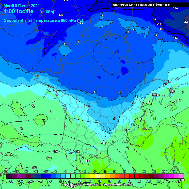
 

Still quite a big change from the -10s we were looking at even in the south. Definitely some dilution going on in the models this afternoon.


Originally Posted by: Rob K 


Favourite snowstorm

Famous channel low

Dec 31st 1978

Hastings East Sussex

Foot of level snow severe drifting

Next day max temp -4 degrees Celsius

idj20
04 February 2021 16:35:54

Rain reaches Scotland from the south by Saturday on the GFS.... get in the bin

Originally Posted by: Rob K 


While by that time it would be feeling positively spring-like under a drying south west airflow. I'd take that run over a wet and windy breakdown, I'd be sick and tired of feeling/being cold and damp by then anyway.


Home location: Folkestone Harbour.
Rob K
04 February 2021 16:35:54

Calling Brian, I think there is a problem with the thickness calculations on these ICON charts as I am fairly sure the 500dam line isn't approaching Aberdeen... much as the doc might wish it was!


Yateley, NE Hampshire, 73m asl

"But who wants to be foretold the weather? It is bad enough when it comes, without our having the misery of knowing about it beforehand." — Jerome K. Jerome

Whiteout
04 February 2021 16:41:54


You are right to be jittery.  Its all knife edge stuff down here Neil, and further northward corrections and it will be a cold rain fest for southcoasters Sunday.  I will hope for a better picture on the GFS 12zs tomorrow.

My new favourite model Gem keeps the low where we need it for success on Sunday. UKMO also favourable.

Originally Posted by: Whether Idle 

What are you two on about, you can see on the ens that this will be an outlier and the UKMO is stunning, not favourable.


Home/Work - Dartmoor

240m/785 ft asl

Remove ads from site