Remove ads from site
Looks llike the cold(er) snap is over before it even gets started!
Originally Posted by: briggsy6
how do you work that one out??
The next week loooks settled and generally a bit colder than average - not really a winter’s blast (and never was modelled as such) just chilly and anticyclonic.
The much anticipated colder weather is forecast from midmonth and is supported by a range of model output.
Current conditions (personal WS)
How can something possibly finish before it even starts lol
5c tomorrow 5c Thursday 3c Friday...……..chillier enough me thinks
Marcus
Banbury
North Oxfordshire
378 feet A S L
Ye gods.
(I guess this is the SSW-induced equivalent of those 920hPa lows that the GEFS loves to cook up during zonal periods!)
"But who wants to be foretold the weather? It is bad enough when it comes, without our having the misery of knowing about it beforehand." — Jerome K. Jerome
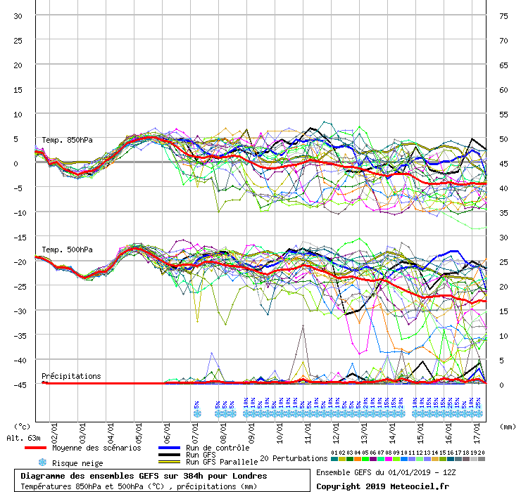
Indeed the mean is now down to -5C for London by the end of the run. The GFSP mentioned above was actually one of the milder options.
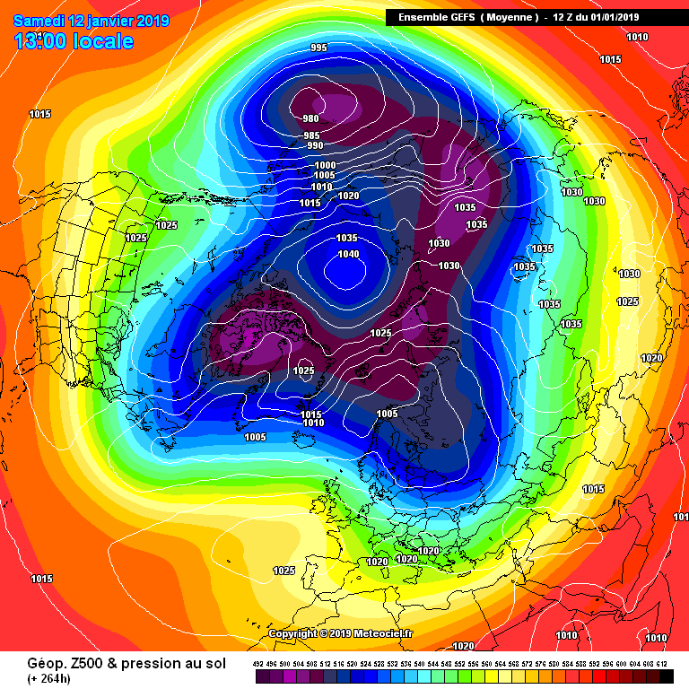
Yes Darren, at 264hrs the MEAN chart has a 1040mb high over the pole! Rare sight there.
Originally Posted by: Rob K
The Para must be the 6z as the 12z gets cold late on -8 850s for London
Originally Posted by: Ally Pally Snowman
Yes, when I posted that chart the parallel run hadn't even finished coming out so I did wonder!
I think it must be yesterday's 12z Para as the 0z, 6z and 12z are all cold .
ECM is a decent run ending in
http://www.wetterzentrale.de/maps/ECMOPEU12_240_1.png
Originally Posted by: Gooner
That really is a stunning chart frigid 850s incoming from the NE.
Looks promising! UKMO looks less so.
http://old.wetterzentrale.de/pics/Recm2402.gif
A lot can change from day 6 (144hr) to day 10 (240hr) and it is hard to say how it would on the UKMO 12z run. However if the ECM stopped at day 6 people may not be that interested either.
Originally Posted by: doctormog
True, although ECM is keeping the high ridging to the north even by T144 while UKMO has already started to sink it south. A lot will chop and change over the coming days I think!
I said just before Christmas that anyone frustrated with the charts ought to wait until New Year when the eye candy should start appearing, and so it has...
Slow trends gathering pace, it’s taking its time. As always it’s not about looking at runs in isolation or pretending the next run will be ‘the decider’.
By the pricking of my thumbsSomething wicked this way comes ...
http://www.wxmaps.org/pix/temp4 week 2
Chichester 12m asl
Originally Posted by: DEW
If we’re to hit the jackpot like last year we need to mainline a proper frigid continental airmass.
Ive doubt it will reappear on the 6z run.
Weather station:
https://www.wunderground.com/personal-weather-station/dashboard?ID=IWIRRAL24#history
And then the cold FI signal is gone againIve doubt it will reappear on the 6z run.
Originally Posted by: Russwirral
on the op run but look at the ENS trend
Originally Posted by: ballamar
The ens from 12z arent much more inspiring tbh. A little bit of scatter below the seasonal norm.. but majority runs above norm until at least 11th Jan.
Ive gotta.say we are in the midst of probably some of the worst model runs ive seen in years... maybe even top 5 worst ever period.
Ecm seemed to look ok towards the end.. but nothing seems to land on the UK... cold at best gets just near the UK.
Not a moan, ive enjoyed the milder weather... but its bonkers how bad its been so far.
Edit.... even less scatter on the 18z ens.... above average upper temps for the forseable.