nsrobins
25 February 2020 00:08:52

Originally Posted by: DPower 


Well it looks to me as if this forum is no different to the other one. I read on the other forum a few days back a poster was not sure of the forecast to make for the coming two or three days ahead and was unsure what to tell family and friends. I mean seriously do posters on here and the other forum really think they are better than the professionals. Its the same with the posters spouting out teleconnections this and teleconnects that yet they really haven't a scooby do. 


The Met office forecast for this winter season was bang on the ball yet in the Autumn many (including myself ) questioned their bullishness of a mild to very mild and unsettled winter giving a 50 to 60 percentile probability. Not often you see them that bullish about any given forecast yet i did not see one single long range forecast saying we would see a very positive AO this winter. 


One so called or self professed professional on the American forum was claiming success yet he fore cast a neutral AO during the Winter months. Sorry pal that is a big bust in my book. My point of this post being yes these forums can be a form of  great entertainment but at the end of the day we are only amateurs. Lets not kid ourselves.


We might be (mostly) amateurs, but some are more amateur than others.


😉


Neil
Fareham, Hampshire 28m ASL (near estuary)
Stormchaser, Member TORRO
Brian Gaze
25 February 2020 07:08:49

Could be a white Thursday morning in the Chilterns. The model output is now quite consistent and even Arpege which is usually quite realistic shows the likelihood of snow. 


Brian Gaze
Berkhamsted
TWO Buzz - get the latest news and views 
"I'm not socialist, I know that. I don't believe in sharing my money." - Gary Numan
DEW
  • DEW
  • Advanced Member
25 February 2020 07:23:30

The pattern of Atlantic depressions running across the UK does not let up for the foreseeable future - even the HP seen in FI in previous runs has gone. Enough cold PM air being dragged in after each LP to offer snow on hils and perhaps transiently at low levels. Watch out for depressions on the following though no doubt timing will vary: Thu 27th 990mb Channel; Sun 1st 960mb Western Isles; Thu 5th 970 mb S Scotland; Sun 7th 990 mb SW approaches; Tue 10th 990 mb Bristol Channel; Thu 12th 965 mb Fair Isle. 


ECM similar but Thu 27th a weaker feature and Sun 1st further north


Ensembles show mean temp a degree or so below seasonal norm (brief mildness on 29th), minimal chance of snow on the South Coast, pretty well a certainty in Inverness; rain on and off throughout, heaviest in the south.


War does not determine who is right, only who is left - Bertrand Russell

Chichester 12m asl
Rob K
25 February 2020 08:02:38
Phone app now has a snowflake symbol for Thursday here but looking at the model output I think I’m a bit too far south to see anything. Maybe some sleet to spoil the snow-free winter at the last gasp!
Yateley, NE Hampshire, 73m asl
"But who wants to be foretold the weather? It is bad enough when it comes, without our having the misery of knowing about it beforehand." — Jerome K. Jerome
idj20
25 February 2020 08:33:48

Just hope ICON is overcooking the wind speeds associated with a small but active runner low for Saturday morning as other models are showing more toned down versions associated with a passing cold front.

This is the gust forecast by ICON . . . 


Should this actually turn out to verify nearer to the moment then I think this would be of more concern than a few minutes of transient snow. 


Folkestone Harbour. 
fairweather
25 February 2020 11:20:32

Originally Posted by: DPower 


Well it looks to me as if this forum is no different to the other one. I read on the other forum a few days back a poster was not sure of the forecast to make for the coming two or three days ahead and was unsure what to tell family and friends. I mean seriously do posters on here and the other forum really think they are better than the professionals. Its the same with the posters spouting out teleconnections this and teleconnects that yet they really haven't a scooby do. 


The Met office forecast for this winter season was bang on the ball yet in the Autumn many (including myself ) questioned their bullishness of a mild to very mild and unsettled winter giving a 50 to 60 percentile probability. Not often you see them that bullish about any given forecast yet i did not see one single long range forecast saying we would see a very positive AO this winter. 


One so called or self professed professional on the American forum was claiming success yet he fore cast a neutral AO during the Winter months. Sorry pal that is a big bust in my book. My point of this post being yes these forums can be a form of  great entertainment but at the end of the day we are only amateurs. Lets not kid ourselves.


This is of course true. There are a lot of self proclaimed experts out there hence the outlandish "Express" type headlines. Joe ******i, (asterisks not inserted by me !!) Corbyn's brother, Madden etc. They obviously don't have the resources or collective brain and computer power of the National forecasting agencies who will always be more reliable. However they don't tend to speculate past a week ahead (probably because they know it's mainly rubbish) whereas we can if we want to. And we have fun trying to second guess them and are possibly quite good at a local level because they don't have the time to spend on IMBY stuff.


S.Essex, 42m ASL
Rob K
25 February 2020 11:45:37

Arpege has pushed Thursday's snow risk way to the north compared to previous runs. The low now tracks across to East Anglia with the 0C isotherm around Suffolk. Other models have it a bit further south.


Yateley, NE Hampshire, 73m asl
"But who wants to be foretold the weather? It is bad enough when it comes, without our having the misery of knowing about it beforehand." — Jerome K. Jerome
idj20
25 February 2020 12:22:35

Originally Posted by: Rob K 


Arpege has pushed Thursday's snow risk way to the north compared to previous runs. The low now tracks across to East Anglia with the 0C isotherm around Suffolk. Other models have it a bit further south.


And in turn would bring more unwanted strong westerly winds to Kent. 


Folkestone Harbour. 
Gooner
25 February 2020 16:24:28


Id settle for that IMBY


Remember anything after T120 is really Just For Fun


Marcus
Banbury
North Oxfordshire
378 feet A S L


Ally Pally Snowman
25 February 2020 16:30:45

Originally Posted by: Gooner 


Id settle for that IMBY


Finally maybe just maybe winter might just turn up. Fingers crossed Gooner!


Bishop's Stortford 85m ASL.
idj20
25 February 2020 16:37:17

Yuk with what will still be cold rain crap here at the South coast of England, but looking further ahead still, that's better with the FI part of the 12z GFS output, I would bank that. Doubtless it'll be gone in the 18z but it has cheered me up on this dull damp cold late afternoon. 


Folkestone Harbour. 
doctormog
25 February 2020 16:55:25
Lots more sunshine to come here if the westerlies continue. We are in triple figures in terms of sunshine hours for the month now and if we cannot get snow that will do nicely.
DEW
  • DEW
  • Advanced Member
26 February 2020 07:24:25

The overall picture http://www.wxmaps.org/pix/temp4 is notable for the continuing above average temps in central/eastern Europe and in the associated pptn chart, above average rainfall in W Europe incl UK (gets a little better in week 2).


GFS continues the string of LPs off the Atlantic - will just mention 955mb N Scotland Sun 1st and 980 mb E Anglia Sun 8th but there are others. This model has reinstated the ridge of HP Spain - Scandi now shown on Thu 12th but its existence is in doubt as it has been appearing in and disappearing from subsequent charts, and the date of its establishment gets delayed ... and delayed.


ECM is similar but LP on Sun 8th weaker(and a day earlier) - and a much deeper Atlantic depression off Labrador on that date.


ENS as yesterday; bump of mild and wet on 29th Feb, thereafter cool and wet, the rain especially persistent in the south - and with a remarkable leap in temps 11 Mar shown on the control run but only one or two runs.


War does not determine who is right, only who is left - Bertrand Russell

Chichester 12m asl
Gooner
26 February 2020 09:47:37


Well GFS 6z has shunted the snow further North ……….not good for MBY


Remember anything after T120 is really Just For Fun


Marcus
Banbury
North Oxfordshire
378 feet A S L


Gooner
26 February 2020 09:54:28

Ignore that , wrong day 


Tramadol kicking in 


Remember anything after T120 is really Just For Fun


Marcus
Banbury
North Oxfordshire
378 feet A S L


johncs2016
26 February 2020 10:07:47

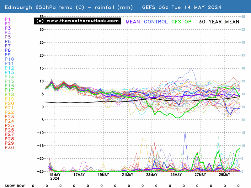
850hPa temperatures, precipitation and the snow row


I'm not sure what others think of the above chart but since my last post in this thread, it looks as though the wet weather at the very end of this month in this part of the world has been delayed by a day or so (that is shown not to be happening until 29 February). Beyond that, there are still some rainfall spikes around but it doesn't look to me as though our outlook is unsettled as it was looking the last time I posted here, especially once we get past 2/3 March.


This shows that the outlook for this part of the world might not end up being as unsettled after all, as what it would appear to be going by others are saying. What hasn't changed though is that with the exception of a brief warmer spell at the very end of the month going into March, the outlook for here is still quite cold until we get to around the middle of the second week of March.


The GFS operational has it warming up quite a lot here around 10 March and although that is only really an outlier, the general trend does appear to be a bit warmer as we approach the middle of the month although for now, this is still only in the unreliable time frame.


The north of Edinburgh, usually always missing out on snow events which occur not just within the rest of Scotland or the UK, but also within the rest of Edinburgh.
tallyho_83
26 February 2020 10:09:42

Originally Posted by: Gooner 


Well GFS 6z has shunted the snow further North ……….not good for MBY


The above Marcus is a different system and is for Friday? The system tomorrow will still produce snow INBY.


Home Location - Kellands Lane, Okehampton, Devon (200m ASL)
---------------------------------------
Sean Moon
Magical Moon
www.magical-moon.com


tallyho_83
26 February 2020 10:11:25

Originally Posted by: Gooner 


Ignore that , wrong day 


Tramadol kicking in 


This is more like it for you!? - But could be heavy wet snow with little or no accumulations. Again nice to be reminded where the M4 is - haven't seen it at all this winter! ha.


Home Location - Kellands Lane, Okehampton, Devon (200m ASL)
---------------------------------------
Sean Moon
Magical Moon
www.magical-moon.com


warrenb
26 February 2020 10:19:58
GFS 6z looking very stormy.
idj20
26 February 2020 10:25:41

Originally Posted by: warrenb 

GFS 6z looking very stormy.


Sadly, it seems that the ICON chart I showed the other day is being on the money.

Next week is also looking changeable where I'm having to wait until the second week of March before I can think about hoping for more in the way of settled conditions - probably only for that to be snatched away from us.


Folkestone Harbour. 
Users browsing this topic

Ads