Russwirral
03 October 2019 09:09:13

Originally Posted by: White Meadows 


your link didn’t work for me, but I think you mean this one: 


https://www.natice.noaa.gov/pub/ims/ims_gif/DATA/cursnow_asiaeurope.gif


Looks fairly normal to me?


I think the understatement is the start for Scandinavia... .thats usually the last place on that latitude to get snow cover, usually well into November.


Rob K
03 October 2019 11:18:52

Originally Posted by: David M Porter 


Not sure that was the case, despite the unsually warm spell during mid-late February.


I assumed he meant warmest February day ever, which we did of course.


Feb this year was an interesting month. Very heavy wet snow right at the start (10-12cm here) which led to trees coming down and blocking several roads in this area, then three weeks later we were basking in 20C+ warmth.


Yateley, NE Hampshire, 73m asl
"But who wants to be foretold the weather? It is bad enough when it comes, without our having the misery of knowing about it beforehand." — Jerome K. Jerome
tallyho_83
03 October 2019 11:26:37

Originally Posted by: White Meadows 


your link didn’t work for me, but I think you mean this one: 


https://www.natice.noaa.gov/pub/ims/ims_gif/DATA/cursnow_asiaeurope.gif


Looks fairly normal to me?


not working?? How come? What do you mean? should be an image?


Look how much snow cover there is over many parts of Siberia and Northern Russia and even Mongolia already has snow cover too as well as parts of Scandinavia - and remember the early snowstorm in the Northern states of the USA like Montana on 30th Sept and into Canada ! I would say this is pretty impressive given October is only a few days old.


Home Location - Kellands Lane, Okehampton, Devon (200m ASL)
---------------------------------------
Sean Moon
Magical Moon
www.magical-moon.com


ballamar
03 October 2019 11:28:03
Models do appear quite blocked in later stages and not in their usual spots. Does it mean anything no, but could we get a late October cold snap potentially yes
Steve Murr
03 October 2019 13:00:57

Originally Posted by: ballamar 

Models do appear quite blocked in later stages and not in their usual spots. Does it mean anything no, but could we get a late October cold snap potentially yes


The current run ( from April 26 ) to date of the -NAO has been caused by a strong final warming in the stratosphere in early April & the residual warm in the troposphere all summer due to ice loss upward forcing-


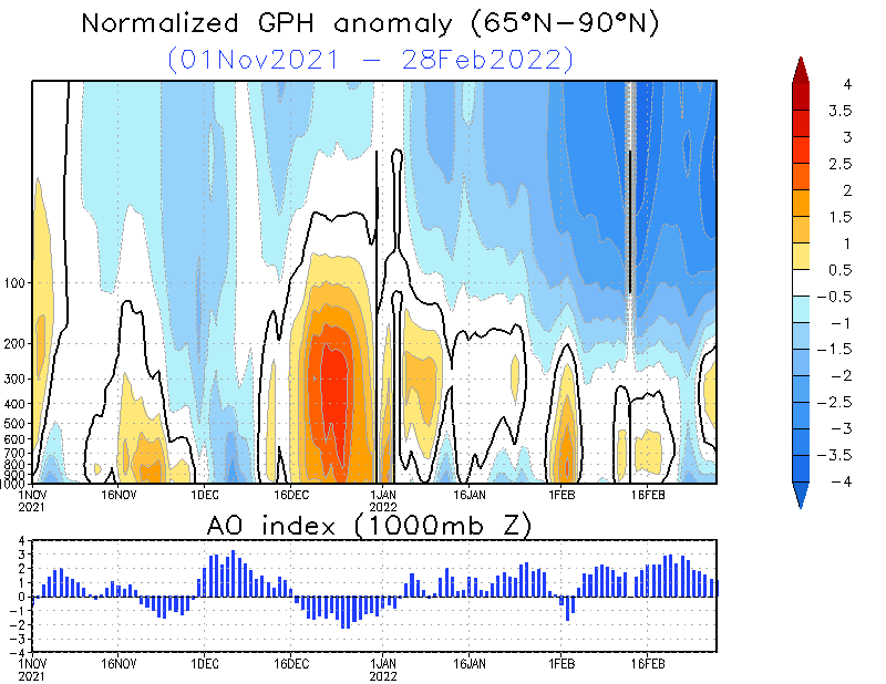
The current normalized polar height anomaly captures this well.


This winter ( which I will add into the form of a thread at some point ) will hinge around how long the troposphere & its residual warmth can stay disconnected to the downwelling of the colder stratosphere as well as staying in the blocked stage without attack from the tropospheric influencers - The main 2 being


  • A super Nino which strongly impact the pacific jet ( luckily a SuperNino )

  • High magnitude of sunspot activity


Luckily both of the aforementioned variables are well placed this year.


Current persistence of blocking over the pole is expected to last all of October.


** Key dates & phases are mid November when stratospheric downwelling becomes harder to fend off & upward heat flux needs to counter balance the downwelling. 


Historically the 'norm' of the arctic is there is minimal counter balance until a SSW downwells warmth from the strat however this year our starting position is good in the troposhere ( but only based on the summer persistence )


The real driver if there is one is Arctic climate change which is injecting some disproportionate warmth into the pole through reduced sea ice - as well as the SAI that should support a further positive feedback loop.


With all that said & done the status quo then should remains for a good few weeks with Northern blocking featuring & critically further injections of abnormal warmth into the pole especially towards western Greenland. - These events & the SAI ( as well as the sun activity ) are the variables that are presenting themselves this year as the 'possible' counter balances. The best example of which is also fits perfectly into the sunspot cycle is 2009 > 10


Which saw a perfect counter balance in November...


So this is the date to look for ( Mid Nov ) in terms what the polar profile looks like -


Many thanks 


Steve

Maunder Minimum
03 October 2019 13:30:22

Good to see your contribution Steve and an interesting one as always. We are due for something and given the lack of solar activity and other factors, who knows? Maybe 2019-20 will be a winter to remember - we can always hope so.


New world order coming.
Solar Cycles
03 October 2019 15:29:37
The anomalous warmth around the NW Canadian Pacific sector doesn’t bode well for a colder than average winter for these shores, it’s been a bogeyman in recent years. I still think it’s too early in the season for compiling analogues and looking at specific details on how the NAO has behaved over recent months.....

A lot of factors to take on board but until we get into next month it’s even more speculative than usual really.
tallyho_83
04 October 2019 00:04:08

Can anyone get this page to load on this long range severe-weather.eu site:


Anyone getting nothing when they click read more?


http://www.severe-weather.eu/long-range-2/winter-2019-2020-early-look/


Home Location - Kellands Lane, Okehampton, Devon (200m ASL)
---------------------------------------
Sean Moon
Magical Moon
www.magical-moon.com


some faraway beach
04 October 2019 09:12:26
"SA!"?
2 miles west of Taunton, 32 m asl, where "milder air moving in from the west" becomes SNOWMAGEDDON.
Well, two or three times a decade it does, anyway.
tallyho_83
04 October 2019 09:35:00

Originally Posted by: some faraway beach 

"SA!"?


Home Location - Kellands Lane, Okehampton, Devon (200m ASL)
---------------------------------------
Sean Moon
Magical Moon
www.magical-moon.com


Maunder Minimum
04 October 2019 09:38:55

Originally Posted by: tallyho_83 


Can anyone get this page to load on this long range severe-weather.eu site:


Anyone getting nothing when they click read more?


http://www.severe-weather.eu/long-range-2/winter-2019-2020-early-look/


Makes grim reading for winter weather lovers in any case.


New world order coming.
Rob K
04 October 2019 10:14:54

Originally Posted by: Maunder Minimum 


Makes grim reading for winter weather lovers in any case.


Yep. Positive height anomalies over Europe, negative over Greenland, couldn't be worse really. But we all know those forecasts are essentially useless!


Yateley, NE Hampshire, 73m asl
"But who wants to be foretold the weather? It is bad enough when it comes, without our having the misery of knowing about it beforehand." — Jerome K. Jerome
Russwirral
04 October 2019 10:30:57

Originally Posted by: Maunder Minimum 


Makes grim reading for winter weather lovers in any case.


Meh, if theyre presenting the worst case for winter lovers- then (as a cold lover) we can only hope for better outcome


Given these LRF have never really delivered, Im quite confident of blizzards!!


tallyho_83
04 October 2019 10:51:01

Originally Posted by: Rob K 


Yep. Positive height anomalies over Europe, negative over Greenland, couldn't be worse really. But we all know those forecasts are essentially useless!


As always it's a guessing game really!!


But can anyone else see the actual forecast when they click on read more??


Home Location - Kellands Lane, Okehampton, Devon (200m ASL)
---------------------------------------
Sean Moon
Magical Moon
www.magical-moon.com


some faraway beach
04 October 2019 15:11:55

From that link:


Knowing all this, we can understand why the old saying “if we can’t even forecast 3 days ahead, why do we waste time forecasting 3 months ahead?” is kinda false. Because long range forecasts are something completely different than the weather forecast we watch on TV every night. One is forecasting the temperature on your backyard for every hour, for the next 2 or 3 days, while the other one forecasts if air pressure over the Atlantic ocean will be higher or lower in January and February, compared to the 30-year average. It is kinda like comparing oranges to bananas. Both are fruits, but they grow on completely different trees and taste differently. 


This is silly. This model output he's describing is just an ensemble of the daily output run forward until the end of February. It's precisely because we can't forecast accurately 3 days ahead that running them forward for a further 3 months is just a waste of electricity.


We see the spaghetti produced by the GFS ensemble every day by the day-15 mark. That doesn't magically become precise or accurate just because you carry on running it until day 90.


I think that of all the long-range forecasting tools, seasonal models output is out on its own as a pointless stab in the dark.


2 miles west of Taunton, 32 m asl, where "milder air moving in from the west" becomes SNOWMAGEDDON.
Well, two or three times a decade it does, anyway.
tallyho_83
04 October 2019 23:27:13

Have to admit that this is impressive amount of snow cover for Russia and Scandinavia and we're not even a week into October yet!


Many central parts of Norway are covered in snow and seems like the snow is knocking on the doorstep of Saint Petersburg and even Helsinki.


Of course it may melt or retreat but still very impressive amounts of snow cover in Russia & Scandinavia for so early in the season!


Home Location - Kellands Lane, Okehampton, Devon (200m ASL)
---------------------------------------
Sean Moon
Magical Moon
www.magical-moon.com


Sasa
  • Sasa
  • Advanced Member
07 October 2019 16:29:53

It is interesting to see some early wintriness in Moscow @7th October. i seem to recall quite well that in the 80s this was a regular feature and the winters that followed produced abundant snowfall in Europe and the UK.


I do not think we had anything like this in the last 10 - 15 years and I wonder if there is any correlation between the two which could point to a snowier winter 2019-20?


Kingston Upon Thames
tierradelfuego
07 October 2019 18:50:35

Talking to one of the project team in Denver this afternoon and seems like they are having their first winter blast on Thursday. 77F today down to 27F and snow in 3 days time, quite a temp drop there.


Bucklebury
West Berkshire Downs AONB
135m ASL
Saint Snow
07 October 2019 20:36:01

Originally Posted by: tierradelfuego 


Talking to one of the project team in Denver this afternoon and seems like they are having their first winter blast on Thursday. 77F today down to 27F and snow in 3 days time, quite a temp drop there.


North America has the best weather on the planet - so much variability between and within seasons.


Martin
Home: St Helens (26m asl) Work: Manchester (75m asl)
A TWO addict since 14/12/01
"How can wealth persuade poverty to use its political freedom to keep wealth in power? Here lies the whole art of Conservative politics."
Aneurin Bevan
Hungry Tiger
08 October 2019 14:44:17


UserPostedImage  upload 


Gavin S. FRmetS.
TWO Moderator.
Contact the TWO team - [email protected]
South Cambridgeshire. 93 metres or 302.25 feet ASL.


Users browsing this topic

    Ads