Joe Bloggs
26 November 2017 10:01:39
As Doc has already said, this is very cold for late November.

http://www.wetterzentrale.de/maps/GFSOPEU06_63_2.png 


Manchester City Centre, 31m ASL

polarwind
26 November 2017 10:02:28

Originally Posted by: Joe Bloggs 


Just to provide an example for my previous point - 


Look at the T+240 ECM chart http://www.wetterzentrale.de/maps/ECMOPEU00_240_2.png


It has the potential to give us some very cold weather, but look at all that balmy air heading towards Western Greenland. Warm air being bottled up at northern latitudes is partly caused by unusual weather patterns in the Atlantic, which conversely are the same ones which give us a good shot at colder weather. 


Thats not to say the Arctic hasn’t warmed because of climate change, of course it has, but the current Atlantic blocking patterns will also be a factor. 


Indeed. But those blocking patterns will slow the North Atlantic Drift and reduce the energy reaching the Arctic and leading to increased ice cover. What impact would more Arctic ice have on the depth of cold reaching GB on a Northerly? A no brainer.


"The professional standards of science must impose a framework of discipline and at the same time encourage rebellion against it". – Michael Polyani (1962)
"If climate science is sound and accurate, then it should be able to respond effectively to all the points raised…." - Grandad
"The whole problem with the world is that fools and fanatics are always so certain of themselves, and wiser people so full of doubts". - Bertrand Russell
"Science is the belief in the ignorance of the experts" – Richard Feynman
"A consensus means that everyone agrees to say collectively what no one believes individually.”- Abba Eban, Israeli diplomat
Dave,Derby
some faraway beach
26 November 2017 10:13:02

Originally Posted by: Whether Idle 


Yes, more synoptic eye-candy but Im afraid even that chart flatters to deceive.


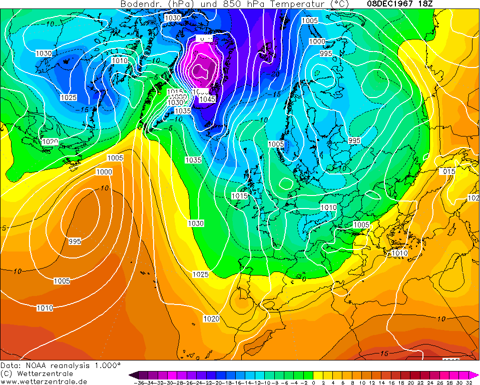
I am again left with the impression that northerlies are relatively impotent, and notably less severe than they were in past decades, particularly the latter decades of the twentieth century.  I would be very interested to see what others think about this apparant reality.  In the spirit of exploring this idea, I attach an image (and a link) of a typical northerly synoptic set up from early December 1967 - 10 uppers in fact made it into Normandy, with -15c approaching the north of Scotland.  There was a notable snowstorm in Brighton:


http://www.wetterzentrale.de/reanalysis.php?uur=1800&var=2&nmaps=24&map=1&model=noaa&jaar=1967&maand=12&dag=08


early dec 1967


A broadly  similar synoptic picture to the early December 2017 scenario as depicted by the ECM this morning, almost 50 years later to the day:


http://old.wetterzentrale.de/topkarten/fsecmeur.html


ecm dec 2017


Yes, I realise there are differences and no two synoptic situations are identical.  However, a not dissimilar outbreak of Arctic Air 50 years later and the -10 isotherm runs out at The Faroe Islands and the -5 isotherm gets tethered by the time it reaches the south coast.


It seems to me that the loss of ice in The Arctic and the melting of the Greenland Ice sheet are combining with positive SST anomalies and a warmer atmosphere (paricularly in high latitides) to make northerlies a much reduced force in the British Winter.  This is a pity, as they have been my favourite air mass (true Arctic Air) with its clairity and convection, and in the past, attendant chance of southern snow.


I realise that the two charts are different as the Greenalnd high is stronger in 1967 and the 2017 forecast is more of a mid Atlantic omega with a northern extension, but the differences in the reservoir of deep cold for us to tap into, are much reduced, sadly, in my opinion.


I am happy to have someone more knowledgeable than myself deconstruct my supposition, as it would be great see a similar Arctic outbreak as December 1967 brought us. Similarly, I would apprecaite some considered input from anyone knowledgeable who agrees.  Im not wanting to turn the MO thread into the climate forum! But I am irritated at the current northerlies not being what they used to be.  "The north wind doth blow and we shall have snow" could be replaced with "... and we shall have wintriness at high levels in the north".


Doesn't the bolded paragraph answer your question though? The two charts are indeed different. The purples in 1967 were concentrated entirely in northern Greenland, in the perfect spot for those synoptics to send them flowing on a narrow lane south through the British Isles; the 2017 chart, by contrast, shows the purple cold still present - it's just that it's all over the other side of the Pole from us.


In other words, the "reservoir of deep cold" to which you refer looks no different to me in terms of volume on those two charts, but entirely different in terms of position.


If you can find a historical chart which brings the -10 isotherm into Normandy on the basis of a northerly where there's a concentration of purples over the other side of the Pole similar to the 2017 chart, then in that case I'd agree, something must have changed. I just don't think the current set-up is a fair comparison.


2 miles west of Taunton, 32 m asl, where "milder air moving in from the west" becomes SNOWMAGEDDON.
Well, two or three times a decade it does, anyway.
Joe Bloggs
26 November 2017 10:22:04

The MetO raw data from their app is showing a low of -5C for here on Wednesday night. Pretty impressive.


I see 06z GFS is in line with all the other data and is toying with the idea of another northerly push 


http://www.wetterzentrale.de/maps/GFSOPEU06_186_1.png


A very consistent theme at present. 


Manchester City Centre, 31m ASL

Polar Low
26 November 2017 10:24:28

Originally Posted by: The Beast from the East 


Pert 6 shows what happens when the reload fails and we quickly return to our default setting and the Merkel slug


You were like this last year so down in the dumps Beast


please take 2 tablets three times a day until further notice


Agree about the Arctic warming. If the trend intensifies, any great charts will be pointless unless you live on a northern hill. Weather watchers will rapidly lose interest in chasing snow. I'm personally not certain I will see proper settling and lasting snow again in my lifetime, in London at sea level. 


Maunder Minimum
26 November 2017 10:27:42

Originally Posted by: Joe Bloggs 


The MetO raw data from their app is showing a low of -5C for here on Wednesday night. Pretty impressive.


I see 06z GFS is in line with all the other data and is toying with the idea of another northerly push 


http://www.wetterzentrale.de/maps/GFSOPEU06_186_1.png


A very consistent theme at present. 


Thar she blows:


New world order coming.
Rob K
26 November 2017 10:53:24

The overnight GFS ensemble (at least for London) shows a marked move away from continued cold with far more options reverting to a more westerly influence. Hopefully the ECM 00Z is closer to the mark showing a renewed retrogression to Greenland which the GFS was playing with but now seems to have given up on. (6Z GFS has a half-hearted attempt that quickly flattens out.)


Yateley, NE Hampshire, 73m asl
"But who wants to be foretold the weather? It is bad enough when it comes, without our having the misery of knowing about it beforehand." — Jerome K. Jerome
Maunder Minimum
26 November 2017 10:57:25

Originally Posted by: Rob K 


The overnight GFS ensemble (at least for London) shows a marked move away from continued cold with far more options reverting to a more westerly influence. Hopefully the ECM 00Z is closer to the mark showing a renewed retrogression to Greenland which the GFS was playing with but now seems to have given up on. (6Z GFS has a half-hearted attempt that quickly flattens out.)


I noticed that (the half hearted attempt followed by a flattening). We are all experienced enough to know that the computer models are only an approximation of what might happen and that stellar charts can quickly be replaced by the usual fare. All eyes will be on ECM later.


New world order coming.
The Beast from the East
26 November 2017 11:07:15

Originally Posted by: Rob K 


The overnight GFS ensemble (at least for London) shows a marked move away from continued cold with far more options reverting to a more westerly influence. Hopefully the ECM 00Z is closer to the mark showing a renewed retrogression to Greenland which the GFS was playing with but now seems to have given up on. (6Z GFS has a half-hearted attempt that quickly flattens out.)


Indeed. Yet again, we see northern blocking failing to take hold. GFS op shows this well. What we have now is the familiar pattern of modern times of mid latitude blocking that occasionally ridges north and gives us a taste of cold air, then topples to allow milder atlantic air in


Its disappointing but an air of inevitability about it. 


"We have some alternative facts for you"
Kelly-Ann Conway - special adviser to the President
Joe Bloggs
26 November 2017 11:09:55

Originally Posted by: The Beast from the East 


Indeed. Yet again, we see northern blocking failing to take hold. GFS op shows this well. What we have now is the familiar pattern of modern times of mid latitude blocking that occasionally ridges north and gives us a taste of cold air, then topples to allow milder atlantic air in


Its disappointing but an air of inevitability about it. 


Hi Beast. Do you fancy providing some analysis about what you think is likely to happen in the medium/long range? Would be interested to know your objective thoughts. Some charts to back these up would be helpful.


I agree the GEFS have certainly backed away somewhat from a long term cold setup this morning. 


Manchester City Centre, 31m ASL

David M Porter
26 November 2017 11:17:40

Originally Posted by: The Beast from the East 


Indeed. Yet again, we see northern blocking failing to take hold. GFS op shows this well. What we have now is the familiar pattern of modern times of mid latitude blocking that occasionally ridges north and gives us a taste of cold air, then topples to allow milder atlantic air in


Its disappointing but an air of inevitability about it. 


Nothing is inevitable unless or until it becomes a near-certainty to happen. As I see it at the moment, it is by no means inevitable that the high will topple. I seem to recall the GFS in a number of runs a few says back showed something like this happening this week but then dropped the idea.


Lenzie, Glasgow

"Let us not take ourselves too seriously. None of us has a monopoly on wisdom, and we must always be ready to listen and respect other points of view."- Queen Elizabeth II 1926-2022
marco 79
26 November 2017 11:27:40
06z looses the low pressure over the Azores thus allowing the flattening...I see the crucial part of the blocking is to ascertain the lows position..Current output has it moving East South East.. then fizzling out...allowing the block pattern to slide SE
Home : Mid Leicestershire ...135m ASL
The Beast from the East
26 November 2017 11:32:12

Originally Posted by: Joe Bloggs 


Hi Beast. Do you fancy providing some analysis about what you think is likely to happen in the medium/long range? Would be interested to know your objective thoughts. Some charts to back these up would be helpful.


I agree the GEFS have certainly backed away somewhat from a long term cold setup this morning. 


I only look at what the models show and factor in their inevitable bias to overdo northern heights and underestimate the jet


However, the latest set of GEFS look better, like this one


"We have some alternative facts for you"
Kelly-Ann Conway - special adviser to the President
Joe Bloggs
26 November 2017 11:32:59

06z GEFS


control http://www.wetterzentrale.de/maps/GFSC00EU06_240_1.png


P2 http://www.wetterzentrale.de/maps/GFSP02EU06_240_1.png


P5 http://www.wetterzentrale.de/maps/GFSP05EU06_240_1.png


P6 http://www.wetterzentrale.de/maps/GFSP06EU06_240_1.png


P9 http://www.wetterzentrale.de/maps/GFSP09EU06_240_1.png


Those are some of best for cold. The remainder show HP over the UK, the majority show a cold picture, and I think only one shows a mild SW’ly (at t+240).


We are still looking at a predominantly blocked and cold picture. 


Manchester City Centre, 31m ASL

pdiddy
26 November 2017 11:38:04

Originally Posted by: The Beast from the East 


Indeed. Yet again, we see northern blocking failing to take hold. GFS op shows this well. What we have now is the familiar pattern of modern times of mid latitude blocking that occasionally ridges north and gives us a taste of cold air, then topples to allow milder atlantic air in


Its disappointing but an air of inevitability about it. 


You may be right... but equally we know from experience how badly the models cope with retrogression of the highs.  I'm happy enough that the next few days (after the mild blip) will bring colder conditions, but I'd like to see some runs hitting that -10 for the 850hPa:


http://old.wetterzentrale.de/pics/MT8_Aberdeen_ens.png


I think we may see a more NW flow over the next few weeks as you suggest, but hope for something more noteworthy as the block ends up being harder to shift than models currently expect.


David M Porter
26 November 2017 11:41:01

Originally Posted by: The Beast from the East 


I only look at what the models show and factor in their inevitable bias to overdo northern heights and underestimate the jet


Sometimes they can do the reverse as well, i.e overdo the strength of the jet and underestimate the strength of a HP block (and I don't mean necessarily one situated at northern latitudes). I've seen this happen at all times of the year in the past, not just during the winter.


Lenzie, Glasgow

"Let us not take ourselves too seriously. None of us has a monopoly on wisdom, and we must always be ready to listen and respect other points of view."- Queen Elizabeth II 1926-2022
Users browsing this topic

Ads