Quantum
  • Quantum
  • Advanced Member Topic Starter
12 September 2017 09:57:40

I decided to look in more detail into the abundance of tropical activity in Europe. These are conventional tropical cyclones as officially declared by NOAA and do not include Medicanes. A few points to clear up: Hurricane force winds are rare but do occur in the UK. The last time sustained hurricane force winds occurred in the UK was probably 3rd January 2012 in the central belt with winds widely sustained in the low 70s. The 'Michael fish Hurricane' is a more infamous example. However these storms were not hurricanes despite being hurricane strength. A hurricane is a barotropic system, whereas these storms were baroclinic in nature (although often strong baroclinic systems started out life in the tropics as hurricanes).  In order to get a true hurricane to hit Europe two criteria would have to be satisfied:   


1) Hurricane force winds
2) Storm is barotropic           


Satisfying both criteria at the same time is extremely difficult in Europe though I have reason to believe it is actually possible just vanishingly rare (probably a 1 in 1000 year event for the UK). The real issue is getting a tropical cyclone that has already formed to remain tropical long enough to make landfall with the UK. Contrary to popular belief the low sea surface temperatures are not the main issue, but the ultra high wind shear environment that literally rips storms apart. Essentially the problem comes down to the wind shear either being low enough or the storm moving fast enough that the extratropical transition doesn't have time to occur. Both of these two solutions have been attempted. 


Above are some schematic tracks with marks depicting the location at which the extratropical transition occurred for storms particularly far north or east. Tropical cyclones originating further south tend to get further north but also decay further west while storms originating further north get much further east. The former category includes very strong cyclones (often storms that obtained major cat3+ status during their lifetime) whilst the later contains much weaker storms (usually TD-C1 strength). In the former case its simply a matter of speed, run as fast as possible so you can die further NE, whilst the later category doesn't need to be strong or fast because the wind shear is marginal rather than devastating.      


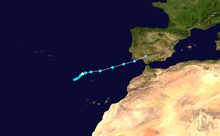
As you can see from the map storms have nearly made it into Europe with a cluster of dying tropical cyclones just to the south west of the UK and to the west of Spain. Here are a few case Studies.

Hurricane Debbie (1961)


Disputed landfall as a category 1 hurricane in Ireland. However even before the disputed transition the hurricane's cloud field still affected Ireland. Therefore even if it didn't landfall it is the only undisputed case, ever, of a true hurricane affecting the British Isles. 


Hurricane Faith (1966)


Underwent extratropical transition as a category 1 hurricane just to the east of the Faero Isles. This is the furthest North a hurricane has ever managed to get before transitioning 


Hurricane Vince (2005)


The only undisputed landfall of a tropical cyclone in Europe. Vince briefly made Cat 1 status although it landfilled as a tropical depression in Spain. 


Hurricane Chloe (1967)


The closest a barotropic system has ever come to France. Disputed records indicate it may have been within 30 miles of the French coast before the, at that point, tropical storm underwent transition. 


Tropical storm Grace (2009)


Probably the closest a barotropic system has ever come to landfalling in great Briton. Its latitude was the same as cornwall when it underwent transition and its remnants (which still had hybrid characteristics) landfilled in wales just a few hours later. 


Hurricane Fran (1973) 


The category 1 counterpart to Grace. Its transition occurred while it was slightly further south but did so while a catogary 1. 


Meeting the first criteria doesn't seem difficult for the UK. Since the UK is further north the systems that come close are more likely to be catogary 1 strength when they transition. For the likes of Spain or France this would be more of an issue with weaker storms having a better chance of staying alive long enough before they transition. Anyway the likes of Faith and Debbie, in particular, prove it is possible for a Storm to hit the UK and SW Scotland is probably the best bet for a category 1 just before transition. It will happen eventually but not necessarily in our lifetimes. Europe is right on the periphery of where a tropical cyclone can survive, and only the most resilient manage to get that far before transitioning. 


EDIT: Forgot to mention, if tropical cyclones in unusual places is something that interests you, check out my YouTube video on my top 5 favourite tropical cyclones of all time (some are mentioned above). These are cyclones that ended up in very unusual places!


https://www.youtube.com/watch?v=aZLdB_2Ulzw


Twitter: @QuantumOverlord (general), @MedicaneWatch (medicane/TC stuff)
2023/2024 Snow days (approx 850hpa temp):
29/11 (-6), 30/11 (-6), 02/12 (-5), 03/12 (-5), 04/12 (-3), 16/01 (-3), 18/01 (-8), 08/02 (-5)

Total: 8 days with snow/sleet falling.

2022/2023 Snow days (approx 850hpa temp):

18/12 (-1), 06/03 (-6), 08/03 (-8), 09/03 (-6), 10/03 (-8), 11/03 (-5), 14/03 (-6)

Total: 7 days with snow/sleet falling.

2021/2022 Snow days (approx 850hpa temp):

26/11 (-5), 27/11 (-7), 28/11 (-6), 02/12 (-6), 06/01 (-5), 07/01 (-6), 06/02 (-5), 19/02 (-5), 24/02 (-7), 30/03 (-7), 31/03 (-8), 01/04 (-8)
Total: 12 days with snow/sleet falling.
Arcus
12 September 2017 10:30:50
Very interesting read Q - thanks for putting this together. I would only point out that Faith underwent transition near the Faroe Islands rather than the Falkland Islands. :)

Ben,
Nr. Easingwold, North Yorkshire
30m asl
yorkshirelad89
12 September 2017 10:42:17

I think some literature has suggested that the big storm of 1703 may have been an ex hurricane turned into a post tropical cyclone. I can imagine one of these getting caught up in a strong cold/warm air boundary would be pretty intense.


I can imagine a hurricane influencing the UK being a possibility, albeit a very tiny one.


Hull
Gusty
12 September 2017 11:11:43

An interesting thread Q.


What characteristics determine the difference between barotropic and baroclinic and what is the transition ?


Thanks 


Steve - Folkestone, Kent
Current conditions from my Davis Vantage Vue
https://www.wunderground.com/dashboard/pws/IFOLKE11 
Join Kent Weather on Facebook.
https://www.facebook.com/stevewall69/ 


ARTzeman
12 September 2017 13:19:38

 Good Post. Good Information. 


Some people walk in the rain.
Others just get wet.
I Just Blow my horn or trumpet
Solar Cycles
12 September 2017 14:09:36
What a great thread, I think I'm better off in here regarding hurricanes than the climate thread. Thanks for all the hard work you've put up into this Q I'll bookmark your YouTube link for future reference.
Quantum
  • Quantum
  • Advanced Member Topic Starter
12 September 2017 14:23:52

Originally Posted by: Gusty 


An interesting thread Q.


What characteristics determine the difference between barotropic and baroclinic and what is the transition ?


Thanks 


In a technical sense, barotropic means alignment of density with pressure levels although because warmer air is less dense this also means an alignment of pressure and temperature levels, i.e no significant horizontal temperature gradients but locally warm within a low pressure centre. This brings us to the two main characteristics of a barotropic system: Warm cored (which also means the storm is stronger near the surface than the upper atmosphere) and symmetrical (i.e does not have fronts).


When a barotropic system moves into the high latitudes it gains baroclinic properties, the transition is associated with the warm core opening out into a warm sector and cold air filling the northern portion of the cyclone. During the extratropical transition fronts develop and the cyclone looses its symmetry.


Twitter: @QuantumOverlord (general), @MedicaneWatch (medicane/TC stuff)
2023/2024 Snow days (approx 850hpa temp):
29/11 (-6), 30/11 (-6), 02/12 (-5), 03/12 (-5), 04/12 (-3), 16/01 (-3), 18/01 (-8), 08/02 (-5)

Total: 8 days with snow/sleet falling.

2022/2023 Snow days (approx 850hpa temp):

18/12 (-1), 06/03 (-6), 08/03 (-8), 09/03 (-6), 10/03 (-8), 11/03 (-5), 14/03 (-6)

Total: 7 days with snow/sleet falling.

2021/2022 Snow days (approx 850hpa temp):

26/11 (-5), 27/11 (-7), 28/11 (-6), 02/12 (-6), 06/01 (-5), 07/01 (-6), 06/02 (-5), 19/02 (-5), 24/02 (-7), 30/03 (-7), 31/03 (-8), 01/04 (-8)
Total: 12 days with snow/sleet falling.
Chunky Pea
12 September 2017 14:26:06

Hurricane Debbie did not 'make landfall' as such here in Ireland, but it destroyed the region I live in almost completely. Stories I have heard from my parents (who where just kids at the time) and from the older generation who experienced this storm are incredible.


From the info I have gathered over the years by listening to countless accounts of this storm in my region:


  1. It hit very suddenly.

  2. Scarily, many reported that a sort of 'screaming' sound was heard shortly before the storm hit.

  3. A huge forest to the north of the town I am living in was felled completely in a very short space of time, as was many other forests around the country.

  4. A strange yellow, hovering 'hue' was noted by many before the storm's arrival.

  5. Possible tornadic activity embedded. 


Current Conditions
https://t.ly/MEYqg 


"You don't have to know anything to have an opinion"
--Roger P, 12/Oct/2022
Solar Cycles
12 September 2017 14:30:16

Originally Posted by: Chunky Pea 


Hurricane Debbie did not 'make landfall' as such here in Ireland, but it destroyed the region I live in almost completely. Stories I have heard from my parents (who where just kids at the time) and from the older generation who experienced this storm are incredible.


From the info I have gathered over the years by listening to countless accounts of this storm in my region:


  1. It hit very suddenly.

  2. Scarily, many reported that a sort of 'screaming' sound was heard shortly before the storm hit.

  3. A huge forest to the north of the town I am living in was felled completely in a very short space of time, as was many other forests around the country.

  4. A strange yellow, hovering 'hue' was noted by many before the storm's arrival.

  5. Possible tornadic activity embedded. 


👍🏻

ozone_aurora
12 September 2017 15:18:58

There was also the ex-hurricane Bertha of 9-10 August 2014, which became a rather disorganised feature to the SW of UK, then brought us particularly thundery conditions leading to quite deep extratropical low pressure with strong winds.
The legacy of this was a marked transformation from warm sultry conditions of early August to notably cool showery westerlies and northwesterlies for the rest of the month.

Quantum
  • Quantum
  • Advanced Member Topic Starter
12 September 2017 16:18:29

Originally Posted by: ozone_aurora 


There was also the ex-hurricane Bertha of 9-10 August 2014, which became a rather disorganised feature to the SW of UK, then brought us particularly thundery conditions leading to quite deep extratropical low pressure with strong winds.
The legacy of this was a marked transformation from warm sultry conditions of early August to notably cool showery westerlies and northwesterlies for the rest of the month.


Ex-Hurricanes are actually fairly common in the UK, probably happening somewhere between once a year and once every two years. The examples I have given are all the more remarkable because they were so close to being actual hurricanes/tropical storms when that close to the UK. 


Twitter: @QuantumOverlord (general), @MedicaneWatch (medicane/TC stuff)
2023/2024 Snow days (approx 850hpa temp):
29/11 (-6), 30/11 (-6), 02/12 (-5), 03/12 (-5), 04/12 (-3), 16/01 (-3), 18/01 (-8), 08/02 (-5)

Total: 8 days with snow/sleet falling.

2022/2023 Snow days (approx 850hpa temp):

18/12 (-1), 06/03 (-6), 08/03 (-8), 09/03 (-6), 10/03 (-8), 11/03 (-5), 14/03 (-6)

Total: 7 days with snow/sleet falling.

2021/2022 Snow days (approx 850hpa temp):

26/11 (-5), 27/11 (-7), 28/11 (-6), 02/12 (-6), 06/01 (-5), 07/01 (-6), 06/02 (-5), 19/02 (-5), 24/02 (-7), 30/03 (-7), 31/03 (-8), 01/04 (-8)
Total: 12 days with snow/sleet falling.
Rob K
12 September 2017 18:48:01
What about Hurricane Bawbag? ;)

Yateley, NE Hampshire, 73m asl
"But who wants to be foretold the weather? It is bad enough when it comes, without our having the misery of knowing about it beforehand." — Jerome K. Jerome
Gusty
12 September 2017 19:44:44

Originally Posted by: Quantum 


In a technical sense, barotropic means alignment of density with pressure levels although because warmer air is less dense this also means an alignment of pressure and temperature levels, i.e no significant horizontal temperature gradients but locally warm within a low pressure centre. This brings us to the two main characteristics of a barotropic system: Warm cored (which also means the storm is stronger near the surface than the upper atmosphere) and symmetrical (i.e does not have fronts).


When a barotropic system moves into the high latitudes it gains baroclinic properties, the transition is associated with the warm core opening out into a warm sector and cold air filling the northern portion of the cyclone. During the extratropical transition fronts develop and the cyclone looses its symmetry.


Thanks Q. I suspected it was something to do with the introduction of air masses /fronts. Very helpful 


Steve - Folkestone, Kent
Current conditions from my Davis Vantage Vue
https://www.wunderground.com/dashboard/pws/IFOLKE11 
Join Kent Weather on Facebook.
https://www.facebook.com/stevewall69/ 


Users browsing this topic

    Ads