TimS
  • TimS
  • Advanced Member Topic Starter
20 June 2022 10:49:37

There are some quite consistent early warning signs for what would be a historic, probably record breaking and certainly dangerous heat dome forming over the central Med from Tunisia through Italy up to the Balkans, starting this weekend, peaking the following weekend and lasting until at least early July.


Data based on GFS output but a similar pattern is showing in ECM, albeit with a few nuances. It's been showing up for a number of runs in a row which makes me fairly confident there is a real risk here.


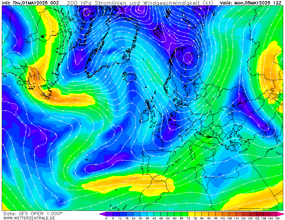
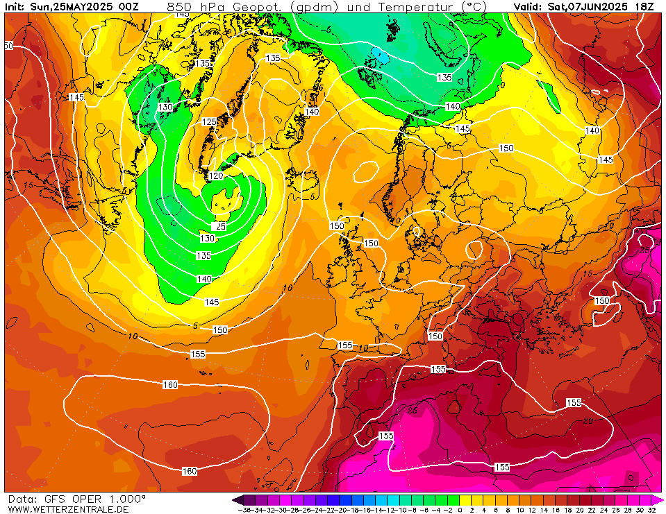
We're looking at a stuck jet stream pattern with a trough over Ireland and strong and persistent ridging in the central Med. Here's how it develops synoptically:


1. The subtropical jet pumps up, driven by troughing in the North Atlantic, and starts to arc over Italy:


2. A (rare) summer version of a Bartlett / Euro high develops over the Alps, extending unusually high pressure over the central Med which would usually be hovering around 1010-1015hPa after the solstice


3. This drags up VERY hot Saharan air from Algeria and Tunisia, and it then stays there for days and days, slowly spreading North-Eastwards towards the Balkans. 


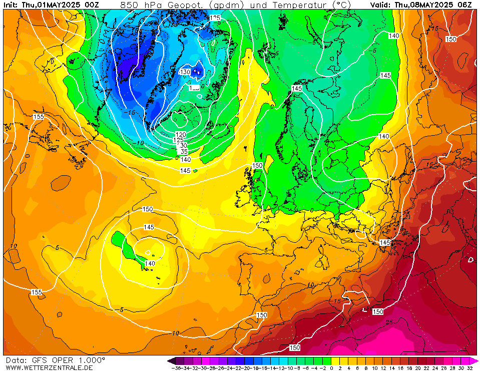
The intense heat starts early next week in Tunisia, Sicily, Sardinia and the Mezzogiorno.


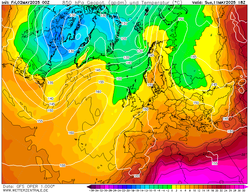
But it really gets going further North later in the week. The daytime values are frightening, e.g. 45C in the Po Valley, Inland Sardinia, Serbia (peaking at 46C the next day)


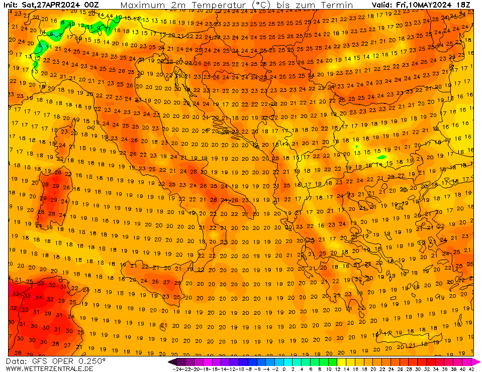
Parts of Southern Italy reach >40C daily for 14 days (and are still going at the end of the run).


Night minima widely from 27-30C in coastal areas too, which is murderous:


This is one to watch. To avoid this we need the jet to flatten and ridge a little over the UK and to our North East, which will bring us better weather and suppress the heat dome in the Med too.  


Brockley, South East London 30m asl
Ally Pally Snowman
20 June 2022 11:17:51

That looks brutal. 


Sooner or later it will be our turn maybe this year?


Bishop's Stortford 85m ASL.
Jiries
20 June 2022 18:57:31

Originally Posted by: Ally Pally Snowman 


That looks brutal. 


Sooner or later it will be our turn maybe this year?


Want that to see it happening here, it need to experience extreme heat for days and days not 1 day nonsense, no use to that and waste of time.  With the strong heat UK cannot avoid forever.  With last Friday Nuneaton reached 31C and London 32C so it make me wonder that being in right in middle of Midlands how well we get the heat if this come up? London 41-42C and Nuneaton 39-40C? Leeds and York 37-38C?  York was 29C last Friday so that the highest temps and far north than here.

TimS
  • TimS
  • Advanced Member Topic Starter
20 June 2022 19:31:58

Originally Posted by: Jiries 


Want that to see it happening here, it need to experience extreme heat for days and days not 1 day nonsense, no use to that and waste of time.  With the strong heat UK cannot avoid forever.  With last Friday Nuneaton reached 31C and London 32C so it make me wonder that being in right in middle of Midlands how well we get the heat if this come up? London 41-42C and Nuneaton 39-40C? Leeds and York 37-38C?  York was 29C last Friday so that the highest temps and far north than here.


It will happen in your lifetime, I’m pretty sure of that.


However, I really don’t want to see this one happening in the central Med. Just too brutal and dangerous. The good news is that anything which improves our weather will weaken the heatwave: either the trough remains further West and pressure rises over NE Europe (as hinted on tonight’s GFS) which spreads the heat out further but thinner, or the trough blasts through quickly then pressure builds right over us (as implied in this evening’s ECM) which punctures the heat dome completely.


Brockley, South East London 30m asl
Jiries
20 June 2022 20:53:29

Originally Posted by: TimS 


It will happen in your lifetime, I’m pretty sure of that.


However, I really don’t want to see this one happening in the central Med. Just too brutal and dangerous. The good news is that anything which improves our weather will weaken the heatwave: either the trough remains further West and pressure rises over NE Europe (as hinted on tonight’s GFS) which spreads the heat out further but thinner, or the trough blasts through quickly then pressure builds right over us (as implied in this evening’s ECM) which punctures the heat dome completely.


Cyprus had brutal hot 2 summers but this year a lot cooler and now on average and no 40 yet, when in 2020 was 59 times hitting 40 and over. Nearly July and no signs of that.  I agreed about mid Med too hot because it bottled up at the moment but should not be long time and spread our to other places and here some often decent warm to hot days for rest of summer. 

Saint Snow
20 June 2022 21:21:39

Oh, jesus. We're off to Malta a week Friday (1st July) 


Thankfully the hotel room has air con and there's a pool. 


I think I'll live in the pool. 


Martin
Home: St Helens (26m asl) Work: Manchester (75m asl)
A TWO addict since 14/12/01
"How can wealth persuade poverty to use its political freedom to keep wealth in power? Here lies the whole art of Conservative politics."
Aneurin Bevan
Zubzero
20 June 2022 21:31:34

Originally Posted by: Saint Snow 


Oh, jesus. We're off to Malta a week Friday (1st July) 


Thankfully the hotel room has air con and there's a pool. 


I think I'll live in the pool. 


Don't  forget safety  first 


https://m.media-amazon.com/images/I/618su3fEjpL._AC_SX679_.jpg


TimS
  • TimS
  • Advanced Member Topic Starter
21 June 2022 17:35:15
Quantum
22 June 2022 10:12:50

High of 43C tommorow in the south.


This is going to be exceptional. We are looking at a week where everyday sees 40C+


By the weekend 45C+ looks likely in the south and scicily.


Twitter: @QuantumOverlord (general), @MedicaneWatch (medicane/TC stuff)
2023/2024 Snow days (approx 850hpa temp):
29/11 (-6), 30/11 (-6), 02/12 (-5), 03/12 (-5), 04/12 (-3), 16/01 (-3), 18/01 (-8), 08/02 (-5)

Total: 8 days with snow/sleet falling.

2022/2023 Snow days (approx 850hpa temp):

18/12 (-1), 06/03 (-6), 08/03 (-8), 09/03 (-6), 10/03 (-8), 11/03 (-5), 14/03 (-6)

Total: 7 days with snow/sleet falling.

2021/2022 Snow days (approx 850hpa temp):

26/11 (-5), 27/11 (-7), 28/11 (-6), 02/12 (-6), 06/01 (-5), 07/01 (-6), 06/02 (-5), 19/02 (-5), 24/02 (-7), 30/03 (-7), 31/03 (-8), 01/04 (-8)
Total: 12 days with snow/sleet falling.
Quantum
22 June 2022 10:17:09

uploaded image


These are the places to watch. The wind will be quite variable but usually coming from that southern half. And since it could be fairly moist at times coming off the med, we could see some foehn effects. Foehn + very hot airmass means the circled areas have the best chance of breaking records.


Twitter: @QuantumOverlord (general), @MedicaneWatch (medicane/TC stuff)
2023/2024 Snow days (approx 850hpa temp):
29/11 (-6), 30/11 (-6), 02/12 (-5), 03/12 (-5), 04/12 (-3), 16/01 (-3), 18/01 (-8), 08/02 (-5)

Total: 8 days with snow/sleet falling.

2022/2023 Snow days (approx 850hpa temp):

18/12 (-1), 06/03 (-6), 08/03 (-8), 09/03 (-6), 10/03 (-8), 11/03 (-5), 14/03 (-6)

Total: 7 days with snow/sleet falling.

2021/2022 Snow days (approx 850hpa temp):

26/11 (-5), 27/11 (-7), 28/11 (-6), 02/12 (-6), 06/01 (-5), 07/01 (-6), 06/02 (-5), 19/02 (-5), 24/02 (-7), 30/03 (-7), 31/03 (-8), 01/04 (-8)
Total: 12 days with snow/sleet falling.
Hungry Tiger
22 June 2022 10:33:33

Originally Posted by: Quantum 


High of 43C tommorow in the south.


This is going to be exceptional. We are looking at a week where everyday sees 40C+


By the weekend 45C+ looks likely in the south and scicily.


Gavin S. FRmetS.
TWO Moderator.
Contact the TWO team - [email protected]
South Cambridgeshire. 93 metres or 302.25 feet ASL.


TimS
  • TimS
  • Advanced Member Topic Starter
22 June 2022 10:52:34

The latest runs show the heatwave more constrained in space (further South and not such extreme heat up into Serbia and Croatia), and not quite as intense as before. It's been saved a little by modelled pressure rises over NE Europe which shift the centre of the descending air a little. But it'll still be blisteringly hot for an extended period.


Highest values on Italian mainland and Islands in this morning's 06z GFS up to next Sat:


40, 41, 41, 40, 41, 43, 44, 42, 41, 41, 41


Bear in mind when I started this thread we were seeing modelled maxes of 46-48C in NE Italy and Serbia. So if this heatwave makes the news it's worth thinking what it might have been if the pattern had been a little different. 


Brockley, South East London 30m asl
TimS
  • TimS
  • Advanced Member Topic Starter
22 June 2022 10:56:32
Note things are already pretty bad in Northern Italy, worse than 2003:

https://www.thetimes.co.uk/article/4de42710-eff9-11ec-b0c8-27c99cdfb733?shareToken=0543f2fe69467b8de88eba7785835070 

Complete with a plague of locusts in Sardinia.
Brockley, South East London 30m asl
Hungry Tiger
22 June 2022 13:24:44

Keep us informed Tim - Seriously interesting this is.


Gavin S. FRmetS.
TWO Moderator.
Contact the TWO team - [email protected]
South Cambridgeshire. 93 metres or 302.25 feet ASL.


Hungry Tiger
24 June 2022 13:28:10

Keep tabs on this Tim. What are things like atm.


Gavin S. FRmetS.
TWO Moderator.
Contact the TWO team - [email protected]
South Cambridgeshire. 93 metres or 302.25 feet ASL.


TimS
  • TimS
  • Advanced Member Topic Starter
24 June 2022 14:44:35

The heatwave now looking a little more intense again, but with an end point next weekend as high pressure builds over Western Europe. The most intense heat generally in the South but quite widespread across mainland and islands, and creeping into the Baltics.


Max temps in Italy per today's GFS 06z (similar to last few runs), from today:


41 (Sicily), 40 (Sicily), 40 (Tuscany & Sicily), 43 (Molise), 44 (Basilicata), 43 (Molise), 42 (Sicily), 44 (Molise - also the peak at 42C in Serbia), 43 (Sicily).


There have been occasional 45s showing up in some runs.


Brockley, South East London 30m asl
westv
24 June 2022 15:03:00
This is one of the reasons I would never book a holiday in the Med region during mid June to end of August.
At least it will be mild!
Lionel Hutz
24 June 2022 15:21:54

Originally Posted by: TimS 


The heatwave now looking a little more intense again, but with an end point next weekend as high pressure builds over Western Europe. The most intense heat generally in the South but quite widespread across mainland and islands, and creeping into the Baltics.


Max temps in Italy per today's GFS 06z (similar to last few runs), from today:


41 (Sicily), 40 (Sicily), 40 (Tuscany & Sicily), 43 (Molise), 44 (Basilicata), 43 (Molise), 42 (Sicily), 44 (Molise - also the peak at 42C in Serbia), 43 (Sicily).


There have been occasional 45s showing up in some runs.


Thanks for keeping tabs on this, Tim(to echo Gavin). We're due to be in Grado(in the North East, near Trieste)for a week beginning tomorrow(Ryanair strike allowing) so I've been watching this carefully. Luckily, it looks like we'll avoid the worst of the heat. Plus, we'll be right by the sea. 


Lionel Hutz
Nr.Waterford , S E Ireland
68m ASL


Jiries
24 June 2022 15:50:17

Originally Posted by: westv 

This is one of the reasons I would never book a holiday in the Med region during mid June to end of August.


You should, I would get away from the cloud infection country.  Really boring here today no sun and no action while there action heat over there.

Lionel Hutz
28 June 2022 19:06:40

According to one of the Italian papers today, five Italian cities managed record June temperatures. Florence was the highest at 40.2, followed by Viterbo at 39.8 and Rome at 39. 


Lionel Hutz
Nr.Waterford , S E Ireland
68m ASL


Users browsing this topic

Ads