nsrobins
20 February 2017 11:41:56

Originally Posted by: warrenb 

am little more focused on the Low on Thursday which is due to go straight through the middle of the country with gale force winds, heavy rain and dare I say it snow.
I don't care about cold charts at 300 hours.


I don't really 'care' about them either, but it's model output so worthy of mention. The 06GFS again delivers an easterly late on with the heights building mid-Atlantic as early as next Monday. A last throw of the dice?


Neil
Fareham, Hampshire 28m ASL (near estuary)
Stormchaser, Member TORRO
Cumbrian Snowman
20 February 2017 11:55:19

Originally Posted by: warrenb 

am little more focused on the Low on Thursday which is due to go straight through the middle of the country with gale force winds, heavy rain and dare I say it snow.
I don't care about cold charts at 300 hours.


Definatley one to watch -  could be a bit of snow on the North Pennines


Showing as sleet for me an 2c most of Thursday


Gavin D
20 February 2017 12:05:53

06z ens


nsrobins
20 February 2017 12:51:06
Arctic 2m Ts set to continue to fall into early March, with many stations due to have colder air in place than at any time this 'winter'. Not a bad time for a decent NE flow which will overcome the increase in solar heating.
Not a forecast, just a bit of gratuitous 😎
Neil
Fareham, Hampshire 28m ASL (near estuary)
Stormchaser, Member TORRO
Foghorn
20 February 2017 13:11:53
Another frigid looking set of charts in the not too distant future - enough to provide interest if it is supported by later runs but I don't hold out much hope on the basis of recent GFS performance. However spring is coming and when you get spring in the winter the flipside is usually inevitable....
JACKO4EVER
20 February 2017 17:30:00
Frigid?
All looks rather tame to me, perhaps a few cooler days. Roll on Spring
Hippydave
20 February 2017 18:35:27

Be interesting to see what direction the ECM FI takes this evening - GFS still has a wide range of options, although the colder cluster is a little more populated than perhaps it has been:-
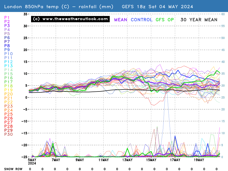


The Op run manages to bring some (falling) snow for quite a few fromT195 on with LP sinking South over us and drawing some cold air in with it. In the reliable remaining mild until a noticeable change in temps for  a day before an equally sharp recovery (down here). There's quite good agreement after that for it to turn cooler although whether it's cool, average or cold remains to be seen. Excessively mild is looking unlikely longer term at the moment but given there's a fair bit of HP in the ens it wouldn't take a massive shift for us to get some more mild, dryish weather again.


Home: Tunbridge Wells
Work: Tonbridge
tallyho_83
20 February 2017 18:54:27

Few colder ensembles in FI ,according to the 12z run: - Not going to post all but you get the idea:


Love the 1080mb - that would be good.


Home Location - Kellands Lane, Okehampton, Devon (200m ASL)
---------------------------------------
Sean Moon
Magical Moon
www.magical-moon.com


Gavin D
20 February 2017 18:54:41

The coldest 850's from ECM are at t96


If ever a chart summed up our winter for missing out on the coldest air


Users browsing this topic

Ads